Property Record
1001 S Milpitas Blvd, Milpitas, CA 95035

Property Detail
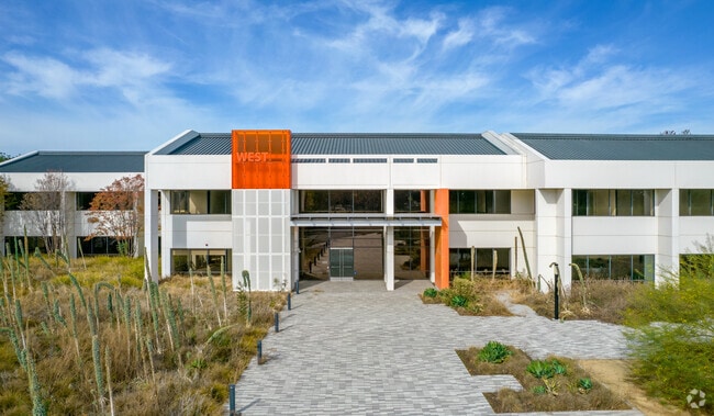
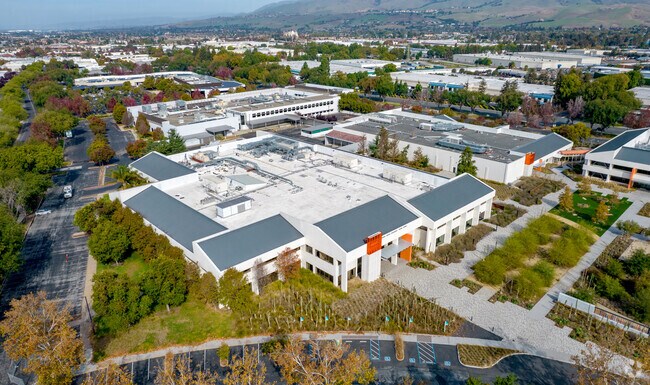
1001 S Milpitas Blvd
Scientificpharmaceuticalmedicalresearchfacility
Santa Clara
C
California
C and X Area of minimal flood hazard, usually depicted on FIRMs as above the 500-year flood level.
28.95 AC
2024
Milpitas
2025
South Bay/San Jose
504509
San Jose-Sunnyvale-Santa Clara, CA
143,242 SF
086-42-033
NEARBY LISTINGS FOR SALE OR LEASE
DEMOGRAPHICS near 1001 S Milpitas Blvd
1 mile
3 mile
5 mile
2025 Total Population
29,767
166,191
315,625
2030 Population
31,278
169,959
321,867
Pop Growth 2025-2030
+ 5.08%
+ 2.27%
+ 1.98%
Average Age
35
39
39
2025 Total Households
10,258
54,358
103,310
HH Growth 2025-2030
+ 5.28%
+ 2.40%
+ 2.08%
Median Household Inc
$198,769
$184,726
$165,531
Avg Household Size
2.90
3.00
2.90
2025 Avg HH Vehicles
2.00
2.00
2.00
Median Home Value
$1,092,311
$1,091,370
$1,079,999
Median Year Built
2010
1988
1985
Nearby Places
Map Layers
Map Styles
 Street
 Aerial
Layers
 Traffic
 Biking
Places
Listings with unknown addresses are not visible on the map
- Restaurants
- Banks
- Shops
- Fitness
- Groceries
PUBLIC TRANSPORTATION
TRANSIT/SUBWAY
Milpitas (Berryessa/North San Jose to Daly City - Bay Area Rapid Transit (BART), Berryessa/North San Jose to Richmond - Bay Area Rapid Transit (BART), Daly City to Berryessa/North San Jose - Bay Area Rapid Transit (BART), Richmond to Berryessa/North San Jose - Bay Area Rapid Transit (BART))
Drive
Walk
Distance
Milpitas (Berryessa/North San Jose to Daly City - Bay Area Rapid Transit (BART), Berryessa/North San Jose to Richmond - Bay Area Rapid Transit (BART), Daly City to Berryessa/North San Jose - Bay Area Rapid Transit (BART), Richmond to Berryessa/North San Jose - Bay Area Rapid Transit (BART))
4 min
19 min
1.0 mi
COMMUTER RAIL
Great America-Santa Clara (ACE Train - Capitol Corridor Joint Powers Authority, Capitol Corridor - Capitol Corridor Joint Powers Authority)
Drive
Walk
Distance
Great America-Santa Clara (ACE Train - Capitol Corridor Joint Powers Authority, Capitol Corridor - Capitol Corridor Joint Powers Authority)
12 min
6.9 mi
Santa Clara Caltrain Station Northbound (Limited - Caltrain (Caltrain), Local Weekday - Caltrain (Caltrain), Local Weekend - Caltrain (Caltrain))
Drive
Walk
Distance
Santa Clara Caltrain Station Northbound (Limited - Caltrain (Caltrain), Local Weekday - Caltrain (Caltrain), Local Weekend - Caltrain (Caltrain))
14 min
8.3 mi
AIRPORT
Norman Y Mineta San Jose International
Drive
Walk
Distance
Norman Y Mineta San Jose International
13 min
6.5 mi
Metro Oakland International
Drive
Walk
Distance
Metro Oakland International
41 min
30.8 mi
San Francisco International
Drive
Walk
Distance
San Francisco International
46 min
35.3 mi
Freight Ports
Port of Redwood City
Drive
Walk
Distance
Port of Redwood City
31 min
22.2 mi
SALE & LEASE HISTORY
LISTING DATE
SALE/LEASE

Sep 25, 2016
For Lease
Nov 20, 2018
For Lease
Nearby Properties
Address
Land Use
TOTAL SIZE
Lot Size
Zoning
Address
Land Use
TOTAL SIZE
Lot Size
Zoning
7.49 AC
M2
Address
Land Use
TOTAL SIZE
Lot Size
Zoning
194,597 SF
20.10 AC
I
Address
Land Use
TOTAL SIZE
Lot Size
Zoning
74,528 SF
9.26 AC
TEC
Address
Land Use
TOTAL SIZE
Lot Size
Zoning
1,282,514 SF
99.02 AC
C2-S
Address
Land Use
TOTAL SIZE
Lot Size
Zoning
423,160 SF
6.24 AC
A(PD)
Address
Land Use
TOTAL SIZE
Lot Size
Zoning
556,649 SF
8.09 AC
IP
Address
Land Use
TOTAL SIZE
Lot Size
Zoning
104,960 SF
10.19 AC
IP
Address
Land Use
TOTAL SIZE
Lot Size
Zoning
329,907 SF
3.94 AC
A(PD)
Address
Land Use
TOTAL SIZE
Lot Size
Zoning
503,840 SF
5.02 AC
MXD2
Address
Land Use
TOTAL SIZE
Lot Size
Zoning
350,507 SF
6.17 AC
APD
Address
Land Use
TOTAL SIZE
Lot Size
Zoning
328,189 SF
4.01 AC
R3
Address
Land Use
TOTAL SIZE
Lot Size
Zoning
3.72 AC
M2S
Address
Land Use
TOTAL SIZE
Lot Size
Zoning
5.21 AC
APD
Address
Land Use
TOTAL SIZE
Lot Size
Zoning
1,659,060 SF
6.42 AC
APD
Address
Land Use
TOTAL SIZE
Lot Size
Zoning
350,267 SF
3.44 AC
A(PD)
Address
Land Use
TOTAL SIZE
Lot Size
Zoning
310,021 SF
5.45 AC
APD
Address
Land Use
TOTAL SIZE
Lot Size
Zoning
7.61 AC
A(PD)
Address
Land Use
TOTAL SIZE
Lot Size
Zoning
505,150 SF
35.68 AC
CIC
Address
Land Use
TOTAL SIZE
Lot Size
Zoning
324,610 SF
3.27 AC
APD
Address
Land Use
TOTAL SIZE
Lot Size
Zoning
257,196 SF
3.50 AC
A(PD)
Address
Land Use
TOTAL SIZE
Lot Size
Zoning
642,249 SF
6.89 AC
A(PD)
Address
Land Use
TOTAL SIZE
Lot Size
Zoning
270,200 SF
17.48 AC
IP
Address
Land Use
TOTAL SIZE
Lot Size
Zoning
339,693 SF
5.39 AC
APD
Address
Land Use
TOTAL SIZE
Lot Size
Zoning
362,780 SF
7.58 AC
APD
Address
Land Use
TOTAL SIZE
Lot Size
Zoning
316,904 SF
5.08 AC
APD
Address
Land Use
TOTAL SIZE
Lot Size
Zoning
4.56 AC
M2
Address
Land Use
TOTAL SIZE
Lot Size
Zoning
366,149 SF
2.98 AC
R3
Address
Land Use
TOTAL SIZE
Lot Size
Zoning
538,119 SF
7.04 AC
A(PD)
Address
Land Use
TOTAL SIZE
Lot Size
Zoning
66,350 SF
19.51 AC
IP
The World's #1 Commercial Real Estate Marketplace
Connect with us
© 2026 CoStar Group
The information above has been obtained from sources believed reliable. While we do not doubt its accuracy we have not verified it and make no guarantee, warranty or representation about it. It is your responsibility to independently confirm its accuracy and completeness. Any projections, opinions, assumptions, or estimates used are for example only and do not represent the current or future performance of the property. The value of this transaction to you depends on tax and other factors which should be evaluated by your tax, financial, and legal advisors. You and your advisors should conduct a careful, independent investigation of the property to determine to your satisfaction the suitability of the property for your needs.