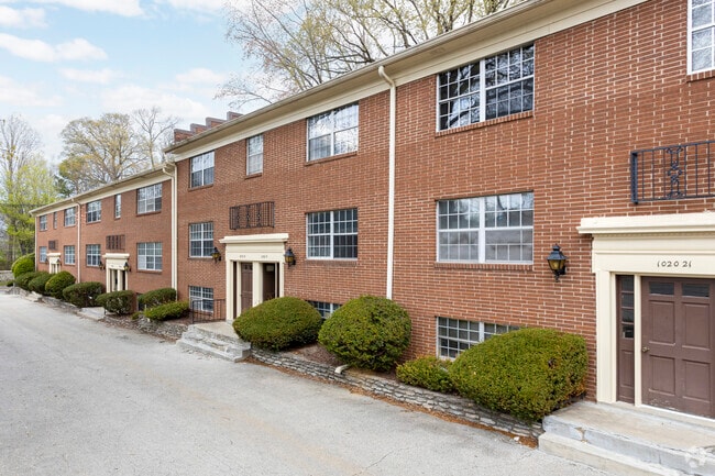
Property Record
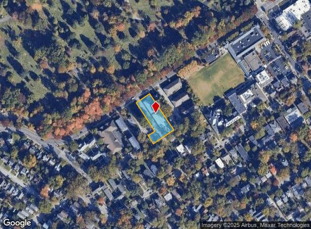
1001 Grinstead Ct, Louisville, KY 40204
NEARBY LISTINGS FOR SALE OR LEASE
Property Detail
1001 Grinstead Ct
075H00390000
Henning & Speeds
Apartment
29600 SQFT SES GRINSTEAD BET WILLOW & RAY 2344
X
Jefferson
21111C0043F
Kentucky
2025
0.68 AC
2025
Cherokee Triangle
008202
Louisville
18,056 SF
Louisville-Jefferson County, KY-IN
DEMOGRAPHICS near 1001 Grinstead Ct
1 Mile
3 Mile
5 Mile
2024 Total Population
13,840
107,286
255,854
2029 Population
13,604
106,452
256,344
Pop Growth 2024-2029
(1.71%)
(0.78%)
+ 0.19%
Average Age
41
41
40
2024 Total Households
7,752
52,980
115,731
HH Growth 2024-2029
(1.72%)
(0.59%)
+ 0.19%
Median Household Inc
$69,776
$56,720
$50,614
Avg Household Size
1.70
1.90
2.10
2024 Avg HH Vehicles
2.00
1.00
1.00
Median Home Value
$357,873
$288,615
$218,990
Median Year Built
1947
1948
1954
Nearby Places
Map Layers
Map Styles
 Street
 Aerial
- Restaurants
- Banks
- Shops
- Fitness
- Groceries
PUBLIC TRANSPORTATION
AIRPORT
Louisville Muhammad Ali International
DRIVE
WALK
Distance
Louisville Muhammad Ali International
16 min
7.7 mi
Freight Ports
Port of Toledo
DRIVE
WALK
Distance
Port of Toledo
355 min
304.8 mi
SALE & LEASE HISTORY
LISTING DATE
SALE/LEASE

Feb 21, 2025
For Sale
Nearby Properties
Address
Land Use
TOTAL SIZE
Lot Size
Zoning
Address
Land Use
TOTAL SIZE
Lot Size
Zoning
4.80 AC
M3-INDUSTR
Address
Land Use
TOTAL SIZE
Lot Size
Zoning
211,050 SF
Address
Land Use
TOTAL SIZE
Lot Size
Zoning
5.40 AC
Address
Land Use
TOTAL SIZE
Lot Size
Zoning
572,868 SF
1.57 AC
Address
Land Use
TOTAL SIZE
Lot Size
Zoning
826,303 SF
2.90 AC
C3-CENTRAL
Address
Land Use
TOTAL SIZE
Lot Size
Zoning
130,724 SF
2.17 AC
Address
Land Use
TOTAL SIZE
Lot Size
Zoning
106,330 SF
9.44 AC
M3-INDUSTR
Address
Land Use
TOTAL SIZE
Lot Size
Zoning
Address
Land Use
TOTAL SIZE
Lot Size
Zoning
4,337 SF
3.71 AC
(C2)COMMER
Address
Land Use
TOTAL SIZE
Lot Size
Zoning
0.56 AC
(C3)CENTRA
Address
Land Use
TOTAL SIZE
Lot Size
Zoning
1,584 SF
4.71 AC
R7-RESIDEN
Address
Land Use
TOTAL SIZE
Lot Size
Zoning
23.42 AC
(W
Address
Land Use
TOTAL SIZE
Lot Size
Zoning
20,449 SF
0.55 AC
C3-CENTRAL
Address
Land Use
TOTAL SIZE
Lot Size
Zoning
2.97 AC
C3-CENTRAL
Address
Land Use
TOTAL SIZE
Lot Size
Zoning
34.06 AC
Address
Land Use
TOTAL SIZE
Lot Size
Zoning
21,767 SF
1.47 AC
EZ1-ENTERP
Address
Land Use
TOTAL SIZE
Lot Size
Zoning
549,563 SF
26.13 AC
OTF-OFFICE
Address
Land Use
TOTAL SIZE
Lot Size
Zoning
304,295 SF
0.60 AC
C3-CENTRAL
Address
Land Use
TOTAL SIZE
Lot Size
Zoning
50,946 SF
2.66 AC
(CM)COMMER
Address
Land Use
TOTAL SIZE
Lot Size
Zoning
34,067 SF
0.84 AC
C3-CENTRAL
Address
Land Use
TOTAL SIZE
Lot Size
Zoning
59,648 SF
1.66 AC
OR3-OFFICE
Address
Land Use
TOTAL SIZE
Lot Size
Zoning
699,568 SF
1.96 AC
(C3)CENTRA
Address
Land Use
TOTAL SIZE
Lot Size
Zoning
12.69 AC
Address
Land Use
TOTAL SIZE
Lot Size
Zoning
228,447 SF
7.70 AC
M2-INDUSTR
Address
Land Use
TOTAL SIZE
Lot Size
Zoning
58,935 SF
1.92 AC
TNZD-TRADI
Address
Land Use
TOTAL SIZE
Lot Size
Zoning
248,323 SF
1 AC
C3-CENTRAL
Address
Land Use
TOTAL SIZE
Lot Size
Zoning
6,254 SF
1.48 AC
C2-COMMERC
Address
Land Use
TOTAL SIZE
Lot Size
Zoning
400 SF
13.92 AC
R6-RESIDEN
Address
Land Use
TOTAL SIZE
Lot Size
Zoning
20,729 SF
0.27 AC
(C3)CENTRA
Address
Land Use
TOTAL SIZE
Lot Size
Zoning
The World's #1 Commercial Real Estate Marketplace
Connect with us
© 2025 CoStar Group
The information above has been obtained from sources believed reliable. While we do not doubt its accuracy we have not verified it and make no guarantee, warranty or representation about it. It is your responsibility to independently confirm its accuracy and completeness. Any projections, opinions, assumptions, or estimates used are for example only and do not represent the current or future performance of the property. The value of this transaction to you depends on tax and other factors which should be evaluated by your tax, financial, and legal advisors. You and your advisors should conduct a careful, independent investigation of the property to determine to your satisfaction the suitability of the property for your needs.