Property Record
1001 Kaizen Pkwy, Savannah, GA 31419
NEARBY LISTINGS FOR SALE OR LEASE
Property Detail
1001 Kaizen Pkwy
Savannah, GA
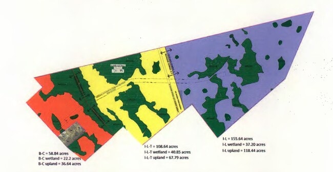
EAST TRACT 1 THE HILL-DURRANCE TRACT
2103401069
Chatham
Residentialacreage
Georgia
2024
85.28 AC
2025
Outlying Chatham County
010806
Savannah
DEMOGRAPHICS near 1001 Kaizen Pkwy
1 Mile
3 Mile
5 Mile
2024 Total Population
1,472
16,300
48,546
2029 Population
1,534
17,044
50,720
Pop Growth 2024-2029
+ 4.21%
+ 4.56%
+ 4.48%
Average Age
37
36
38
2024 Total Households
655
6,247
19,151
HH Growth 2024-2029
+ 4.12%
+ 4.55%
+ 4.42%
Median Household Inc
$67,882
$56,929
$76,739
Avg Household Size
2.20
2.50
2.50
2024 Avg HH Vehicles
1.00
2.00
2.00
Median Home Value
$264,444
$203,032
$236,742
Median Year Built
2006
2005
2003
Nearby Places
Map Layers
Map Styles
 Street
 Aerial
- Restaurants
- Banks
- Shops
- Fitness
- Groceries
PUBLIC TRANSPORTATION
COMMUTER RAIL
Savannah (Palmetto - Amtrak, Silver Meteor - Amtrak, Silver Star - Amtrak)
DRIVE
WALK
Distance
Savannah (Palmetto - Amtrak, Silver Meteor - Amtrak, Silver Star - Amtrak)
15 min
8.5 mi
AIRPORT
Savannah/Hilton Head International
DRIVE
WALK
Distance
Savannah/Hilton Head International
25 min
13.3 mi
Freight Ports
Georgia Ports - Savannah
DRIVE
WALK
Distance
Georgia Ports - Savannah
21 min
12.5 mi
Nearby Properties
Address
Land Use
TOTAL SIZE
Lot Size
Zoning
Address
Land Use
TOTAL SIZE
Lot Size
Zoning
99.50 AC
M
Address
Land Use
TOTAL SIZE
Lot Size
Zoning
19,432 SF
214.77 AC
R3
Address
Land Use
TOTAL SIZE
Lot Size
Zoning
70.49 AC
M
Address
Land Use
TOTAL SIZE
Lot Size
Zoning
942,210 SF
50.60 AC
Address
Land Use
TOTAL SIZE
Lot Size
Zoning
565,144 SF
19.74 AC
I-P
Address
Land Use
TOTAL SIZE
Lot Size
Zoning
34,980 SF
23.34 AC
PR3-16
Address
Land Use
TOTAL SIZE
Lot Size
Zoning
413,230 SF
39.64 AC
M-CO
Address
Land Use
TOTAL SIZE
Lot Size
Zoning
41,592 SF
20.47 AC
PUDC
Address
Land Use
TOTAL SIZE
Lot Size
Zoning
22,728 SF
15.81 AC
PUDC
Address
Land Use
TOTAL SIZE
Lot Size
Zoning
27,168 SF
15.95 AC
PUDC
Address
Land Use
TOTAL SIZE
Lot Size
Zoning
13,920 SF
14.50 AC
RM25
Address
Land Use
TOTAL SIZE
Lot Size
Zoning
16,138 SF
18.33 AC
PUDC
Address
Land Use
TOTAL SIZE
Lot Size
Zoning
27,408 SF
12.97 AC
PUDC
Address
Land Use
TOTAL SIZE
Lot Size
Zoning
10,200 SF
12.79 AC
RM25
Address
Land Use
TOTAL SIZE
Lot Size
Zoning
13,152 SF
11.22 AC
RM25
Address
Land Use
TOTAL SIZE
Lot Size
Zoning
28.95 AC
M
Address
Land Use
TOTAL SIZE
Lot Size
Zoning
71,502 SF
10.60 AC
PUDIS
Address
Land Use
TOTAL SIZE
Lot Size
Zoning
124,110 SF
17.38 AC
PUDB
Address
Land Use
TOTAL SIZE
Lot Size
Zoning
25 AC
R6
Address
Land Use
TOTAL SIZE
Lot Size
Zoning
18,800 SF
8.71 AC
PUDC
Address
Land Use
TOTAL SIZE
Lot Size
Zoning
75,884 SF
3 AC
R3
Address
Land Use
TOTAL SIZE
Lot Size
Zoning
11,784 SF
9.79 AC
PUDC
Address
Land Use
TOTAL SIZE
Lot Size
Zoning
142,560 SF
6.67 AC
PUDCC
Address
Land Use
TOTAL SIZE
Lot Size
Zoning
3,567 SF
24.23 AC
OI-E
Address
Land Use
TOTAL SIZE
Lot Size
Zoning
8,052 SF
6.94 AC
PUDM
Address
Land Use
TOTAL SIZE
Lot Size
Zoning
22,600 SF
7.45 AC
BN
Address
Land Use
TOTAL SIZE
Lot Size
Zoning
88,382 SF
23.16 AC
PUDC
Address
Land Use
TOTAL SIZE
Lot Size
Zoning
8,672 SF
6.06 AC
PR4
Address
Land Use
TOTAL SIZE
Lot Size
Zoning
18,290 SF
8.90 AC
I-P
Address
Land Use
TOTAL SIZE
Lot Size
Zoning
35,304 SF
6.40 AC
PUDC
The World's #1 Commercial Real Estate Marketplace
Connect with us
© 2026 CoStar Group
The information above has been obtained from sources believed reliable. While we do not doubt its accuracy we have not verified it and make no guarantee, warranty or representation about it. It is your responsibility to independently confirm its accuracy and completeness. Any projections, opinions, assumptions, or estimates used are for example only and do not represent the current or future performance of the property. The value of this transaction to you depends on tax and other factors which should be evaluated by your tax, financial, and legal advisors. You and your advisors should conduct a careful, independent investigation of the property to determine to your satisfaction the suitability of the property for your needs.