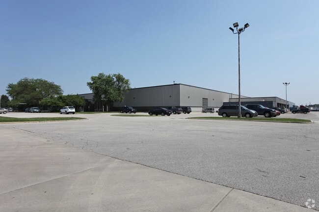
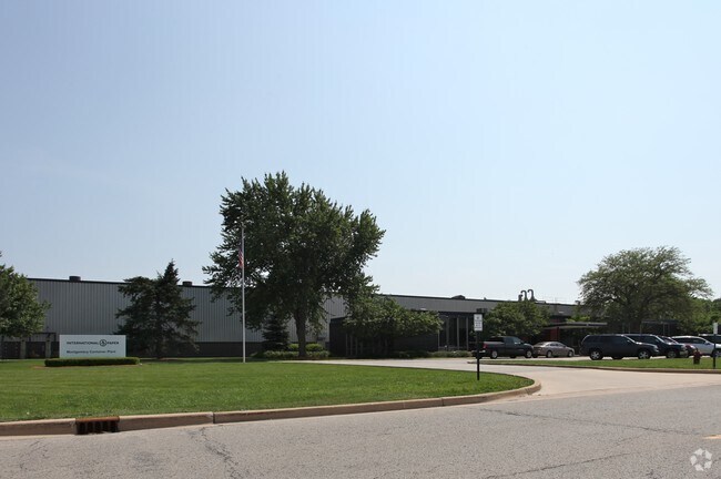
Property Record
1001 Knell St, Montgomery, IL 60538

NEARBY LISTINGS FOR SALE OR LEASE
Property Detail
1001 Knell St
15-32-100-014
PT NW 1/4 SEC 32-38-8 DESC IN BK 2372/613 (EX PT DESC IN DOC 2002K113509 FOR DEDICATED KNELL RD) RANGE CODE: 001
Industrialgeneral
Kane
A
Illinois
17089C0401H
11.88 AC
2024
I-88 West
2024
Chicago
854002
Chicago-Naperville-Elgin, IL-IN-WI
366,503 SF
DEMOGRAPHICS near 1001 Knell St
1 Mile
3 Mile
5 Mile
2024 Total Population
2,492
94,860
202,576
2029 Population
2,538
97,515
209,083
Pop Growth 2024-2029
+ 1.85%
+ 2.80%
+ 3.21%
Average Age
40
37
37
2024 Total Households
940
31,567
66,408
HH Growth 2024-2029
+ 1.70%
+ 2.91%
+ 3.35%
Median Household Inc
$70,744
$71,818
$76,190
Avg Household Size
2.70
2.90
3.00
2024 Avg HH Vehicles
2.00
2.00
2.00
Median Home Value
$196,919
$214,564
$225,975
Median Year Built
1972
1971
1983
Nearby Places
Map Layers
Map Styles
 Street
 Aerial
- Restaurants
- Banks
- Shops
- Fitness
- Groceries
PUBLIC TRANSPORTATION
COMMUTER RAIL
Aurora Station (Burlington Northern-Santa Fe Railway Line - Northeast Illinois Regional Commuter Railroad (Metra))
DRIVE
WALK
Distance
Aurora Station (Burlington Northern-Santa Fe Railway Line - Northeast Illinois Regional Commuter Railroad (Metra))
8 min
3.4 mi
AIRPORT
Chicago O'Hare International
DRIVE
WALK
Distance
Chicago O'Hare International
59 min
41.0 mi
Freight Ports
Port Milwaukee
DRIVE
WALK
Distance
Port Milwaukee
141 min
112.7 mi
Nearby Properties
Address
Land Use
TOTAL SIZE
Lot Size
Zoning
Address
Land Use
TOTAL SIZE
Lot Size
Zoning
19.80 AC
Address
Land Use
TOTAL SIZE
Lot Size
Zoning
296,502 SF
19.01 AC
Address
Land Use
TOTAL SIZE
Lot Size
Zoning
350.78 AC
Address
Land Use
TOTAL SIZE
Lot Size
Zoning
320,874 SF
1.49 AC
Address
Land Use
TOTAL SIZE
Lot Size
Zoning
989,724 SF
49.41 AC
Address
Land Use
TOTAL SIZE
Lot Size
Zoning
56.02 AC
Address
Land Use
TOTAL SIZE
Lot Size
Zoning
218,020 SF
21.35 AC
Address
Land Use
TOTAL SIZE
Lot Size
Zoning
169,918 SF
20 AC
Address
Land Use
TOTAL SIZE
Lot Size
Zoning
100,340 SF
1.80 AC
Address
Land Use
TOTAL SIZE
Lot Size
Zoning
428,544 SF
41.38 AC
Address
Land Use
TOTAL SIZE
Lot Size
Zoning
73,880 SF
0.75 AC
Address
Land Use
TOTAL SIZE
Lot Size
Zoning
97,136 SF
6.08 AC
Address
Land Use
TOTAL SIZE
Lot Size
Zoning
9.86 AC
Address
Land Use
TOTAL SIZE
Lot Size
Zoning
259,140 SF
18.05 AC
Address
Land Use
TOTAL SIZE
Lot Size
Zoning
136,900 SF
3.63 AC
Address
Land Use
TOTAL SIZE
Lot Size
Zoning
56.13 AC
Address
Land Use
TOTAL SIZE
Lot Size
Zoning
217,505 SF
17.50 AC
Address
Land Use
TOTAL SIZE
Lot Size
Zoning
3.85 AC
Address
Land Use
TOTAL SIZE
Lot Size
Zoning
70,780 SF
10.91 AC
Address
Land Use
TOTAL SIZE
Lot Size
Zoning
581,048 SF
37.29 AC
Address
Land Use
TOTAL SIZE
Lot Size
Zoning
34,822 SF
136.74 AC
Address
Land Use
TOTAL SIZE
Lot Size
Zoning
17.35 AC
Address
Land Use
TOTAL SIZE
Lot Size
Zoning
108,589 SF
0.10 AC
Address
Land Use
TOTAL SIZE
Lot Size
Zoning
2.58 AC
Address
Land Use
TOTAL SIZE
Lot Size
Zoning
60,275 SF
3 AC
Address
Land Use
TOTAL SIZE
Lot Size
Zoning
287,902 SF
3.31 AC
Address
Land Use
TOTAL SIZE
Lot Size
Zoning
91,764 SF
5.86 AC
Address
Land Use
TOTAL SIZE
Lot Size
Zoning
146,500 SF
8.65 AC
Address
Land Use
TOTAL SIZE
Lot Size
Zoning
84,870 SF
5.28 AC
The World's #1 Commercial Real Estate Marketplace
Connect with us
© 2025 CoStar Group
The information above has been obtained from sources believed reliable. While we do not doubt its accuracy we have not verified it and make no guarantee, warranty or representation about it. It is your responsibility to independently confirm its accuracy and completeness. Any projections, opinions, assumptions, or estimates used are for example only and do not represent the current or future performance of the property. The value of this transaction to you depends on tax and other factors which should be evaluated by your tax, financial, and legal advisors. You and your advisors should conduct a careful, independent investigation of the property to determine to your satisfaction the suitability of the property for your needs.