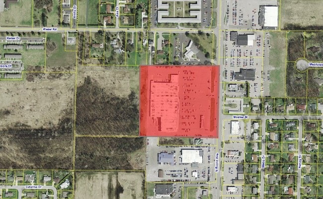
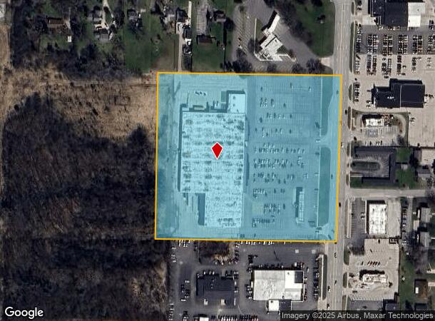
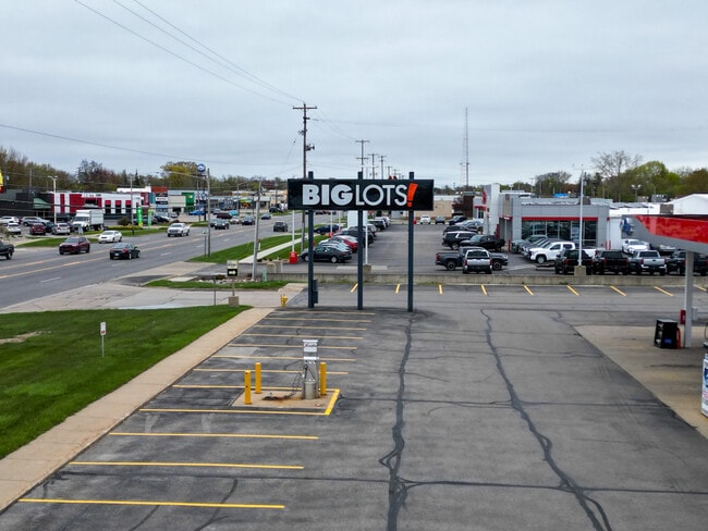
Property Record
1001 N Euclid Ave, Bay City, MI 48706
NEARBY LISTINGS FOR SALE OR LEASE
Property Detail
1001 N Euclid Ave
09-010-018-400-070-00
COM 330 FT S OF E 1/4 POST TH S 660 FT TH W 720 FT TH N 660 FT TH E 720 FT TO BEG PT OF NE 1/4 OF SE 1/4 SEC 18 T14N R5E
Commercialnec
Bay
X
Michigan
26145C0075E
10.91 AC
2024
Midland/Flint
2025
Other Market Areas
285800
Bay City, MI
107,921 SF
DEMOGRAPHICS near 1001 N Euclid Ave
1 Mile
3 Mile
5 Mile
2024 Total Population
7,546
43,528
69,573
2029 Population
7,422
43,116
68,934
Pop Growth 2024-2029
(1.64%)
(0.95%)
(0.92%)
Average Age
43
42
43
2024 Total Households
3,369
19,158
30,683
HH Growth 2024-2029
(1.81%)
(1.02%)
(0.94%)
Median Household Inc
$53,278
$49,707
$51,866
Avg Household Size
2.20
2.20
2.20
2024 Avg HH Vehicles
2.00
2.00
2.00
Median Home Value
$107,710
$89,263
$97,757
Median Year Built
1960
1954
1956
Nearby Places
- Restaurants
- Banks
- Shops
- Fitness
- Groceries
PUBLIC TRANSPORTATION
AIRPORT
MBS International
DRIVE
WALK
Distance
MBS International
22 min
14.5 mi
Freight Ports
Port of Toledo
DRIVE
WALK
Distance
Port of Toledo
183 min
159.2 mi
Nearby Properties
Address
Land Use
TOTAL SIZE
Lot Size
Zoning
Address
Land Use
TOTAL SIZE
Lot Size
Zoning
97,304 SF
3.61 AC
C-3 CTRL B
Address
Land Use
TOTAL SIZE
Lot Size
Zoning
536,802 SF
450 AC
I-2
Address
Land Use
TOTAL SIZE
Lot Size
Zoning
164,241 SF
10.08 AC
RM-1
Address
Land Use
TOTAL SIZE
Lot Size
Zoning
16.52 AC
R-3
Address
Land Use
TOTAL SIZE
Lot Size
Zoning
279,395 SF
192 AC
I-2
Address
Land Use
TOTAL SIZE
Lot Size
Zoning
167,100 SF
35.59 AC
M-2 GEN IN
Address
Land Use
TOTAL SIZE
Lot Size
Zoning
60,200 SF
9.50 AC
C-3 CTRL B
Address
Land Use
TOTAL SIZE
Lot Size
Zoning
169,440 SF
16.54 AC
RM-1
Address
Land Use
TOTAL SIZE
Lot Size
Zoning
1.87 AC
C-3 CTRL B
Address
Land Use
TOTAL SIZE
Lot Size
Zoning
57,000 SF
1.09 AC
C-3 CTRL B
Address
Land Use
TOTAL SIZE
Lot Size
Zoning
41,011 SF
8.28 AC
C-2
Address
Land Use
TOTAL SIZE
Lot Size
Zoning
50,965 SF
0.83 AC
C-3 CTRL B
Address
Land Use
TOTAL SIZE
Lot Size
Zoning
22,356 SF
I-2
Address
Land Use
TOTAL SIZE
Lot Size
Zoning
39,417 SF
0.23 AC
C-3 CTRL B
Address
Land Use
TOTAL SIZE
Lot Size
Zoning
63,200 SF
1.97 AC
C-3 CTRL B
Address
Land Use
TOTAL SIZE
Lot Size
Zoning
C-3 CTRL B
Address
Land Use
TOTAL SIZE
Lot Size
Zoning
45,072 SF
4.81 AC
C-2B HWY B
Address
Land Use
TOTAL SIZE
Lot Size
Zoning
156,600 SF
9.11 AC
M-1 LT IND
Address
Land Use
TOTAL SIZE
Lot Size
Zoning
7,200 SF
0.69 AC
C-3 CTRL B
Address
Land Use
TOTAL SIZE
Lot Size
Zoning
139,237 SF
5.47 AC
C-3 CTRL B
Address
Land Use
TOTAL SIZE
Lot Size
Zoning
163,673 SF
17.85 AC
RM-1
Address
Land Use
TOTAL SIZE
Lot Size
Zoning
Address
Land Use
TOTAL SIZE
Lot Size
Zoning
85,264 SF
5 AC
RM-1
Address
Land Use
TOTAL SIZE
Lot Size
Zoning
32.23 AC
C
Address
Land Use
TOTAL SIZE
Lot Size
Zoning
36,243 SF
3.41 AC
C-2
Address
Land Use
TOTAL SIZE
Lot Size
Zoning
109,649 SF
11.29 AC
C-2
Address
Land Use
TOTAL SIZE
Lot Size
Zoning
60,889 SF
Address
Land Use
TOTAL SIZE
Lot Size
Zoning
58,981 SF
3.09 AC
C
Address
Land Use
TOTAL SIZE
Lot Size
Zoning
472,836 SF
33.72 AC
C-2
The World's #1 Commercial Real Estate Marketplace
Connect with us
© 2025 CoStar Group
The information above has been obtained from sources believed reliable. While we do not doubt its accuracy we have not verified it and make no guarantee, warranty or representation about it. It is your responsibility to independently confirm its accuracy and completeness. Any projections, opinions, assumptions, or estimates used are for example only and do not represent the current or future performance of the property. The value of this transaction to you depends on tax and other factors which should be evaluated by your tax, financial, and legal advisors. You and your advisors should conduct a careful, independent investigation of the property to determine to your satisfaction the suitability of the property for your needs.