Property Record
1001 N Splitrock Blvd, Brandon, SD 57005
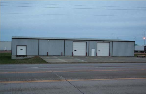

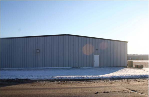

Property Detail
1001 N Splitrock Blvd
57634
LOT F (EX S74`) TRACT 2 BURKMAN INDUSTRIAL PARK ADDN TO CITY OF BRANDON
Warehouse
Minnehaha
I3;INDUSTR
South Dakota
B and X Area of moderate flood hazard, usually the area between the limits of the 100-year and 500-year floods.
f
2024
0.95 AC
2024
Sioux Falls
010501
Other Market Areas
10,000 SF
Sioux Falls, SD-MN
NEARBY LISTINGS FOR SALE OR LEASE
-
-
View all Brandon listings for sale on LoopNet.com
DEMOGRAPHICS near 1001 N Splitrock Blvd
1 mile
3 mile
5 mile
2024 Total Population
4,025
12,161
15,202
2029 Population
4,231
12,792
16,087
Pop Growth 2024-2029
+ 5.12%
+ 5.19%
+ 5.82%
Average Age
38
37
37
2024 Total Households
1,493
4,329
5,356
HH Growth 2024-2029
+ 5.56%
+ 5.57%
+ 6.18%
Median Household Inc
$97,892
$106,385
$112,402
Avg Household Size
2.60
2.80
2.80
2024 Avg HH Vehicles
2.00
2.00
2.00
Median Home Value
$349,740
$355,701
$372,860
Median Year Built
2000
2000
2001
Nearby Places
Map Layers
Map Styles
 Street
 Aerial
Transit
 Traffic
 Biking
Places
Listings with unknown addresses are not visible on the map
- Restaurants
- Banks
- Shops
- Fitness
- Groceries
PUBLIC TRANSPORTATION
AIRPORT
Joe Foss Field
Drive
Walk
Distance
Joe Foss Field
14 min
10.0 mi
Nearby Properties
Address
Land Use
TOTAL SIZE
Lot Size
Zoning
Address
Land Use
TOTAL SIZE
Lot Size
Zoning
43.83 AC
Address
Land Use
TOTAL SIZE
Lot Size
Zoning
6,564 SF
15.96 AC
Address
Land Use
TOTAL SIZE
Lot Size
Zoning
37,016 SF
5.29 AC
Address
Land Use
TOTAL SIZE
Lot Size
Zoning
20.57 AC
Address
Land Use
TOTAL SIZE
Lot Size
Zoning
8,348 SF
3.36 AC
I3;INDUSTR
Address
Land Use
TOTAL SIZE
Lot Size
Zoning
76,250 SF
11.01 AC
Address
Land Use
TOTAL SIZE
Lot Size
Zoning
56,160 SF
4.72 AC
Address
Land Use
TOTAL SIZE
Lot Size
Zoning
129,740 SF
6.45 AC
I3;INDUSTR
Address
Land Use
TOTAL SIZE
Lot Size
Zoning
1,200 SF
28.70 AC
I2
Address
Land Use
TOTAL SIZE
Lot Size
Zoning
52,056 SF
2 AC
Address
Land Use
TOTAL SIZE
Lot Size
Zoning
44,493 SF
2.26 AC
Address
Land Use
TOTAL SIZE
Lot Size
Zoning
4,268 SF
45.53 AC
A1
Address
Land Use
TOTAL SIZE
Lot Size
Zoning
1,344 SF
7.66 AC
Address
Land Use
TOTAL SIZE
Lot Size
Zoning
38,112 SF
12.42 AC
Address
Land Use
TOTAL SIZE
Lot Size
Zoning
22,757 SF
6.30 AC
Address
Land Use
TOTAL SIZE
Lot Size
Zoning
49,071 SF
1.67 AC
B2;RETAILF
Address
Land Use
TOTAL SIZE
Lot Size
Zoning
36,148 SF
9.03 AC
Address
Land Use
TOTAL SIZE
Lot Size
Zoning
25,196 SF
5.58 AC
Address
Land Use
TOTAL SIZE
Lot Size
Zoning
47,782 SF
4 AC
Address
Land Use
TOTAL SIZE
Lot Size
Zoning
33,792 SF
10 AC
RC;CONSERV
Address
Land Use
TOTAL SIZE
Lot Size
Zoning
43,973 SF
1.14 AC
R1;SINGLE
Address
Land Use
TOTAL SIZE
Lot Size
Zoning
40,800 SF
6.67 AC
Address
Land Use
TOTAL SIZE
Lot Size
Zoning
5,888 SF
33.65 AC
I2
Address
Land Use
TOTAL SIZE
Lot Size
Zoning
32,000 SF
2.98 AC
Address
Land Use
TOTAL SIZE
Lot Size
Zoning
8,944 SF
2.44 AC
Address
Land Use
TOTAL SIZE
Lot Size
Zoning
2,014 SF
3.73 AC
Address
Land Use
TOTAL SIZE
Lot Size
Zoning
32,640 SF
2.57 AC
Address
Land Use
TOTAL SIZE
Lot Size
Zoning
22,866 SF
1.65 AC
Address
Land Use
TOTAL SIZE
Lot Size
Zoning
8,344 SF
1.41 AC
Address
Land Use
TOTAL SIZE
Lot Size
Zoning
7,999 SF
0.92 AC
RC;CONSERV
The World's #1 Commercial Real Estate Marketplace
Connect with us
© 2026 CoStar Group
The information above has been obtained from sources believed reliable. While we do not doubt its accuracy we have not verified it and make no guarantee, warranty or representation about it. It is your responsibility to independently confirm its accuracy and completeness. Any projections, opinions, assumptions, or estimates used are for example only and do not represent the current or future performance of the property. The value of this transaction to you depends on tax and other factors which should be evaluated by your tax, financial, and legal advisors. You and your advisors should conduct a careful, independent investigation of the property to determine to your satisfaction the suitability of the property for your needs.