Property Record
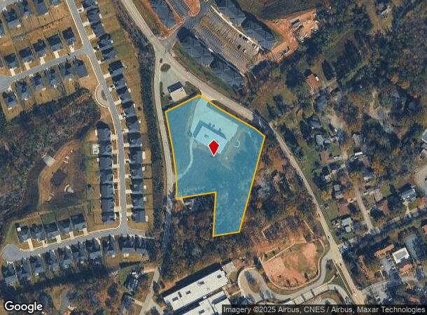
1001 Reid School Rd, Taylors, SC 29687
NEARBY LISTINGS FOR SALE OR LEASE
Property Detail
1001 Reid School Rd
Greenville-Anderson-Greer, SC
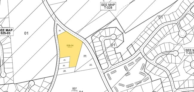
Boundary Survey For Middlehouse Investme
T029.02-01-008.04
MAP T029.02
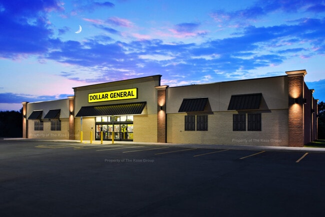
Wholesaleoutletdiscountstore
Greenville
X
South Carolina
45045C0337E
008.04
2024
4.53 AC
2024
Wade Hampton
002704
Greenville/Spartanburg
DEMOGRAPHICS near 1001 Reid School Rd
1 Mile
3 Mile
5 Mile
2024 Total Population
6,155
37,360
106,165
2029 Population
6,766
40,963
116,347
Pop Growth 2024-2029
+ 9.93%
+ 9.64%
+ 9.59%
Average Age
39
41
40
2024 Total Households
2,493
14,794
42,718
HH Growth 2024-2029
+ 10.03%
+ 9.73%
+ 9.66%
Median Household Inc
$66,600
$65,550
$71,883
Avg Household Size
2.50
2.50
2.40
2024 Avg HH Vehicles
2.00
2.00
2.00
Median Home Value
$233,572
$230,200
$256,462
Median Year Built
1983
1982
1984
Nearby Places
Map Layers
Map Styles
 Street
 Aerial
- Restaurants
- Banks
- Shops
- Fitness
- Groceries
PUBLIC TRANSPORTATION
COMMUTER RAIL
Greenville Amtrak Station (Crescent - Amtrak)
DRIVE
WALK
Distance
Greenville Amtrak Station (Crescent - Amtrak)
17 min
8.6 mi
AIRPORT
Greenville Spartanburg International
DRIVE
WALK
Distance
Greenville Spartanburg International
25 min
11.6 mi
Freight Ports
North Charleston Terminal
DRIVE
WALK
Distance
North Charleston Terminal
239 min
207.0 mi
SALE & LEASE HISTORY
LISTING DATE
SALE/LEASE

Sep 22, 2020
For Sale
Aug 10, 2020
For Sale
Nearby Properties
Address
Land Use
TOTAL SIZE
Lot Size
Zoning
Address
Land Use
TOTAL SIZE
Lot Size
Zoning
11.80 AC
R10
Address
Land Use
TOTAL SIZE
Lot Size
Zoning
11.30 AC
R10
Address
Land Use
TOTAL SIZE
Lot Size
Zoning
8.95 AC
OD
Address
Land Use
TOTAL SIZE
Lot Size
Zoning
41.90 AC
RMA
Address
Land Use
TOTAL SIZE
Lot Size
Zoning
3.40 AC
C2
Address
Land Use
TOTAL SIZE
Lot Size
Zoning
3.50 AC
C2
Address
Land Use
TOTAL SIZE
Lot Size
Zoning
1.20 AC
I1
Address
Land Use
TOTAL SIZE
Lot Size
Zoning
3.70 AC
C2
Address
Land Use
TOTAL SIZE
Lot Size
Zoning
8.10 AC
I1
Address
Land Use
TOTAL SIZE
Lot Size
Zoning
6.10 AC
C2
Address
Land Use
TOTAL SIZE
Lot Size
Zoning
1.03 AC
RM
Address
Land Use
TOTAL SIZE
Lot Size
Zoning
82.10 AC
S1
Address
Land Use
TOTAL SIZE
Lot Size
Zoning
14.78 AC
I1
Address
Land Use
TOTAL SIZE
Lot Size
Zoning
5.21 AC
C2
Address
Land Use
TOTAL SIZE
Lot Size
Zoning
9.14 AC
R75
Address
Land Use
TOTAL SIZE
Lot Size
Zoning
3.11 AC
I1
Address
Land Use
TOTAL SIZE
Lot Size
Zoning
12 AC
RM
Address
Land Use
TOTAL SIZE
Lot Size
Zoning
12.30 AC
I1
Address
Land Use
TOTAL SIZE
Lot Size
Zoning
2,323 SF
23.11 AC
R20
Address
Land Use
TOTAL SIZE
Lot Size
Zoning
1.70 AC
R75
Address
Land Use
TOTAL SIZE
Lot Size
Zoning
17.32 AC
C3
Address
Land Use
TOTAL SIZE
Lot Size
Zoning
2,194 SF
56.43 AC
S1
Address
Land Use
TOTAL SIZE
Lot Size
Zoning
5.05 AC
C2
Address
Land Use
TOTAL SIZE
Lot Size
Zoning
20.63 AC
C2
Address
Land Use
TOTAL SIZE
Lot Size
Zoning
11 AC
RM
Address
Land Use
TOTAL SIZE
Lot Size
Zoning
1.93 AC
R20
Address
Land Use
TOTAL SIZE
Lot Size
Zoning
17.22 AC
I1
Address
Land Use
TOTAL SIZE
Lot Size
Zoning
36.04 AC
R20
Address
Land Use
TOTAL SIZE
Lot Size
Zoning
3.60 AC
R20
Address
Land Use
TOTAL SIZE
Lot Size
Zoning
10 AC
I1
The World's #1 Commercial Real Estate Marketplace
Connect with us
© 2026 CoStar Group
The information above has been obtained from sources believed reliable. While we do not doubt its accuracy we have not verified it and make no guarantee, warranty or representation about it. It is your responsibility to independently confirm its accuracy and completeness. Any projections, opinions, assumptions, or estimates used are for example only and do not represent the current or future performance of the property. The value of this transaction to you depends on tax and other factors which should be evaluated by your tax, financial, and legal advisors. You and your advisors should conduct a careful, independent investigation of the property to determine to your satisfaction the suitability of the property for your needs.