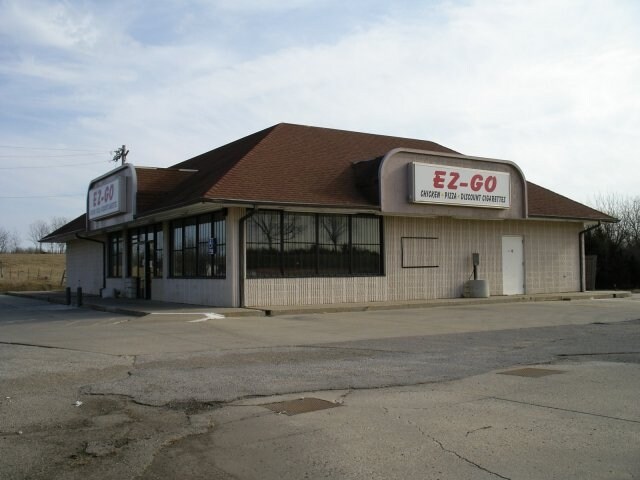
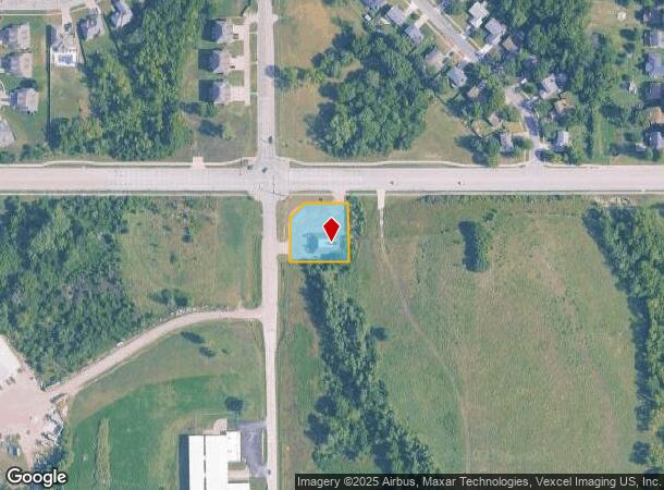
Property Record
1001 Se 45Th St, Topeka, KS 66609
NEARBY LISTINGS FOR SALE OR LEASE
Property Detail
1001 Se 45Th St
Topeka, KS
Roenbaugh Place Sub
139-29-0-20-01-003-000
ROENBAUGH PLACE SUB, S29, T12, R16, BLOCK A, LOT 1, BLK A LT 1 ROENBAUGH PLACE LESS ROW SECTION 29 TOWNSHIP 12 RANGE 16
Officebuilding
Shawnee
X
Kansas
20177C0306E
1
2024
0.60 AC
2025
Topeka
003702
Kansas City
3,500 SF
DEMOGRAPHICS near 1001 Se 45Th St
1 Mile
3 Mile
5 Mile
2024 Total Population
4,538
32,001
95,838
2029 Population
4,473
31,783
95,388
Pop Growth 2024-2029
(1.43%)
(0.68%)
(0.47%)
Average Age
40
39
39
2024 Total Households
1,796
12,787
39,028
HH Growth 2024-2029
(1.45%)
(0.70%)
(0.48%)
Median Household Inc
$59,890
$49,627
$49,837
Avg Household Size
2.50
2.40
2.30
2024 Avg HH Vehicles
2.00
2.00
2.00
Median Home Value
$132,177
$114,524
$122,527
Median Year Built
1991
1970
1967
Nearby Places
Map Layers
Map Styles
 Street
 Aerial
- Restaurants
- Banks
- Shops
- Fitness
- Groceries
PUBLIC TRANSPORTATION
COMMUTER RAIL
DRIVE
WALK
Distance
10 min
5.1 mi
Nearby Properties
Address
Land Use
TOTAL SIZE
Lot Size
Zoning
Address
Land Use
TOTAL SIZE
Lot Size
Zoning
77,776 SF
10.64 AC
PUD,M2,R1,
Address
Land Use
TOTAL SIZE
Lot Size
Zoning
19,120 SF
2.08 AC
R1
Address
Land Use
TOTAL SIZE
Lot Size
Zoning
797,582 SF
384.32 AC
I1,I2
Address
Land Use
TOTAL SIZE
Lot Size
Zoning
152,049 SF
25.61 AC
R1
Address
Land Use
TOTAL SIZE
Lot Size
Zoning
103,285 SF
16.99 AC
I1,PUD
Address
Land Use
TOTAL SIZE
Lot Size
Zoning
1,351,980 SF
141.63 AC
I1
Address
Land Use
TOTAL SIZE
Lot Size
Zoning
165,001 SF
24.83 AC
R1
Address
Land Use
TOTAL SIZE
Lot Size
Zoning
52,261 SF
4.59 AC
OI3
Address
Land Use
TOTAL SIZE
Lot Size
Zoning
161,335 SF
37.32 AC
R1
Address
Land Use
TOTAL SIZE
Lot Size
Zoning
100,954 SF
77.35 AC
R1
Address
Land Use
TOTAL SIZE
Lot Size
Zoning
50,453 SF
14.29 AC
PUD,M2
Address
Land Use
TOTAL SIZE
Lot Size
Zoning
1,250 SF
630.34 AC
RR1
Address
Land Use
TOTAL SIZE
Lot Size
Zoning
156,628 SF
44.05 AC
I1
Address
Land Use
TOTAL SIZE
Lot Size
Zoning
465,600 SF
52.91 AC
I1
Address
Land Use
TOTAL SIZE
Lot Size
Zoning
40,321 SF
5.69 AC
I1
Address
Land Use
TOTAL SIZE
Lot Size
Zoning
38,858 SF
1.01 AC
R1
Address
Land Use
TOTAL SIZE
Lot Size
Zoning
188,358 SF
183.64 AC
I1,RR1
Address
Land Use
TOTAL SIZE
Lot Size
Zoning
56,485 SF
11.58 AC
I1
Address
Land Use
TOTAL SIZE
Lot Size
Zoning
15,893 SF
0.64 AC
R1
Address
Land Use
TOTAL SIZE
Lot Size
Zoning
4.81 AC
Address
Land Use
TOTAL SIZE
Lot Size
Zoning
38,866 SF
9.40 AC
R1
Address
Land Use
TOTAL SIZE
Lot Size
Zoning
3,525 SF
1.89 AC
C3
Address
Land Use
TOTAL SIZE
Lot Size
Zoning
44,619 SF
4.35 AC
R1,R2
Address
Land Use
TOTAL SIZE
Lot Size
Zoning
14,650 SF
3.64 AC
M2,R1
Address
Land Use
TOTAL SIZE
Lot Size
Zoning
40,591 SF
6.19 AC
R1
Address
Land Use
TOTAL SIZE
Lot Size
Zoning
43,476 SF
8.96 AC
M1
Address
Land Use
TOTAL SIZE
Lot Size
Zoning
89,377 SF
11.06 AC
I2
Address
Land Use
TOTAL SIZE
Lot Size
Zoning
158,711 SF
27.34 AC
C4,M2,R1
Address
Land Use
TOTAL SIZE
Lot Size
Zoning
35,832 SF
7.55 AC
R1
Address
Land Use
TOTAL SIZE
Lot Size
Zoning
207,235 SF
22.74 AC
C3
The World's #1 Commercial Real Estate Marketplace
Connect with us
© 2025 CoStar Group
The information above has been obtained from sources believed reliable. While we do not doubt its accuracy we have not verified it and make no guarantee, warranty or representation about it. It is your responsibility to independently confirm its accuracy and completeness. Any projections, opinions, assumptions, or estimates used are for example only and do not represent the current or future performance of the property. The value of this transaction to you depends on tax and other factors which should be evaluated by your tax, financial, and legal advisors. You and your advisors should conduct a careful, independent investigation of the property to determine to your satisfaction the suitability of the property for your needs.