Property Record
1001 Sutton Rd, Streamwood, IL 60107
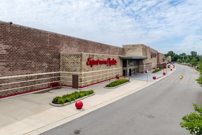

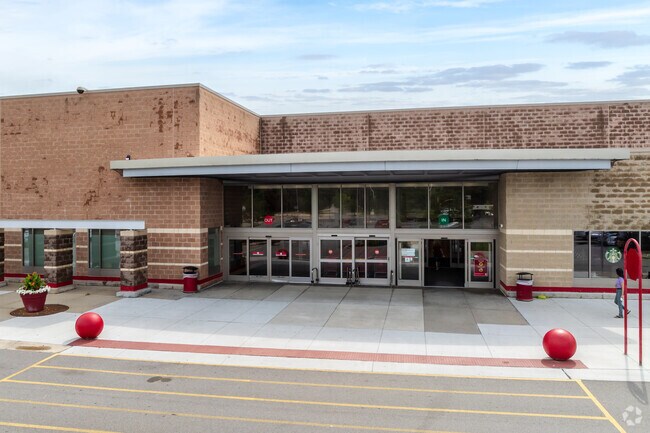
Property Detail
1001 Sutton Rd
06-22-302-013-0000
Cook
Commercialbuilding
Illinois
B and X Area of moderate flood hazard, usually the area between the limits of the 100-year and 500-year floods.
12.85 AC
2023
Far Northwest
2025
Chicago
804506
Chicago-Naperville-Elgin, IL-IN
167,166 SF
NEARBY LISTINGS FOR SALE OR LEASE
DEMOGRAPHICS near 1001 Sutton Rd
1 mile
3 mile
5 mile
2025 Total Population
12,108
83,707
225,795
2030 Population
12,100
83,947
226,632
Pop Growth 2025-2030
(0.07%)
+ 0.29%
+ 0.37%
Average Age
42
40
40
2025 Total Households
4,216
28,081
76,586
HH Growth 2025-2030
(0.28%)
+ 0.08%
+ 0.21%
Median Household Inc
$119,309
$98,874
$95,889
Avg Household Size
2.80
2.90
2.80
2025 Avg HH Vehicles
2.00
2.00
2.00
Median Home Value
$320,771
$280,938
$285,170
Median Year Built
1992
1983
1978
Nearby Places
Map Layers
Map Styles
 Street
 Aerial
Layers
 Traffic
 Biking
Places
Listings with unknown addresses are not visible on the map
- Restaurants
- Banks
- Shops
- Fitness
- Groceries
PUBLIC TRANSPORTATION
COMMUTER RAIL
Bartlett Station (Milwaukee District West Line - Northeast Illinois Regional Commuter Railroad (Metra))
Drive
Walk
Distance
Bartlett Station (Milwaukee District West Line - Northeast Illinois Regional Commuter Railroad (Metra))
6 min
2.9 mi
Hanover Park Station (Milwaukee District West Line - Northeast Illinois Regional Commuter Railroad (Metra))
Drive
Walk
Distance
Hanover Park Station (Milwaukee District West Line - Northeast Illinois Regional Commuter Railroad (Metra))
7 min
4.3 mi
AIRPORT
Chicago O'Hare International
Drive
Walk
Distance
Chicago O'Hare International
32 min
24.1 mi
Chicago Midway International
Drive
Walk
Distance
Chicago Midway International
50 min
33.3 mi
Nearby Properties
Address
Land Use
TOTAL SIZE
Lot Size
Zoning
Address
Land Use
TOTAL SIZE
Lot Size
Zoning
51,091 SF
3.52 AC
Address
Land Use
TOTAL SIZE
Lot Size
Zoning
38.13 AC
Address
Land Use
TOTAL SIZE
Lot Size
Zoning
421,722 SF
34.61 AC
Address
Land Use
TOTAL SIZE
Lot Size
Zoning
400,000 SF
31.67 AC
I
Address
Land Use
TOTAL SIZE
Lot Size
Zoning
328,208 SF
5.62 AC
Address
Land Use
TOTAL SIZE
Lot Size
Zoning
130,923 SF
13.15 AC
Address
Land Use
TOTAL SIZE
Lot Size
Zoning
300,000 SF
16.56 AC
I
Address
Land Use
TOTAL SIZE
Lot Size
Zoning
30,000 SF
1.04 AC
Address
Land Use
TOTAL SIZE
Lot Size
Zoning
94,497 SF
9.43 AC
C
Address
Land Use
TOTAL SIZE
Lot Size
Zoning
401,250 SF
73.98 AC
Address
Land Use
TOTAL SIZE
Lot Size
Zoning
64,182 SF
2.62 AC
Address
Land Use
TOTAL SIZE
Lot Size
Zoning
207,000 SF
11.72 AC
Address
Land Use
TOTAL SIZE
Lot Size
Zoning
348,500 SF
23.57 AC
Address
Land Use
TOTAL SIZE
Lot Size
Zoning
179,497 SF
12.33 AC
Address
Land Use
TOTAL SIZE
Lot Size
Zoning
436,500 SF
Address
Land Use
TOTAL SIZE
Lot Size
Zoning
209,628 SF
11.44 AC
Address
Land Use
TOTAL SIZE
Lot Size
Zoning
423,726 SF
35.97 AC
Address
Land Use
TOTAL SIZE
Lot Size
Zoning
186,000 SF
10.50 AC
Address
Land Use
TOTAL SIZE
Lot Size
Zoning
Address
Land Use
TOTAL SIZE
Lot Size
Zoning
11,132 SF
2 AC
Address
Land Use
TOTAL SIZE
Lot Size
Zoning
3,205 SF
2.35 AC
Address
Land Use
TOTAL SIZE
Lot Size
Zoning
167,449 SF
11.15 AC
Address
Land Use
TOTAL SIZE
Lot Size
Zoning
462,984 SF
19 AC
Address
Land Use
TOTAL SIZE
Lot Size
Zoning
293,632 SF
Address
Land Use
TOTAL SIZE
Lot Size
Zoning
123,484 SF
7.92 AC
Address
Land Use
TOTAL SIZE
Lot Size
Zoning
86,781 SF
8.80 AC
C
Address
Land Use
TOTAL SIZE
Lot Size
Zoning
Address
Land Use
TOTAL SIZE
Lot Size
Zoning
133,320 SF
14.51 AC
Address
Land Use
TOTAL SIZE
Lot Size
Zoning
The World's #1 Commercial Real Estate Marketplace
Connect with us
© 2026 CoStar Group
The information above has been obtained from sources believed reliable. While we do not doubt its accuracy we have not verified it and make no guarantee, warranty or representation about it. It is your responsibility to independently confirm its accuracy and completeness. Any projections, opinions, assumptions, or estimates used are for example only and do not represent the current or future performance of the property. The value of this transaction to you depends on tax and other factors which should be evaluated by your tax, financial, and legal advisors. You and your advisors should conduct a careful, independent investigation of the property to determine to your satisfaction the suitability of the property for your needs.