Property Record
1001 Technology Dr, West Columbia, SC 29170

Save to a Folder
{{folder.Name}}
{{folder.ListingIds.length}} Properties
{{folder.ListingIds.length}} Property
Create a New Folder
Property Detail
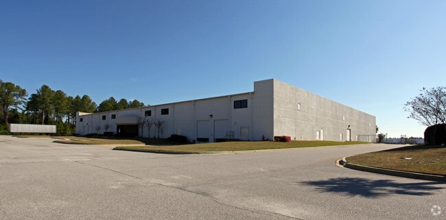
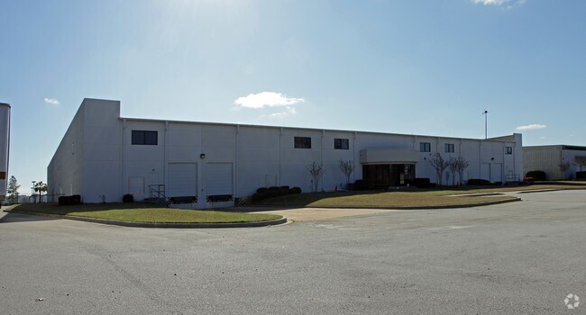
1001 Technology Dr
005698-03-021
PARCELS A & B
Publicstorage
Lexington
ID
South Carolina
B and X Area of moderate flood hazard, usually the area between the limits of the 100-year and 500-year floods.
5.90 AC
2025
Cayce/West Columbia
2025
Columbia
980100
Columbia, SC
54,092 SF
NEARBY LISTINGS FOR SALE OR LEASE
DEMOGRAPHICS near 1001 Technology Dr
1 mile
3 mile
5 mile
2025 Total Population
1,699
28,087
87,827
2030 Population
1,796
29,243
91,892
Pop Growth 2025-2030
+ 5.71%
+ 4.12%
+ 4.63%
Average Age
40
41
41
2025 Total Households
709
11,621
36,860
HH Growth 2025-2030
+ 5.78%
+ 4.33%
+ 4.82%
Median Household Inc
$68,667
$73,488
$69,292
Avg Household Size
2.40
2.40
2.30
2025 Avg HH Vehicles
2.00
2.00
2.00
Median Home Value
$209,893
$198,330
$212,438
Median Year Built
1977
1986
1987
Nearby Places
Map Layers
Map Styles
 Street
 Aerial
Layers
 Traffic
 Biking
Places
Listings with unknown addresses are not visible on the map
- Restaurants
- Banks
- Shops
- Fitness
- Groceries
PUBLIC TRANSPORTATION
COMMUTER RAIL
Columbia Amtrak Station (Silver Star - Amtrak)
Drive
Walk
Distance
Columbia Amtrak Station (Silver Star - Amtrak)
13 min
7.3 mi
AIRPORT
Columbia Metro
Drive
Walk
Distance
Columbia Metro
15 min
4.1 mi
Freight Ports
North Charleston Terminal
Drive
Walk
Distance
North Charleston Terminal
119 min
104.0 mi
Nearby Properties
Address
Land Use
TOTAL SIZE
Lot Size
Zoning
Address
Land Use
TOTAL SIZE
Lot Size
Zoning
461,888 SF
61.50 AC
ID
Address
Land Use
TOTAL SIZE
Lot Size
Zoning
3,614 SF
1,444.32 AC
ID
Address
Land Use
TOTAL SIZE
Lot Size
Zoning
10,304 SF
11.89 AC
R1
Address
Land Use
TOTAL SIZE
Lot Size
Zoning
58.81 AC
RD
Address
Land Use
TOTAL SIZE
Lot Size
Zoning
257,688 SF
23.03 AC
ID
Address
Land Use
TOTAL SIZE
Lot Size
Zoning
41,860 SF
6.54 AC
ID
Address
Land Use
TOTAL SIZE
Lot Size
Zoning
318,309 SF
33.51 AC
ID
Address
Land Use
TOTAL SIZE
Lot Size
Zoning
70,740 SF
13 AC
ID
Address
Land Use
TOTAL SIZE
Lot Size
Zoning
430.11 AC
ID
Address
Land Use
TOTAL SIZE
Lot Size
Zoning
254,399 SF
49.79 AC
ID
Address
Land Use
TOTAL SIZE
Lot Size
Zoning
54,000 SF
8.60 AC
ID
Address
Land Use
TOTAL SIZE
Lot Size
Zoning
147,166 SF
18.27 AC
ID
Address
Land Use
TOTAL SIZE
Lot Size
Zoning
8,269 SF
12.99 AC
RD
Address
Land Use
TOTAL SIZE
Lot Size
Zoning
202,029 SF
21.13 AC
ID
Address
Land Use
TOTAL SIZE
Lot Size
Zoning
10.52 AC
ID
Address
Land Use
TOTAL SIZE
Lot Size
Zoning
115,000 SF
11.99 AC
ID
Address
Land Use
TOTAL SIZE
Lot Size
Zoning
73,778 SF
4.95 AC
A
Address
Land Use
TOTAL SIZE
Lot Size
Zoning
17,442 SF
2.78 AC
Address
Land Use
TOTAL SIZE
Lot Size
Zoning
95,730 SF
8.15 AC
ID
Address
Land Use
TOTAL SIZE
Lot Size
Zoning
3,250 SF
1 AC
ID
Address
Land Use
TOTAL SIZE
Lot Size
Zoning
52,096 SF
10.35 AC
ID
Address
Land Use
TOTAL SIZE
Lot Size
Zoning
29,167 SF
3.15 AC
ID
Address
Land Use
TOTAL SIZE
Lot Size
Zoning
8,030 SF
1.66 AC
C1
Address
Land Use
TOTAL SIZE
Lot Size
Zoning
54,883 SF
5.63 AC
ID
Address
Land Use
TOTAL SIZE
Lot Size
Zoning
69,870 SF
13.56 AC
ID
Address
Land Use
TOTAL SIZE
Lot Size
Zoning
35,712 SF
1.74 AC
RS1
Address
Land Use
TOTAL SIZE
Lot Size
Zoning
67,312 SF
2.04 AC
ID
Address
Land Use
TOTAL SIZE
Lot Size
Zoning
55,248 SF
7.10 AC
ID
Address
Land Use
TOTAL SIZE
Lot Size
Zoning
47,126 SF
4.53 AC
The World's #1 Commercial Real Estate Marketplace
Connect with us
© 2026 CoStar Group
The information above has been obtained from sources believed reliable. While we do not doubt its accuracy we have not verified it and make no guarantee, warranty or representation about it. It is your responsibility to independently confirm its accuracy and completeness. Any projections, opinions, assumptions, or estimates used are for example only and do not represent the current or future performance of the property. The value of this transaction to you depends on tax and other factors which should be evaluated by your tax, financial, and legal advisors. You and your advisors should conduct a careful, independent investigation of the property to determine to your satisfaction the suitability of the property for your needs.