Property Record
11930 S Racine Ave, Chicago, IL 60643
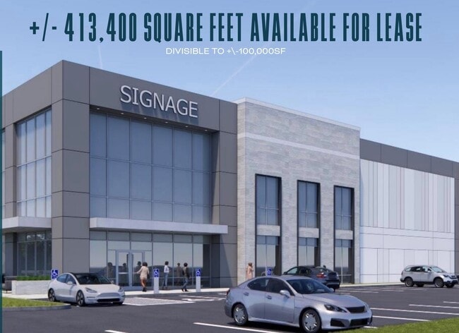
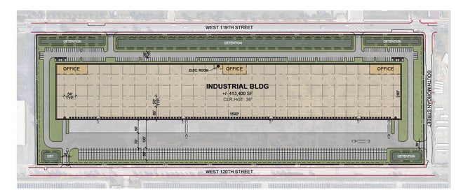
Current Lease Availabilities
NEARBY LISTINGS FOR SALE OR LEASE
Property Detail
11930 S Racine Ave
25-29-101-014-0000
Cook
Vacantlandnec
Illinois
X
1.25 AC
17031C0645J
South Chicago
2023
Chicago
2024
Chicago-Naperville-Elgin, IL-IN-WI
720700
DEMOGRAPHICS near 11930 S Racine Ave
1 Mile
3 Mile
5 Mile
2024 Total Population
19,592
149,035
370,066
2029 Population
19,191
145,998
363,166
Pop Growth 2024-2029
(2.05%)
(2.04%)
(1.86%)
Average Age
41
41
41
2024 Total Households
7,304
56,211
139,995
HH Growth 2024-2029
(2.59%)
(2.51%)
(2.36%)
Median Household Inc
$53,684
$51,256
$54,417
Avg Household Size
2.60
2.60
2.50
2024 Avg HH Vehicles
1.00
1.00
1.00
Median Home Value
$126,959
$161,388
$172,851
Median Year Built
1955
1951
1955
Nearby Places
- Restaurants
- Banks
- Shops
- Fitness
- Groceries
PUBLIC TRANSPORTATION
COMMUTER RAIL
West Pullman Station (Metra Electric Line - Northeast Illinois Regional Commuter Railroad (Metra))
DRIVE
WALK
Distance
West Pullman Station (Metra Electric Line - Northeast Illinois Regional Commuter Railroad (Metra))
2 min
12 min
0.6 mi
Racine Avenue Station (Metra Electric Line - Northeast Illinois Regional Commuter Railroad (Metra))
DRIVE
WALK
Distance
Racine Avenue Station (Metra Electric Line - Northeast Illinois Regional Commuter Railroad (Metra))
5 min
1.4 mi
AIRPORT
Chicago Midway International
DRIVE
WALK
Distance
Chicago Midway International
25 min
13.8 mi
Chicago O'Hare International
DRIVE
WALK
Distance
Chicago O'Hare International
52 min
34.1 mi
Freight Ports
Port Milwaukee
DRIVE
WALK
Distance
Port Milwaukee
130 min
102.3 mi
Nearby Properties
Address
Land Use
TOTAL SIZE
Lot Size
Zoning
Address
Land Use
TOTAL SIZE
Lot Size
Zoning
8 AC
PD 1168
Address
Land Use
TOTAL SIZE
Lot Size
Zoning
0.51 AC
PD 1168
Address
Land Use
TOTAL SIZE
Lot Size
Zoning
1.08 AC
PD 1168
Address
Land Use
TOTAL SIZE
Lot Size
Zoning
11 AC
PD 1168
Address
Land Use
TOTAL SIZE
Lot Size
Zoning
307,335 SF
24.17 AC
PD 770
Address
Land Use
TOTAL SIZE
Lot Size
Zoning
63,930 SF
3.49 AC
PD 181
Address
Land Use
TOTAL SIZE
Lot Size
Zoning
162,000 SF
20.94 AC
PD 1167
Address
Land Use
TOTAL SIZE
Lot Size
Zoning
Address
Land Use
TOTAL SIZE
Lot Size
Zoning
83,005 SF
3.11 AC
Address
Land Use
TOTAL SIZE
Lot Size
Zoning
380,924 SF
19.13 AC
Address
Land Use
TOTAL SIZE
Lot Size
Zoning
129,837 SF
10.44 AC
PD 770
Address
Land Use
TOTAL SIZE
Lot Size
Zoning
Address
Land Use
TOTAL SIZE
Lot Size
Zoning
98,506 SF
7.66 AC
Address
Land Use
TOTAL SIZE
Lot Size
Zoning
1 AC
RS-3
Address
Land Use
TOTAL SIZE
Lot Size
Zoning
105,150 SF
4 AC
Address
Land Use
TOTAL SIZE
Lot Size
Zoning
162,379 SF
10.59 AC
Address
Land Use
TOTAL SIZE
Lot Size
Zoning
8,800 SF
8.83 AC
Address
Land Use
TOTAL SIZE
Lot Size
Zoning
451,400 SF
26.59 AC
M3-3
Address
Land Use
TOTAL SIZE
Lot Size
Zoning
1.71 AC
PD 1168
Address
Land Use
TOTAL SIZE
Lot Size
Zoning
109,213 SF
7.59 AC
Address
Land Use
TOTAL SIZE
Lot Size
Zoning
63,700 SF
0.74 AC
C1-1
Address
Land Use
TOTAL SIZE
Lot Size
Zoning
Address
Land Use
TOTAL SIZE
Lot Size
Zoning
67,348 SF
6.33 AC
PD 131
Address
Land Use
TOTAL SIZE
Lot Size
Zoning
216,386 SF
16.84 AC
PD 42
Address
Land Use
TOTAL SIZE
Lot Size
Zoning
440,257 SF
18.83 AC
M3-3
Address
Land Use
TOTAL SIZE
Lot Size
Zoning
1.38 AC
PD 1168
Address
Land Use
TOTAL SIZE
Lot Size
Zoning
15,600 SF
7.77 AC
PMD 10
Address
Land Use
TOTAL SIZE
Lot Size
Zoning
204,900 SF
26.56 AC
M3-3
Address
Land Use
TOTAL SIZE
Lot Size
Zoning
93,739 SF
1.11 AC
RS-3
Address
Land Use
TOTAL SIZE
Lot Size
Zoning
170,680 SF
15.28 AC
M3-3
The World's #1 Commercial Real Estate Marketplace
Connect with us
© 2025 CoStar Group
The information above has been obtained from sources believed reliable. While we do not doubt its accuracy we have not verified it and make no guarantee, warranty or representation about it. It is your responsibility to independently confirm its accuracy and completeness. Any projections, opinions, assumptions, or estimates used are for example only and do not represent the current or future performance of the property. The value of this transaction to you depends on tax and other factors which should be evaluated by your tax, financial, and legal advisors. You and your advisors should conduct a careful, independent investigation of the property to determine to your satisfaction the suitability of the property for your needs.