Property Record
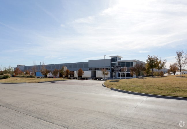
1001 W Bethel Rd, Coppell, TX 75019


Property Detail
1001 W Bethel Rd
18DFW0OS000000000
DALLAS FORT WORTH AIRPORT ACS 123.01 CO-DALLAS DFW0OS0000000 118DFW0OS00
Warehouse
DALLAS
Z402
Texas
B and X Area of moderate flood hazard, usually the area between the limits of the 100-year and 500-year floods.
123.01 AC
0
E DFW Air/Las Colinas
2025
Dallas/Ft Worth
014119
Dallas-Fort Worth-Arlington, TX
2,545,604 SF
NEARBY LISTINGS FOR SALE OR LEASE
DEMOGRAPHICS near 1001 W Bethel Rd
1 mile
3 mile
5 mile
2025 Total Population
13
37,521
178,232
2030 Population
15
39,940
189,250
Pop Growth 2025-2030
+ 15.38%
+ 6.45%
+ 6.18%
Average Age
32
38
38
2025 Total Households
3
15,070
70,497
HH Growth 2025-2030
0.00%
+ 4.69%
+ 5.96%
Median Household Inc
$300,000
$124,332
$115,807
Avg Household Size
4.00
2.50
2.50
2025 Avg HH Vehicles
2.00
2.00
2.00
Median Home Value
$499,999
$606,955
$513,317
Median Year Built
2011
2002
1995
Nearby Places
Map Layers
Map Styles
 Street
 Aerial
Layers
 Traffic
 Biking
Places
Listings with unknown addresses are not visible on the map
- Restaurants
- Banks
- Shops
- Fitness
- Groceries
PUBLIC TRANSPORTATION
AIRPORT
Dallas-Fort Worth International
Drive
Walk
Distance
Dallas-Fort Worth International
12 min
5.7 mi
Dallas Love Field
Drive
Walk
Distance
Dallas Love Field
30 min
17.5 mi
Nearby Properties
Address
Land Use
TOTAL SIZE
Lot Size
Zoning
Address
Land Use
TOTAL SIZE
Lot Size
Zoning
7,321,782 SF
0.01 AC
Z392
Address
Land Use
TOTAL SIZE
Lot Size
Zoning
3,233,905 SF
51.24 AC
Address
Land Use
TOTAL SIZE
Lot Size
Zoning
1,325,709 SF
124.50 AC
Address
Land Use
TOTAL SIZE
Lot Size
Zoning
680,063 SF
36.51 AC
Address
Land Use
TOTAL SIZE
Lot Size
Zoning
444,824 SF
19.08 AC
Address
Land Use
TOTAL SIZE
Lot Size
Zoning
527,463 SF
42.25 AC
Address
Land Use
TOTAL SIZE
Lot Size
Zoning
432,986 SF
10.57 AC
Address
Land Use
TOTAL SIZE
Lot Size
Zoning
500,000 SF
99.10 AC
Address
Land Use
TOTAL SIZE
Lot Size
Zoning
768,494 SF
10.42 AC
Address
Land Use
TOTAL SIZE
Lot Size
Zoning
1,581,742 SF
53.48 AC
Z123
Address
Land Use
TOTAL SIZE
Lot Size
Zoning
190,223 SF
0.03 AC
Z392
Address
Land Use
TOTAL SIZE
Lot Size
Zoning
481,511 SF
34.76 AC
Z172
Address
Land Use
TOTAL SIZE
Lot Size
Zoning
808,352 SF
7.87 AC
Address
Land Use
TOTAL SIZE
Lot Size
Zoning
1,065,080 SF
49.57 AC
Z123
Address
Land Use
TOTAL SIZE
Lot Size
Zoning
397,272 SF
12.35 AC
Address
Land Use
TOTAL SIZE
Lot Size
Zoning
1,076,400 SF
48.83 AC
Z01
Address
Land Use
TOTAL SIZE
Lot Size
Zoning
457,738 SF
28.49 AC
Address
Land Use
TOTAL SIZE
Lot Size
Zoning
313,369 SF
55.25 AC
Address
Land Use
TOTAL SIZE
Lot Size
Zoning
950,000 SF
45.32 AC
Z123
Address
Land Use
TOTAL SIZE
Lot Size
Zoning
389,286 SF
21.86 AC
Address
Land Use
TOTAL SIZE
Lot Size
Zoning
379,940 SF
63.48 AC
Z31
Address
Land Use
TOTAL SIZE
Lot Size
Zoning
284,952 SF
26.18 AC
Address
Land Use
TOTAL SIZE
Lot Size
Zoning
634,939 SF
52.29 AC
Z84
Address
Land Use
TOTAL SIZE
Lot Size
Zoning
184,186 SF
34.74 AC
Z31
Address
Land Use
TOTAL SIZE
Lot Size
Zoning
397,935 SF
10.65 AC
Address
Land Use
TOTAL SIZE
Lot Size
Zoning
581,211 SF
9 AC
Z239
Address
Land Use
TOTAL SIZE
Lot Size
Zoning
329,666 SF
19.76 AC
Address
Land Use
TOTAL SIZE
Lot Size
Zoning
367,000 SF
11.58 AC
Z84
Address
Land Use
TOTAL SIZE
Lot Size
Zoning
295,408 SF
10.33 AC
The World's #1 Commercial Real Estate Marketplace
Connect with us
© 2026 CoStar Group
The information above has been obtained from sources believed reliable. While we do not doubt its accuracy we have not verified it and make no guarantee, warranty or representation about it. It is your responsibility to independently confirm its accuracy and completeness. Any projections, opinions, assumptions, or estimates used are for example only and do not represent the current or future performance of the property. The value of this transaction to you depends on tax and other factors which should be evaluated by your tax, financial, and legal advisors. You and your advisors should conduct a careful, independent investigation of the property to determine to your satisfaction the suitability of the property for your needs.