Property Record
1001 W Saint Bernard Hwy, Chalmette, LA 70043
This Property Is For Sale
NEARBY LISTINGS FOR SALE OR LEASE
Property Detail
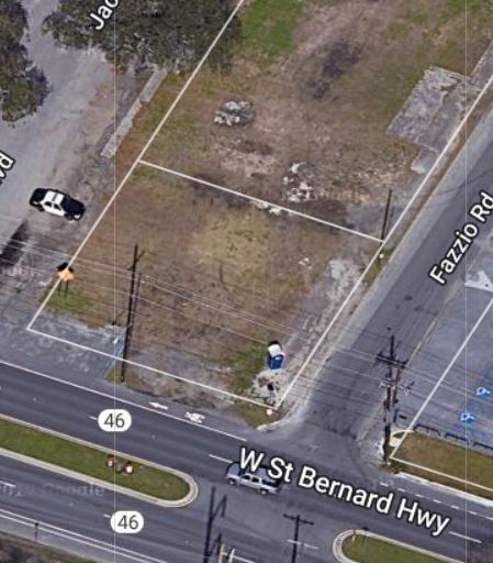
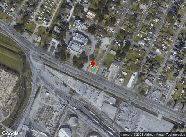
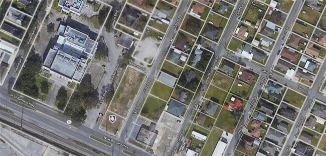
1001 W Saint Bernard Hwy
New Orleans-Metairie, LA
Fazzio Road Subdivision
352300101000
FRT. PTN. SQ.1, FAZZIO SUB. MEAS. 84.37' ON ST. BERN. HWY. X 80.93' ON FAZZIO RD. & 80.93' ON JACKSON BLVD.
Residentialacreage
St Bernard
X
Louisiana
22087C0478D
1000
2024
0.16 AC
2025
Chalmette
030400
New Orleans/Metairie/Kenner
DEMOGRAPHICS near 1001 W Saint Bernard Hwy
1 Mile
3 Mile
5 Mile
2024 Total Population
7,524
57,100
132,811
2029 Population
7,819
56,720
130,222
Pop Growth 2024-2029
+ 3.92%
(0.67%)
(1.95%)
Average Age
37
38
39
2024 Total Households
2,934
21,948
52,399
HH Growth 2024-2029
+ 3.61%
(0.99%)
(2.26%)
Median Household Inc
$52,476
$50,096
$46,897
Avg Household Size
2.50
2.50
2.50
2024 Avg HH Vehicles
2.00
2.00
1.00
Median Home Value
$163,097
$184,076
$190,275
Median Year Built
1970
1972
1971
Nearby Places
Map Layers
Map Styles
 Street
 Aerial
- Restaurants
- Banks
- Shops
- Fitness
- Groceries
PUBLIC TRANSPORTATION
COMMUTER RAIL
New Orleans Union Passenger Terminal (City of New Orleans - Amtrak, Crescent - Amtrak, Sunset Limited - Amtrak)
DRIVE
WALK
Distance
New Orleans Union Passenger Terminal (City of New Orleans - Amtrak, Crescent - Amtrak, Sunset Limited - Amtrak)
18 min
7.9 mi
AIRPORT
Louis Armstrong New Orleans International
DRIVE
WALK
Distance
Louis Armstrong New Orleans International
35 min
21.1 mi
Freight Ports
Plaquemines Port
DRIVE
WALK
Distance
Plaquemines Port
26 min
8.8 mi
Nearby Properties
Address
Land Use
TOTAL SIZE
Lot Size
Zoning
Address
Land Use
TOTAL SIZE
Lot Size
Zoning
Address
Land Use
TOTAL SIZE
Lot Size
Zoning
1.33 AC
HI
Address
Land Use
TOTAL SIZE
Lot Size
Zoning
85,568 SF
23.74 AC
MU-1
Address
Land Use
TOTAL SIZE
Lot Size
Zoning
0.20 AC
Address
Land Use
TOTAL SIZE
Lot Size
Zoning
Address
Land Use
TOTAL SIZE
Lot Size
Zoning
Address
Land Use
TOTAL SIZE
Lot Size
Zoning
140,772 SF
9.01 AC
S-RS
Address
Land Use
TOTAL SIZE
Lot Size
Zoning
Address
Land Use
TOTAL SIZE
Lot Size
Zoning
4.40 AC
Address
Land Use
TOTAL SIZE
Lot Size
Zoning
Address
Land Use
TOTAL SIZE
Lot Size
Zoning
Address
Land Use
TOTAL SIZE
Lot Size
Zoning
Address
Land Use
TOTAL SIZE
Lot Size
Zoning
16.84 AC
EC
Address
Land Use
TOTAL SIZE
Lot Size
Zoning
8.11 AC
EC
Address
Land Use
TOTAL SIZE
Lot Size
Zoning
159,090 SF
23.56 AC
Address
Land Use
TOTAL SIZE
Lot Size
Zoning
2,160 SF
267.42 AC
A1
Address
Land Use
TOTAL SIZE
Lot Size
Zoning
82,611 SF
1.94 AC
HU-RM1
Address
Land Use
TOTAL SIZE
Lot Size
Zoning
Address
Land Use
TOTAL SIZE
Lot Size
Zoning
Address
Land Use
TOTAL SIZE
Lot Size
Zoning
2.06 AC
EC
Address
Land Use
TOTAL SIZE
Lot Size
Zoning
Address
Land Use
TOTAL SIZE
Lot Size
Zoning
53,964 SF
8.06 AC
S-RS
Address
Land Use
TOTAL SIZE
Lot Size
Zoning
Address
Land Use
TOTAL SIZE
Lot Size
Zoning
574,842 SF
53.74 AC
S-RM1
Address
Land Use
TOTAL SIZE
Lot Size
Zoning
0.92 AC
Address
Land Use
TOTAL SIZE
Lot Size
Zoning
Address
Land Use
TOTAL SIZE
Lot Size
Zoning
Address
Land Use
TOTAL SIZE
Lot Size
Zoning
146,262 SF
8.11 AC
EC
Address
Land Use
TOTAL SIZE
Lot Size
Zoning
124,622 SF
6.15 AC
S-RS
Address
Land Use
TOTAL SIZE
Lot Size
Zoning
The World's #1 Commercial Real Estate Marketplace
Connect with us
© 2025 CoStar Group
The information above has been obtained from sources believed reliable. While we do not doubt its accuracy we have not verified it and make no guarantee, warranty or representation about it. It is your responsibility to independently confirm its accuracy and completeness. Any projections, opinions, assumptions, or estimates used are for example only and do not represent the current or future performance of the property. The value of this transaction to you depends on tax and other factors which should be evaluated by your tax, financial, and legal advisors. You and your advisors should conduct a careful, independent investigation of the property to determine to your satisfaction the suitability of the property for your needs.