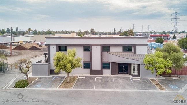
Property Record
10010 Rosedale Hwy, Bakersfield, CA 93312


Current Lease Availabilities
NEARBY LISTINGS FOR SALE OR LEASE
Property Detail
10010 Rosedale Hwy
Bakersfield, CA
Parcel Map 11804
450-052-72-00-9
PARCEL MAP 11804 , LOT 2
Commercialnec
Kern
X
California
06029C1825F
2
2024
2.26 AC
2025
Northwest Bakersfield
003807
Bakersfield
16,800 SF
DEMOGRAPHICS near 10010 Rosedale Hwy
1 Mile
3 Mile
5 Mile
2024 Total Population
10,769
85,533
201,728
2029 Population
10,745
85,323
202,050
Pop Growth 2024-2029
(0.22%)
(0.25%)
+ 0.16%
Average Age
38
38
37
2024 Total Households
3,740
28,812
70,365
HH Growth 2024-2029
(0.32%)
(0.32%)
+ 0.10%
Median Household Inc
$81,528
$103,224
$88,542
Avg Household Size
2.80
2.90
2.80
2024 Avg HH Vehicles
2.00
2.00
2.00
Median Home Value
$288,843
$366,095
$361,344
Median Year Built
1989
1997
1990
Nearby Places
Map Layers
Map Styles
 Street
 Aerial
- Restaurants
- Banks
- Shops
- Fitness
- Groceries
PUBLIC TRANSPORTATION
COMMUTER RAIL
DRIVE
WALK
Distance
15 min
7.3 mi
AIRPORT
Meadows Field
DRIVE
WALK
Distance
Meadows Field
20 min
8.3 mi
Nearby Properties
Address
Land Use
TOTAL SIZE
Lot Size
Zoning
Address
Land Use
TOTAL SIZE
Lot Size
Zoning
60.03 AC
M-3
Address
Land Use
TOTAL SIZE
Lot Size
Zoning
3,788 SF
54.09 AC
M3
Address
Land Use
TOTAL SIZE
Lot Size
Zoning
1,200 SF
5.89 AC
M-1
Address
Land Use
TOTAL SIZE
Lot Size
Zoning
6,702 SF
18.75 AC
C-2
Address
Land Use
TOTAL SIZE
Lot Size
Zoning
1 SF
14.26 AC
R-2 PUD
Address
Land Use
TOTAL SIZE
Lot Size
Zoning
386,282 SF
14.05 AC
Address
Land Use
TOTAL SIZE
Lot Size
Zoning
7,008 SF
46 AC
R1
Address
Land Use
TOTAL SIZE
Lot Size
Zoning
253,532 SF
14.69 AC
Address
Land Use
TOTAL SIZE
Lot Size
Zoning
41,394 SF
14.74 AC
Address
Land Use
TOTAL SIZE
Lot Size
Zoning
134,728 SF
7.56 AC
R3
Address
Land Use
TOTAL SIZE
Lot Size
Zoning
35,250 SF
10.33 AC
C-2 PCD
Address
Land Use
TOTAL SIZE
Lot Size
Zoning
149,197 SF
8.21 AC
PUD
Address
Land Use
TOTAL SIZE
Lot Size
Zoning
15,027 SF
17.72 AC
C-2
Address
Land Use
TOTAL SIZE
Lot Size
Zoning
51,517 SF
8.11 AC
CO
Address
Land Use
TOTAL SIZE
Lot Size
Zoning
138,923 SF
9.97 AC
C-2
Address
Land Use
TOTAL SIZE
Lot Size
Zoning
55,532 SF
4.18 AC
CO
Address
Land Use
TOTAL SIZE
Lot Size
Zoning
1,949 SF
6.43 AC
R-2
Address
Land Use
TOTAL SIZE
Lot Size
Zoning
51,666 SF
6.08 AC
C2
Address
Land Use
TOTAL SIZE
Lot Size
Zoning
92,953 SF
13.59 AC
C2
Address
Land Use
TOTAL SIZE
Lot Size
Zoning
144,414 SF
11.90 AC
PCD
Address
Land Use
TOTAL SIZE
Lot Size
Zoning
55,586 SF
2.49 AC
C-O
Address
Land Use
TOTAL SIZE
Lot Size
Zoning
83,650 SF
2.43 AC
C-2
Address
Land Use
TOTAL SIZE
Lot Size
Zoning
75,569 SF
2.32 AC
C-O
Address
Land Use
TOTAL SIZE
Lot Size
Zoning
72,330 SF
2.59 AC
C-O
Address
Land Use
TOTAL SIZE
Lot Size
Zoning
67,337 SF
2.52 AC
C-O
Address
Land Use
TOTAL SIZE
Lot Size
Zoning
73,055 SF
3.83 AC
PUD
Address
Land Use
TOTAL SIZE
Lot Size
Zoning
215,165 SF
9 AC
M-2
Address
Land Use
TOTAL SIZE
Lot Size
Zoning
16,991 SF
17.46 AC
R1
The World's #1 Commercial Real Estate Marketplace
Connect with us
© 2025 CoStar Group
The information above has been obtained from sources believed reliable. While we do not doubt its accuracy we have not verified it and make no guarantee, warranty or representation about it. It is your responsibility to independently confirm its accuracy and completeness. Any projections, opinions, assumptions, or estimates used are for example only and do not represent the current or future performance of the property. The value of this transaction to you depends on tax and other factors which should be evaluated by your tax, financial, and legal advisors. You and your advisors should conduct a careful, independent investigation of the property to determine to your satisfaction the suitability of the property for your needs.