Property Record
10011 Fm 521 Rd, Rosharon, TX 77583
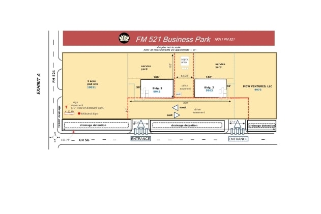


Property Detail
10011 Fm 521 Rd
0068-00-000-0800-907
0068 WM PETTUS, ACRES 3.0914, MH SERIAL # 12528970
Commercialnec
Brazoria
SX
Texas
B and X Area of moderate flood hazard, usually the area between the limits of the 100-year and 500-year floods.
3.09 AC
2024
Southwest Outlier
2025
Houston
674506
Houston-Pasadena-The Woodlands, TX
14,872 SF
NEARBY LISTINGS FOR SALE OR LEASE
DEMOGRAPHICS near 10011 Fm 521 Rd
1 mile
3 mile
5 mile
2025 Total Population
155
19,054
56,473
2030 Population
181
22,324
65,318
Pop Growth 2025-2030
+ 16.77%
+ 17.16%
+ 15.66%
Average Age
33
34
35
2025 Total Households
48
5,811
16,707
HH Growth 2025-2030
+ 18.75%
+ 17.78%
+ 16.33%
Median Household Inc
$92,045
$89,777
$120,370
Avg Household Size
3.20
3.20
3.30
2025 Avg HH Vehicles
2.00
2.00
2.00
Median Home Value
$308,333
$309,174
$393,817
Median Year Built
2010
2010
2010
Nearby Places
Map Layers
Map Styles
 Street
 Aerial
Layers
 Traffic
 Biking
Places
Listings with unknown addresses are not visible on the map
- Restaurants
- Banks
- Shops
- Fitness
- Groceries
PUBLIC TRANSPORTATION
AIRPORT
William P Hobby
Drive
Walk
Distance
William P Hobby
39 min
24.1 mi
Freight Ports
Port of Houston
Drive
Walk
Distance
Port of Houston
44 min
30.9 mi
Nearby Properties
Address
Land Use
TOTAL SIZE
Lot Size
Zoning
Address
Land Use
TOTAL SIZE
Lot Size
Zoning
Address
Land Use
TOTAL SIZE
Lot Size
Zoning
228,566 SF
31.85 AC
Address
Land Use
TOTAL SIZE
Lot Size
Zoning
123,079 SF
14.99 AC
Address
Land Use
TOTAL SIZE
Lot Size
Zoning
Address
Land Use
TOTAL SIZE
Lot Size
Zoning
2,727.82 AC
0002
Address
Land Use
TOTAL SIZE
Lot Size
Zoning
65,403 SF
14.65 AC
Address
Land Use
TOTAL SIZE
Lot Size
Zoning
4,400.55 AC
0009
Address
Land Use
TOTAL SIZE
Lot Size
Zoning
127,500 SF
7.60 AC
Address
Land Use
TOTAL SIZE
Lot Size
Zoning
70,000 SF
64.91 AC
Address
Land Use
TOTAL SIZE
Lot Size
Zoning
2,000 SF
24.85 AC
Address
Land Use
TOTAL SIZE
Lot Size
Zoning
28,633 SF
9.36 AC
Address
Land Use
TOTAL SIZE
Lot Size
Zoning
14,968 SF
1.81 AC
Address
Land Use
TOTAL SIZE
Lot Size
Zoning
47,500 SF
Address
Land Use
TOTAL SIZE
Lot Size
Zoning
16,298 SF
2.87 AC
Address
Land Use
TOTAL SIZE
Lot Size
Zoning
672 SF
11.35 AC
Address
Land Use
TOTAL SIZE
Lot Size
Zoning
274.73 AC
Address
Land Use
TOTAL SIZE
Lot Size
Zoning
17,250 SF
2.39 AC
Address
Land Use
TOTAL SIZE
Lot Size
Zoning
91.43 AC
SQ
Address
Land Use
TOTAL SIZE
Lot Size
Zoning
7,298 SF
7.97 AC
Address
Land Use
TOTAL SIZE
Lot Size
Zoning
Address
Land Use
TOTAL SIZE
Lot Size
Zoning
1.86 AC
Address
Land Use
TOTAL SIZE
Lot Size
Zoning
665.06 AC
ZT
Address
Land Use
TOTAL SIZE
Lot Size
Zoning
41,540 SF
5.71 AC
Address
Land Use
TOTAL SIZE
Lot Size
Zoning
17,700 SF
2.59 AC
Address
Land Use
TOTAL SIZE
Lot Size
Zoning
1.56 AC
Address
Land Use
TOTAL SIZE
Lot Size
Zoning
7,795 SF
4.30 AC
Address
Land Use
TOTAL SIZE
Lot Size
Zoning
11,341 SF
4.45 AC
AQS
Address
Land Use
TOTAL SIZE
Lot Size
Zoning
10,080 SF
4.06 AC
Address
Land Use
TOTAL SIZE
Lot Size
Zoning
7,256 SF
1.91 AC
Address
Land Use
TOTAL SIZE
Lot Size
Zoning
41,670 SF
8.60 AC
0007
The World's #1 Commercial Real Estate Marketplace
Connect with us
© 2026 CoStar Group
The information above has been obtained from sources believed reliable. While we do not doubt its accuracy we have not verified it and make no guarantee, warranty or representation about it. It is your responsibility to independently confirm its accuracy and completeness. Any projections, opinions, assumptions, or estimates used are for example only and do not represent the current or future performance of the property. The value of this transaction to you depends on tax and other factors which should be evaluated by your tax, financial, and legal advisors. You and your advisors should conduct a careful, independent investigation of the property to determine to your satisfaction the suitability of the property for your needs.