Property Record
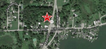
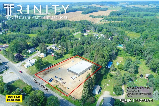
10011 Route 16, Delevan, NY 14042


Property Detail
10011 Route 16
045800 21.060-1-20.2
CATTARAUGUS
Storebuilding
New York
01 - NOT Z
20.002
2025
3.40 AC
2025
New York West Area
960200
Other Market Areas
9,100 SF
Olean, NY
NEARBY LISTINGS FOR SALE OR LEASE
-
-
View all Delevan listings for sale on LoopNet.com
DEMOGRAPHICS near 10011 Route 16
1 mile
3 mile
5 mile
2025 Total Population
936
2,350
4,722
2030 Population
931
2,338
4,675
Pop Growth 2025-2030
(0.53%)
(0.51%)
(1.00%)
Average Age
44
44
43
2025 Total Households
372
935
1,931
HH Growth 2025-2030
(0.54%)
(0.64%)
(1.09%)
Median Household Inc
$53,750
$55,583
$50,952
Avg Household Size
2.40
2.40
2.40
2025 Avg HH Vehicles
2.00
2.00
2.00
Median Home Value
$102,747
$110,480
$116,522
Median Year Built
1975
1976
1977
Nearby Places
Map Layers
Map Styles
 Street
 Aerial
Layers
 Traffic
 Biking
Places
Listings with unknown addresses are not visible on the map
- Restaurants
- Banks
- Shops
- Fitness
- Groceries
SALE & LEASE HISTORY
LISTING DATE
SALE/LEASE

Aug 31, 2017
For Sale
Aug 03, 2017
For Sale
Nearby Properties
Address
Land Use
TOTAL SIZE
Lot Size
Zoning
Address
Land Use
TOTAL SIZE
Lot Size
Zoning
2.44 AC
01 - NOT Z
Address
Land Use
TOTAL SIZE
Lot Size
Zoning
69,750 SF
28.50 AC
01 - NOT Z
Address
Land Use
TOTAL SIZE
Lot Size
Zoning
4,000 SF
63.82 AC
01 - NOT Z
Address
Land Use
TOTAL SIZE
Lot Size
Zoning
2,802 SF
22.30 AC
01 - NOT Z
Address
Land Use
TOTAL SIZE
Lot Size
Zoning
1,680 SF
43.65 AC
01 - NOT Z
Address
Land Use
TOTAL SIZE
Lot Size
Zoning
10,368 SF
8.50 AC
01 - NOT Z
Address
Land Use
TOTAL SIZE
Lot Size
Zoning
14,640 SF
1.40 AC
01 - NOT Z
Address
Land Use
TOTAL SIZE
Lot Size
Zoning
12.35 AC
01 - NOT Z
Address
Land Use
TOTAL SIZE
Lot Size
Zoning
2,000 SF
0.30 AC
01 - NOT Z
Address
Land Use
TOTAL SIZE
Lot Size
Zoning
28.55 AC
Address
Land Use
TOTAL SIZE
Lot Size
Zoning
2,744 SF
1.75 AC
01 - NOT Z
Address
Land Use
TOTAL SIZE
Lot Size
Zoning
120.75 AC
01 - NOT Z
Address
Land Use
TOTAL SIZE
Lot Size
Zoning
200.97 AC
01 - NOT Z
Address
Land Use
TOTAL SIZE
Lot Size
Zoning
660 SF
0.26 AC
01 - NOT Z
Address
Land Use
TOTAL SIZE
Lot Size
Zoning
780 SF
0.03 AC
01 - NOT Z
Address
Land Use
TOTAL SIZE
Lot Size
Zoning
6,608 SF
1.25 AC
01 - NOT Z
Address
Land Use
TOTAL SIZE
Lot Size
Zoning
1,456 SF
99.40 AC
01 - NOT Z
Address
Land Use
TOTAL SIZE
Lot Size
Zoning
2,400 SF
97.35 AC
01 - NOT Z
Address
Land Use
TOTAL SIZE
Lot Size
Zoning
1,452 SF
0.13 AC
01 - NOT Z
Address
Land Use
TOTAL SIZE
Lot Size
Zoning
13,800 SF
3.50 AC
01 - NOT Z
Address
Land Use
TOTAL SIZE
Lot Size
Zoning
136.10 AC
01 - NOT Z
Address
Land Use
TOTAL SIZE
Lot Size
Zoning
4,032 SF
1.95 AC
01 - NOT Z
Address
Land Use
TOTAL SIZE
Lot Size
Zoning
1,876 SF
157.55 AC
01 - NOT Z
Address
Land Use
TOTAL SIZE
Lot Size
Zoning
143.90 AC
01 - NOT Z
Address
Land Use
TOTAL SIZE
Lot Size
Zoning
960 SF
1.16 AC
01 - NOT Z
Address
Land Use
TOTAL SIZE
Lot Size
Zoning
99.93 AC
01 - NOT Z
Address
Land Use
TOTAL SIZE
Lot Size
Zoning
2,006 SF
1.15 AC
01 - NOT Z
Address
Land Use
TOTAL SIZE
Lot Size
Zoning
170.63 AC
01 - NOT Z
Address
Land Use
TOTAL SIZE
Lot Size
Zoning
864 SF
3.20 AC
01 - NOT Z
The World's #1 Commercial Real Estate Marketplace
Connect with us
© 2026 CoStar Group
The information above has been obtained from sources believed reliable. While we do not doubt its accuracy we have not verified it and make no guarantee, warranty or representation about it. It is your responsibility to independently confirm its accuracy and completeness. Any projections, opinions, assumptions, or estimates used are for example only and do not represent the current or future performance of the property. The value of this transaction to you depends on tax and other factors which should be evaluated by your tax, financial, and legal advisors. You and your advisors should conduct a careful, independent investigation of the property to determine to your satisfaction the suitability of the property for your needs.