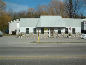
Property Record
10017 E Cherry Bend Rd, Traverse City, MI 49684


Save to a Folder
{{folder.Name}}
{{folder.ListingIds.length}} Properties
{{folder.ListingIds.length}} Property
Create a New Folder
Property Detail
10017 E Cherry Bend Rd
004-028-133-10
S 126 FT OF N 206 FT OF NW 1/4 OF SW 1/4 LYING E OF C/L CO RD 633 SEC 28 T28N R11W.
Commercialnec
Leelanau
B and X Area of moderate flood hazard, usually the area between the limits of the 100-year and 500-year floods.
Michigan
2025
0.69 AC
2026
Michigan Northwest Area
970601
Other Market Areas
1,140 SF
Traverse City, MI
NEARBY LISTINGS FOR SALE OR LEASE
DEMOGRAPHICS near 10017 E Cherry Bend Rd
1 mile
3 mile
5 mile
2025 Total Population
1,320
9,473
33,424
2030 Population
1,305
9,476
33,254
Pop Growth 2025-2030
(1.14%)
+ 0.03%
(0.51%)
Average Age
47
46
45
2025 Total Households
580
4,260
15,132
HH Growth 2025-2030
(1.38%)
+ 0.12%
(0.52%)
Median Household Inc
$96,645
$99,974
$82,587
Avg Household Size
2.20
2.10
2.10
2025 Avg HH Vehicles
2.00
2.00
2.00
Median Home Value
$419,802
$466,607
$404,024
Median Year Built
1985
1971
1979
Nearby Places
Map Layers
Map Styles
 Street
 Aerial
Layers
 Traffic
 Biking
Places
Listings with unknown addresses are not visible on the map
- Restaurants
- Banks
- Shops
- Fitness
- Groceries
PUBLIC TRANSPORTATION
AIRPORT
Cherry Capital
Drive
Walk
Distance
Cherry Capital
19 min
7.2 mi
Freight Ports
Port Milwaukee
Drive
Walk
Distance
Port Milwaukee
470 min
407.0 mi
SALE & LEASE HISTORY
LISTING DATE
SALE/LEASE

Aug 06, 2024
For Sale
Nearby Properties
Address
Land Use
TOTAL SIZE
Lot Size
Zoning
Address
Land Use
TOTAL SIZE
Lot Size
Zoning
3,682 SF
9.21 AC
Address
Land Use
TOTAL SIZE
Lot Size
Zoning
100,935 SF
35.95 AC
Address
Land Use
TOTAL SIZE
Lot Size
Zoning
Address
Land Use
TOTAL SIZE
Lot Size
Zoning
54,254 SF
4.83 AC
Address
Land Use
TOTAL SIZE
Lot Size
Zoning
40,791 SF
1.53 AC
Address
Land Use
TOTAL SIZE
Lot Size
Zoning
78,739 SF
0.84 AC
Address
Land Use
TOTAL SIZE
Lot Size
Zoning
103,000 SF
4.77 AC
Address
Land Use
TOTAL SIZE
Lot Size
Zoning
131,040 SF
22.23 AC
Address
Land Use
TOTAL SIZE
Lot Size
Zoning
61,480 SF
0.49 AC
Address
Land Use
TOTAL SIZE
Lot Size
Zoning
123,544 SF
3.93 AC
Address
Land Use
TOTAL SIZE
Lot Size
Zoning
13.13 AC
Address
Land Use
TOTAL SIZE
Lot Size
Zoning
960 SF
2.24 AC
Address
Land Use
TOTAL SIZE
Lot Size
Zoning
57,780 SF
1.77 AC
Address
Land Use
TOTAL SIZE
Lot Size
Zoning
71,389 SF
0.65 AC
Address
Land Use
TOTAL SIZE
Lot Size
Zoning
77,000 SF
1.71 AC
Address
Land Use
TOTAL SIZE
Lot Size
Zoning
99,848 SF
0.99 AC
Address
Land Use
TOTAL SIZE
Lot Size
Zoning
39,988 SF
0.88 AC
Address
Land Use
TOTAL SIZE
Lot Size
Zoning
33,184 SF
0.76 AC
Address
Land Use
TOTAL SIZE
Lot Size
Zoning
71,400 SF
3.69 AC
Address
Land Use
TOTAL SIZE
Lot Size
Zoning
Address
Land Use
TOTAL SIZE
Lot Size
Zoning
42,598 SF
6.14 AC
Address
Land Use
TOTAL SIZE
Lot Size
Zoning
Address
Land Use
TOTAL SIZE
Lot Size
Zoning
70,134 SF
1.37 AC
Address
Land Use
TOTAL SIZE
Lot Size
Zoning
Address
Land Use
TOTAL SIZE
Lot Size
Zoning
4,524 SF
1.13 AC
Address
Land Use
TOTAL SIZE
Lot Size
Zoning
Address
Land Use
TOTAL SIZE
Lot Size
Zoning
186,482 SF
1.43 AC
Address
Land Use
TOTAL SIZE
Lot Size
Zoning
40,958 SF
0.31 AC
Address
Land Use
TOTAL SIZE
Lot Size
Zoning
Address
Land Use
TOTAL SIZE
Lot Size
Zoning
The World's #1 Commercial Real Estate Marketplace
Connect with us
© 2026 CoStar Group
The information above has been obtained from sources believed reliable. While we do not doubt its accuracy we have not verified it and make no guarantee, warranty or representation about it. It is your responsibility to independently confirm its accuracy and completeness. Any projections, opinions, assumptions, or estimates used are for example only and do not represent the current or future performance of the property. The value of this transaction to you depends on tax and other factors which should be evaluated by your tax, financial, and legal advisors. You and your advisors should conduct a careful, independent investigation of the property to determine to your satisfaction the suitability of the property for your needs.