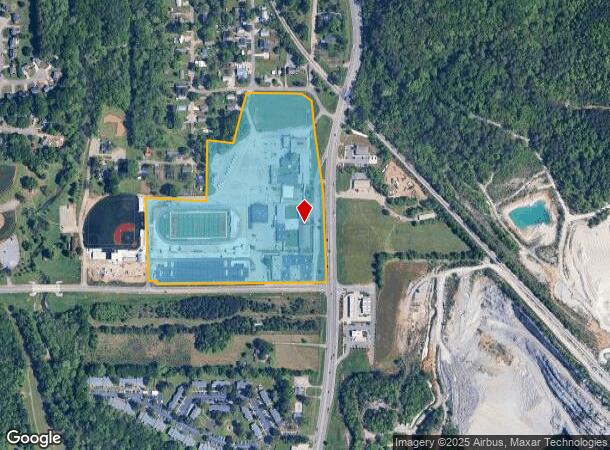
Property Record
10019 Highway 119, Alabaster, AL 35007
NEARBY LISTINGS FOR SALE OR LEASE
Property Detail
10019 Highway 119
231112004001000
Old Thompson High School Sub
Publicschool
BEG INTER N ROW CO HWY 264 & W ROW HWY 119 N ALG ROW TO S ROW CENTER AVE W ALG ROW 420(S) SWLY345(S) WLY168.6 SLY374.4 W748
AE
Shelby
01117C0377E
Alabama
2024
24.97 AC
2024
I-65 Corr/S Shelby County
030306
Birmingham
77,365 SF
Birmingham-Hoover, AL
DEMOGRAPHICS near 10019 Highway 119
1 Mile
3 Mile
5 Mile
2024 Total Population
4,863
32,935
61,416
2029 Population
5,260
35,664
66,529
Pop Growth 2024-2029
+ 8.16%
+ 8.29%
+ 8.33%
Average Age
38
39
39
2024 Total Households
1,742
11,636
22,139
HH Growth 2024-2029
+ 8.38%
+ 8.46%
+ 8.49%
Median Household Inc
$68,960
$82,868
$85,832
Avg Household Size
2.80
2.80
2.70
2024 Avg HH Vehicles
2.00
2.00
2.00
Median Home Value
$173,372
$227,855
$237,437
Median Year Built
1989
1994
1995
Nearby Places
Map Layers
Map Styles
 Street
 Aerial
- Restaurants
- Banks
- Shops
- Fitness
- Groceries
PUBLIC TRANSPORTATION
AIRPORT
Birmingham-Shuttlesworth International
DRIVE
WALK
Distance
Birmingham-Shuttlesworth International
39 min
29.4 mi
Nearby Properties
Address
Land Use
TOTAL SIZE
Lot Size
Zoning
Address
Land Use
TOTAL SIZE
Lot Size
Zoning
228,107 SF
12 AC
Address
Land Use
TOTAL SIZE
Lot Size
Zoning
2,100 SF
6.50 AC
Address
Land Use
TOTAL SIZE
Lot Size
Zoning
3,872 SF
20.35 AC
Address
Land Use
TOTAL SIZE
Lot Size
Zoning
9,444 SF
21.79 AC
Address
Land Use
TOTAL SIZE
Lot Size
Zoning
1,763 SF
21.99 AC
Address
Land Use
TOTAL SIZE
Lot Size
Zoning
61,602 SF
145.23 AC
Address
Land Use
TOTAL SIZE
Lot Size
Zoning
11,192 SF
26.78 AC
Address
Land Use
TOTAL SIZE
Lot Size
Zoning
226,790 SF
40 AC
Address
Land Use
TOTAL SIZE
Lot Size
Zoning
219,975 SF
14.90 AC
Address
Land Use
TOTAL SIZE
Lot Size
Zoning
161,753 SF
25 AC
Address
Land Use
TOTAL SIZE
Lot Size
Zoning
220,000 SF
21.76 AC
Address
Land Use
TOTAL SIZE
Lot Size
Zoning
62,398 SF
11.51 AC
Address
Land Use
TOTAL SIZE
Lot Size
Zoning
84,355 SF
15.65 AC
Address
Land Use
TOTAL SIZE
Lot Size
Zoning
126,897 SF
9.43 AC
Address
Land Use
TOTAL SIZE
Lot Size
Zoning
1,388 SF
17.81 AC
Address
Land Use
TOTAL SIZE
Lot Size
Zoning
8,416 SF
16.12 AC
Address
Land Use
TOTAL SIZE
Lot Size
Zoning
6,864 SF
6.11 AC
Address
Land Use
TOTAL SIZE
Lot Size
Zoning
30,158 SF
8.35 AC
Address
Land Use
TOTAL SIZE
Lot Size
Zoning
137,068 SF
9.08 AC
Address
Land Use
TOTAL SIZE
Lot Size
Zoning
120,043 SF
30 AC
Address
Land Use
TOTAL SIZE
Lot Size
Zoning
154,440 SF
12.03 AC
Address
Land Use
TOTAL SIZE
Lot Size
Zoning
54,297 SF
41 AC
Address
Land Use
TOTAL SIZE
Lot Size
Zoning
121,500 SF
13.80 AC
Address
Land Use
TOTAL SIZE
Lot Size
Zoning
43,903 SF
10.21 AC
Address
Land Use
TOTAL SIZE
Lot Size
Zoning
Address
Land Use
TOTAL SIZE
Lot Size
Zoning
5,000 SF
43 AC
Address
Land Use
TOTAL SIZE
Lot Size
Zoning
51,264 SF
6.98 AC
Address
Land Use
TOTAL SIZE
Lot Size
Zoning
41,120 SF
10.24 AC
The World's #1 Commercial Real Estate Marketplace
Connect with us
© 2026 CoStar Group
The information above has been obtained from sources believed reliable. While we do not doubt its accuracy we have not verified it and make no guarantee, warranty or representation about it. It is your responsibility to independently confirm its accuracy and completeness. Any projections, opinions, assumptions, or estimates used are for example only and do not represent the current or future performance of the property. The value of this transaction to you depends on tax and other factors which should be evaluated by your tax, financial, and legal advisors. You and your advisors should conduct a careful, independent investigation of the property to determine to your satisfaction the suitability of the property for your needs.