Property Record
1002 Cameron Dr, Durand, IL 61024
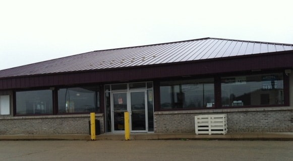

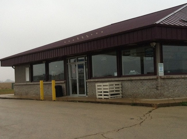
Property Detail
1002 Cameron Dr
Rockford, IL
OTTER CREEK SUB NO 2 CORRECTED PLAT PTSE1/4 SEC 15-28-10 W 120 FT LT 41 & ALL LOT 40
05-15-402-001
Winnebago
Commercialnec
Illinois
B and X Area of moderate flood hazard, usually the area between the limits of the 100-year and 500-year floods.
41,40
2024
1.31 AC
2024
I-39 Corr/Winnebago Cnty
004100
Chicago
NEARBY LISTINGS FOR SALE OR LEASE
-
-
View all Durand listings for sale on LoopNet.com
DEMOGRAPHICS near 1002 Cameron Dr
1 mile
3 mile
5 mile
2025 Total Population
1,272
1,715
6,306
2030 Population
1,256
1,708
6,393
Pop Growth 2025-2030
(1.26%)
(0.41%)
+ 1.38%
Average Age
42
43
46
2025 Total Households
512
691
2,614
HH Growth 2025-2030
(1.37%)
(0.43%)
+ 1.42%
Median Household Inc
$72,187
$73,531
$91,214
Avg Household Size
2.40
2.40
2.40
2025 Avg HH Vehicles
2.00
2.00
2.00
Median Home Value
$157,846
$165,173
$212,460
Median Year Built
1973
1974
1983
Nearby Places
Map Layers
Map Styles
 Street
 Aerial
Transit
 Traffic
 Biking
Places
Listings with unknown addresses are not visible on the map
- Restaurants
- Banks
- Shops
- Fitness
- Groceries
PUBLIC TRANSPORTATION
AIRPORT
Chicago/Rockford International
Drive
Walk
Distance
Chicago/Rockford International
42 min
26.6 mi
Nearby Properties
Address
Land Use
TOTAL SIZE
Lot Size
Zoning
Address
Land Use
TOTAL SIZE
Lot Size
Zoning
5.73 AC
Address
Land Use
TOTAL SIZE
Lot Size
Zoning
0.15 AC
Address
Land Use
TOTAL SIZE
Lot Size
Zoning
1.06 AC
Address
Land Use
TOTAL SIZE
Lot Size
Zoning
3.19 AC
Address
Land Use
TOTAL SIZE
Lot Size
Zoning
11.18 AC
AG
Address
Land Use
TOTAL SIZE
Lot Size
Zoning
Address
Land Use
TOTAL SIZE
Lot Size
Zoning
40 AC
AG
Address
Land Use
TOTAL SIZE
Lot Size
Zoning
249.89 AC
AG
Address
Land Use
TOTAL SIZE
Lot Size
Zoning
217.09 AC
AG
Address
Land Use
TOTAL SIZE
Lot Size
Zoning
17.45 AC
AG
Address
Land Use
TOTAL SIZE
Lot Size
Zoning
1.52 AC
Address
Land Use
TOTAL SIZE
Lot Size
Zoning
6.52 AC
CC
Address
Land Use
TOTAL SIZE
Lot Size
Zoning
40 AC
AG
Address
Land Use
TOTAL SIZE
Lot Size
Zoning
19.94 AC
AG
Address
Land Use
TOTAL SIZE
Lot Size
Zoning
20 AC
AG
Address
Land Use
TOTAL SIZE
Lot Size
Zoning
Address
Land Use
TOTAL SIZE
Lot Size
Zoning
78.65 AC
AG
Address
Land Use
TOTAL SIZE
Lot Size
Zoning
157.90 AC
AG
Address
Land Use
TOTAL SIZE
Lot Size
Zoning
5.32 AC
Address
Land Use
TOTAL SIZE
Lot Size
Zoning
1.66 AC
Address
Land Use
TOTAL SIZE
Lot Size
Zoning
56.83 AC
AG
Address
Land Use
TOTAL SIZE
Lot Size
Zoning
109.52 AC
AG
Address
Land Use
TOTAL SIZE
Lot Size
Zoning
Address
Land Use
TOTAL SIZE
Lot Size
Zoning
80.85 AC
AG
Address
Land Use
TOTAL SIZE
Lot Size
Zoning
40 AC
AG
Address
Land Use
TOTAL SIZE
Lot Size
Zoning
75.16 AC
AG
Address
Land Use
TOTAL SIZE
Lot Size
Zoning
40 AC
AG
Address
Land Use
TOTAL SIZE
Lot Size
Zoning
102.40 AC
AG
Address
Land Use
TOTAL SIZE
Lot Size
Zoning
10 AC
AG
The World's #1 Commercial Real Estate Marketplace
Connect with us
© 2026 CoStar Group
The information above has been obtained from sources believed reliable. While we do not doubt its accuracy we have not verified it and make no guarantee, warranty or representation about it. It is your responsibility to independently confirm its accuracy and completeness. Any projections, opinions, assumptions, or estimates used are for example only and do not represent the current or future performance of the property. The value of this transaction to you depends on tax and other factors which should be evaluated by your tax, financial, and legal advisors. You and your advisors should conduct a careful, independent investigation of the property to determine to your satisfaction the suitability of the property for your needs.