Property Record
1002 Gateway Dr, Chaska, MN 55318


Save to a Folder
{{folder.Name}}
{{folder.ListingIds.length}} Properties
{{folder.ListingIds.length}} Property
Create a New Folder
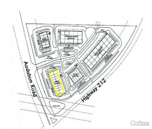
Property Detail
1002 Gateway Dr
30.0790020
CARVER
Stripcommercialcenter
Minnesota
B and X Area of moderate flood hazard, usually the area between the limits of the 100-year and 500-year floods.
2
2026
1.82 AC
2026
Eden Prairie
090801
Minneapolis/St Paul
14,770 SF
Minneapolis-St. Paul-Bloomington, MN-WI
NEARBY LISTINGS FOR SALE OR LEASE
DEMOGRAPHICS near 1002 Gateway Dr
1 mile
3 mile
5 mile
2025 Total Population
5,374
39,034
97,860
2030 Population
5,514
40,486
101,501
Pop Growth 2025-2030
+ 2.61%
+ 3.72%
+ 3.72%
Average Age
39
39
39
2025 Total Households
1,933
14,574
35,502
HH Growth 2025-2030
+ 2.90%
+ 3.84%
+ 3.86%
Median Household Inc
$99,218
$106,328
$118,690
Avg Household Size
2.70
2.60
2.70
2025 Avg HH Vehicles
2.00
2.00
2.00
Median Home Value
$338,106
$367,226
$427,542
Median Year Built
1991
1993
1997
Nearby Places
Map Layers
Map Styles
 Street
 Aerial
Layers
 Traffic
 Biking
Places
Listings with unknown addresses are not visible on the map
- Restaurants
- Banks
- Shops
- Fitness
- Groceries
PUBLIC TRANSPORTATION
AIRPORT
Minneapolis-St Paul International/Wold-Chamberlain
Drive
Walk
Distance
Minneapolis-St Paul International/Wold-Chamberlain
32 min
21.8 mi
Freight Ports
Port Milwaukee
Drive
Walk
Distance
Port Milwaukee
400 min
359.0 mi
SALE & LEASE HISTORY
LISTING DATE
SALE/LEASE

Sep 24, 2016
For Lease
Sep 24, 2016
For Lease
Jul 13, 2017
For Sale
Nearby Properties
Address
Land Use
TOTAL SIZE
Lot Size
Zoning
Address
Land Use
TOTAL SIZE
Lot Size
Zoning
209,623 SF
72.81 AC
Address
Land Use
TOTAL SIZE
Lot Size
Zoning
60,208 SF
47.61 AC
Address
Land Use
TOTAL SIZE
Lot Size
Zoning
20,086 SF
12.99 AC
Address
Land Use
TOTAL SIZE
Lot Size
Zoning
27.70 AC
Address
Land Use
TOTAL SIZE
Lot Size
Zoning
44,611 SF
9.75 AC
Address
Land Use
TOTAL SIZE
Lot Size
Zoning
20,586 SF
19.34 AC
Address
Land Use
TOTAL SIZE
Lot Size
Zoning
600,000 SF
31.21 AC
Address
Land Use
TOTAL SIZE
Lot Size
Zoning
Address
Land Use
TOTAL SIZE
Lot Size
Zoning
57,769 SF
62.10 AC
Address
Land Use
TOTAL SIZE
Lot Size
Zoning
51,272 SF
2.11 AC
Address
Land Use
TOTAL SIZE
Lot Size
Zoning
198,754 SF
27.50 AC
Address
Land Use
TOTAL SIZE
Lot Size
Zoning
52,280 SF
12.15 AC
Address
Land Use
TOTAL SIZE
Lot Size
Zoning
164,809 SF
7.28 AC
Address
Land Use
TOTAL SIZE
Lot Size
Zoning
254,602 SF
18.19 AC
Address
Land Use
TOTAL SIZE
Lot Size
Zoning
73,937 SF
23.89 AC
Address
Land Use
TOTAL SIZE
Lot Size
Zoning
26.05 AC
Address
Land Use
TOTAL SIZE
Lot Size
Zoning
1.80 AC
Address
Land Use
TOTAL SIZE
Lot Size
Zoning
Address
Land Use
TOTAL SIZE
Lot Size
Zoning
191,395 SF
5.16 AC
Address
Land Use
TOTAL SIZE
Lot Size
Zoning
1.96 AC
Address
Land Use
TOTAL SIZE
Lot Size
Zoning
65,038 SF
6.72 AC
Address
Land Use
TOTAL SIZE
Lot Size
Zoning
50,536 SF
8.45 AC
Address
Land Use
TOTAL SIZE
Lot Size
Zoning
2.93 AC
Address
Land Use
TOTAL SIZE
Lot Size
Zoning
138,865 SF
12.55 AC
Address
Land Use
TOTAL SIZE
Lot Size
Zoning
131,154 SF
21.76 AC
Address
Land Use
TOTAL SIZE
Lot Size
Zoning
25,092 SF
2.07 AC
Address
Land Use
TOTAL SIZE
Lot Size
Zoning
4.74 AC
Address
Land Use
TOTAL SIZE
Lot Size
Zoning
10,038 SF
12.21 AC
Address
Land Use
TOTAL SIZE
Lot Size
Zoning
16.92 AC
The World's #1 Commercial Real Estate Marketplace
Connect with us
© 2026 CoStar Group
The information above has been obtained from sources believed reliable. While we do not doubt its accuracy we have not verified it and make no guarantee, warranty or representation about it. It is your responsibility to independently confirm its accuracy and completeness. Any projections, opinions, assumptions, or estimates used are for example only and do not represent the current or future performance of the property. The value of this transaction to you depends on tax and other factors which should be evaluated by your tax, financial, and legal advisors. You and your advisors should conduct a careful, independent investigation of the property to determine to your satisfaction the suitability of the property for your needs.