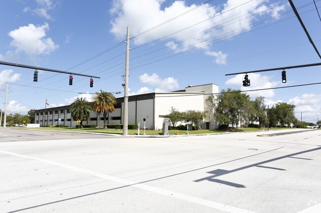
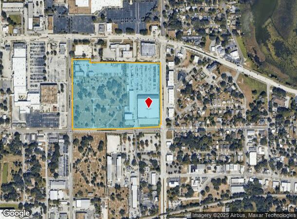
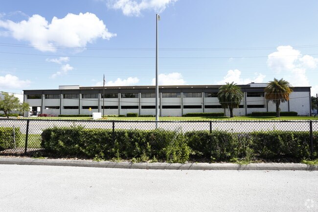
Property Record
1002 Parker Rd, Lakeland, FL 33811

NEARBY LISTINGS FOR SALE OR LEASE
Property Detail
1002 Parker Rd
24-28-18-000000-011010
Dogwood Homes
Municipalproperty
E1/4 OF NE1/4 S OF SR 600 LESS BEG NW COR OF NE1/4 OF NE1/4 RUN S O DEG 22E 67.85 FT N 89 DEG 27E 453.41 FT FOR BEG RUN N 89 DEG 27E 308.47 FT TO PC OF CURVE OF 2814.94 RADIUS CURVING TO RIGHT OR SELY ALONG CURVE AND R/W LINE 191.58 FT S 0 DEG 1840E
X
Polk
12105C0315G
Florida
0
27.09 AC
2025
Polk County
011913
Tampa/St Petersburg
118,806 SF
Lakeland-Winter Haven, FL
DEMOGRAPHICS near 1002 Parker Rd
1 Mile
3 Mile
5 Mile
2024 Total Population
7,117
71,775
151,559
2029 Population
8,561
85,340
180,914
Pop Growth 2024-2029
+ 20.29%
+ 18.90%
+ 19.37%
Average Age
38
38
40
2024 Total Households
3,068
26,919
60,320
HH Growth 2024-2029
+ 20.60%
+ 19.41%
+ 19.63%
Median Household Inc
$33,794
$40,964
$50,416
Avg Household Size
2.10
2.30
2.30
2024 Avg HH Vehicles
1.00
1.00
2.00
Median Home Value
$161,568
$147,668
$165,746
Median Year Built
1972
1972
1980
Nearby Places
Map Layers
Map Styles
 Street
 Aerial
- Restaurants
- Banks
- Shops
- Fitness
- Groceries
PUBLIC TRANSPORTATION
COMMUTER RAIL
DRIVE
WALK
Distance
3 min
1.2 mi
Freight Ports
Port of Tampa Bay
DRIVE
WALK
Distance
Port of Tampa Bay
47 min
35.2 mi
Nearby Properties
Address
Land Use
TOTAL SIZE
Lot Size
Zoning
Address
Land Use
TOTAL SIZE
Lot Size
Zoning
2,325,080 SF
27.05 AC
PUD
Address
Land Use
TOTAL SIZE
Lot Size
Zoning
414,112 SF
13.60 AC
MF22
Address
Land Use
TOTAL SIZE
Lot Size
Zoning
363,693 SF
22.54 AC
R2
Address
Land Use
TOTAL SIZE
Lot Size
Zoning
333,455 SF
11.90 AC
Address
Land Use
TOTAL SIZE
Lot Size
Zoning
263,185 SF
32.20 AC
C6
Address
Land Use
TOTAL SIZE
Lot Size
Zoning
417,661 SF
39.48 AC
Address
Land Use
TOTAL SIZE
Lot Size
Zoning
24,871 SF
54.24 AC
RB1
Address
Land Use
TOTAL SIZE
Lot Size
Zoning
295,706 SF
1.19 AC
Address
Land Use
TOTAL SIZE
Lot Size
Zoning
394,631 SF
32.27 AC
XX
Address
Land Use
TOTAL SIZE
Lot Size
Zoning
277,272 SF
19.35 AC
RA4
Address
Land Use
TOTAL SIZE
Lot Size
Zoning
282,596 SF
27.51 AC
RA3
Address
Land Use
TOTAL SIZE
Lot Size
Zoning
84,824 SF
163.73 AC
I2
Address
Land Use
TOTAL SIZE
Lot Size
Zoning
258,946 SF
11.73 AC
O3
Address
Land Use
TOTAL SIZE
Lot Size
Zoning
165,743 SF
17.11 AC
PUD
Address
Land Use
TOTAL SIZE
Lot Size
Zoning
682,828 SF
36.01 AC
Address
Land Use
TOTAL SIZE
Lot Size
Zoning
155,735 SF
24.24 AC
XX
Address
Land Use
TOTAL SIZE
Lot Size
Zoning
342,987 SF
16.81 AC
Address
Land Use
TOTAL SIZE
Lot Size
Zoning
103,446 SF
2.12 AC
RB1
Address
Land Use
TOTAL SIZE
Lot Size
Zoning
135,189 SF
2.57 AC
RB1
Address
Land Use
TOTAL SIZE
Lot Size
Zoning
96,412 SF
11.03 AC
I1
Address
Land Use
TOTAL SIZE
Lot Size
Zoning
101,501 SF
16.54 AC
Address
Land Use
TOTAL SIZE
Lot Size
Zoning
180,802 SF
76.35 AC
Address
Land Use
TOTAL SIZE
Lot Size
Zoning
286,120 SF
2.49 AC
C6
Address
Land Use
TOTAL SIZE
Lot Size
Zoning
210,000 SF
12.91 AC
Address
Land Use
TOTAL SIZE
Lot Size
Zoning
175,230 SF
7.23 AC
MF22
Address
Land Use
TOTAL SIZE
Lot Size
Zoning
292,124 SF
29.70 AC
PUD
Address
Land Use
TOTAL SIZE
Lot Size
Zoning
210,000 SF
13.28 AC
Address
Land Use
TOTAL SIZE
Lot Size
Zoning
87,975 SF
5.45 AC
O1
Address
Land Use
TOTAL SIZE
Lot Size
Zoning
109,883 SF
12.40 AC
C4
Address
Land Use
TOTAL SIZE
Lot Size
Zoning
171,629 SF
14.91 AC
RA4
The World's #1 Commercial Real Estate Marketplace
Connect with us
© 2026 CoStar Group
The information above has been obtained from sources believed reliable. While we do not doubt its accuracy we have not verified it and make no guarantee, warranty or representation about it. It is your responsibility to independently confirm its accuracy and completeness. Any projections, opinions, assumptions, or estimates used are for example only and do not represent the current or future performance of the property. The value of this transaction to you depends on tax and other factors which should be evaluated by your tax, financial, and legal advisors. You and your advisors should conduct a careful, independent investigation of the property to determine to your satisfaction the suitability of the property for your needs.