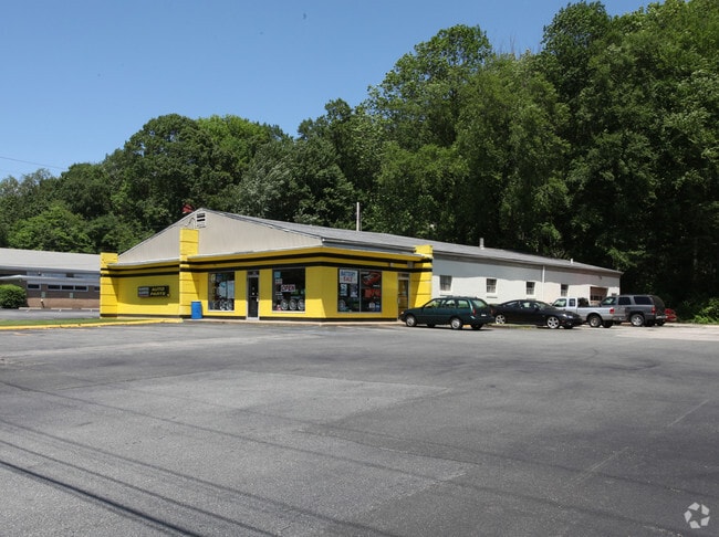
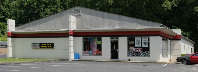
Property Record
1002 Route 12, Groton, CT 06340

Property Detail
1002 Route 12
Autorepair
Southeastern Ct
CN
Connecticut
B and X Area of moderate flood hazard, usually the area between the limits of the 100-year and 500-year floods.
2.54 AC
2025
New London
2025
Hartford
870200
Norwich-New London-Willimantic, CT
6,120 SF
GROT-001780-001443-003098
NEARBY LISTINGS FOR SALE OR LEASE
DEMOGRAPHICS near 1002 Route 12
1 mile
3 mile
5 mile
2025 Total Population
5,063
39,173
80,710
2030 Population
5,134
39,454
81,338
Pop Growth 2025-2030
+ 1.40%
+ 0.72%
+ 0.78%
Average Age
33
38
40
2025 Total Households
1,299
14,961
32,392
HH Growth 2025-2030
+ 2.31%
+ 0.88%
+ 0.88%
Median Household Inc
$83,346
$74,847
$77,327
Avg Household Size
2.60
2.30
2.20
2025 Avg HH Vehicles
2.00
2.00
2.00
Median Home Value
$267,088
$278,198
$287,647
Median Year Built
1986
1969
1968
Nearby Places
Map Layers
Map Styles
 Street
 Aerial
Layers
 Traffic
 Biking
Places
Listings with unknown addresses are not visible on the map
- Restaurants
- Banks
- Shops
- Fitness
- Groceries
PUBLIC TRANSPORTATION
COMMUTER RAIL
New London (Shore Line East - Shore Line East)
Drive
Walk
Distance
New London (Shore Line East - Shore Line East)
9 min
5.0 mi
Drive
Walk
Distance
16 min
8.6 mi
Freight Ports
Port of New Haven
Drive
Walk
Distance
Port of New Haven
63 min
48.7 mi
Nearby Properties
Address
Land Use
TOTAL SIZE
Lot Size
Zoning
Address
Land Use
TOTAL SIZE
Lot Size
Zoning
8,712 SF
RU-20
Address
Land Use
TOTAL SIZE
Lot Size
Zoning
45,582 SF
39.40 AC
WCI-1
Address
Land Use
TOTAL SIZE
Lot Size
Zoning
49.32 AC
R-3
Address
Land Use
TOTAL SIZE
Lot Size
Zoning
42,688 SF
19.22 AC
RM
Address
Land Use
TOTAL SIZE
Lot Size
Zoning
251.73 AC
RM40
Address
Land Use
TOTAL SIZE
Lot Size
Zoning
287.66 AC
RU-20
Address
Land Use
TOTAL SIZE
Lot Size
Zoning
11,880 SF
35.66 AC
RM
Address
Land Use
TOTAL SIZE
Lot Size
Zoning
54.80 AC
INST
Address
Land Use
TOTAL SIZE
Lot Size
Zoning
13.68 AC
CR
Address
Land Use
TOTAL SIZE
Lot Size
Zoning
21.84 AC
C-2
Address
Land Use
TOTAL SIZE
Lot Size
Zoning
60.63 AC
RU-20
Address
Land Use
TOTAL SIZE
Lot Size
Zoning
73,446 SF
69.87 AC
R-12
Address
Land Use
TOTAL SIZE
Lot Size
Zoning
104,052 SF
27.36 AC
RM
Address
Land Use
TOTAL SIZE
Lot Size
Zoning
55,766 SF
1.33 AC
R-4
Address
Land Use
TOTAL SIZE
Lot Size
Zoning
66.87 AC
RU-20
Address
Land Use
TOTAL SIZE
Lot Size
Zoning
69,658 SF
16.31 AC
VR-10
Address
Land Use
TOTAL SIZE
Lot Size
Zoning
125,275 SF
10 AC
RM
Address
Land Use
TOTAL SIZE
Lot Size
Zoning
79,535 SF
3.03 AC
R-2
Address
Land Use
TOTAL SIZE
Lot Size
Zoning
204,329 SF
17.92 AC
CR
Address
Land Use
TOTAL SIZE
Lot Size
Zoning
135,113 SF
2.51 AC
LI-O
Address
Land Use
TOTAL SIZE
Lot Size
Zoning
9.41 AC
R-4
Address
Land Use
TOTAL SIZE
Lot Size
Zoning
5.65 AC
R-2
Address
Land Use
TOTAL SIZE
Lot Size
Zoning
33.50 AC
R-12
Address
Land Use
TOTAL SIZE
Lot Size
Zoning
52,065 SF
12.40 AC
CN
Address
Land Use
TOTAL SIZE
Lot Size
Zoning
12.55 AC
C-2
Address
Land Use
TOTAL SIZE
Lot Size
Zoning
65,512 SF
123.23 AC
RU-20
Address
Land Use
TOTAL SIZE
Lot Size
Zoning
18.76 AC
INST
Address
Land Use
TOTAL SIZE
Lot Size
Zoning
7,112 SF
R-12
Address
Land Use
TOTAL SIZE
Lot Size
Zoning
0.54 AC
CBD-1
Address
Land Use
TOTAL SIZE
Lot Size
Zoning
60,592 SF
12.95 AC
MTC
The World's #1 Commercial Real Estate Marketplace
Connect with us
© 2026 CoStar Group
The information above has been obtained from sources believed reliable. While we do not doubt its accuracy we have not verified it and make no guarantee, warranty or representation about it. It is your responsibility to independently confirm its accuracy and completeness. Any projections, opinions, assumptions, or estimates used are for example only and do not represent the current or future performance of the property. The value of this transaction to you depends on tax and other factors which should be evaluated by your tax, financial, and legal advisors. You and your advisors should conduct a careful, independent investigation of the property to determine to your satisfaction the suitability of the property for your needs.