Property Record
1002 Sharview Cir, Charlotte, NC 28217
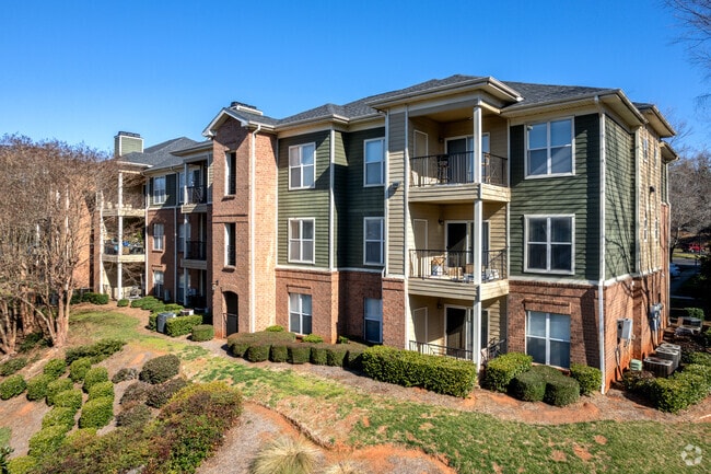

Property Detail
1002 Sharview Cir
167-072-01
TR3 U/M
Multifamilydwelling
MECKLENBURG
R12MFCD
North Carolina
B and X Area of moderate flood hazard, usually the area between the limits of the 100-year and 500-year floods.
1
2024
24.47 AC
2025
Yorkmount
003810
Charlotte
307,493 SF
Charlotte-Concord-Gastonia, NC-SC
NEARBY LISTINGS FOR SALE OR LEASE
DEMOGRAPHICS near 1002 Sharview Cir
1 mile
3 mile
5 mile
2025 Total Population
8,860
76,688
205,055
2030 Population
9,559
83,837
223,873
Pop Growth 2025-2030
+ 7.89%
+ 9.32%
+ 9.18%
Average Age
35
36
37
2025 Total Households
3,461
33,367
92,578
HH Growth 2025-2030
+ 7.92%
+ 9.37%
+ 9.26%
Median Household Inc
$66,377
$74,520
$90,377
Avg Household Size
2.40
2.20
2.20
2025 Avg HH Vehicles
2.00
2.00
2.00
Median Home Value
$269,469
$415,797
$547,554
Median Year Built
1992
1992
1995
Nearby Places
Map Layers
Map Styles
 Street
 Aerial
Layers
 Traffic
 Biking
Places
Listings with unknown addresses are not visible on the map
- Restaurants
- Banks
- Shops
- Fitness
- Groceries
PUBLIC TRANSPORTATION
COMMUTER RAIL
Charlotte Amtrak Station (Carolinian - Amtrak, Crescent - Amtrak, Piedmont - Amtrak)
Drive
Walk
Distance
Charlotte Amtrak Station (Carolinian - Amtrak, Crescent - Amtrak, Piedmont - Amtrak)
13 min
7.6 mi
AIRPORT
Charlotte/Douglas International
Drive
Walk
Distance
Charlotte/Douglas International
12 min
5.0 mi
Concord-Padgett Regional
Drive
Walk
Distance
Concord-Padgett Regional
32 min
22.3 mi
Freight Ports
North Charleston Terminal
Drive
Walk
Distance
North Charleston Terminal
220 min
194.3 mi
Nearby Properties
Address
Land Use
TOTAL SIZE
Lot Size
Zoning
Address
Land Use
TOTAL SIZE
Lot Size
Zoning
505,747 SF
3.87 AC
Address
Land Use
TOTAL SIZE
Lot Size
Zoning
546,111 SF
4.85 AC
MUDDCD
Address
Land Use
TOTAL SIZE
Lot Size
Zoning
399,398 SF
35.02 AC
Address
Land Use
TOTAL SIZE
Lot Size
Zoning
434,803 SF
4.58 AC
I2
Address
Land Use
TOTAL SIZE
Lot Size
Zoning
393,779 SF
26.71 AC
R17MF
Address
Land Use
TOTAL SIZE
Lot Size
Zoning
554,176 SF
3.88 AC
I-2
Address
Land Use
TOTAL SIZE
Lot Size
Zoning
473,582 SF
3.41 AC
TOD-TR
Address
Land Use
TOTAL SIZE
Lot Size
Zoning
356,838 SF
27.63 AC
B1
Address
Land Use
TOTAL SIZE
Lot Size
Zoning
24.40 AC
UR-2(CD)
Address
Land Use
TOTAL SIZE
Lot Size
Zoning
23,502 SF
3.31 AC
TOD-CC
Address
Land Use
TOTAL SIZE
Lot Size
Zoning
395,382 SF
9.84 AC
MUDDO
Address
Land Use
TOTAL SIZE
Lot Size
Zoning
408,632 SF
50 AC
R12MFCD
Address
Land Use
TOTAL SIZE
Lot Size
Zoning
443,379 SF
2.62 AC
TOD-CC
Address
Land Use
TOTAL SIZE
Lot Size
Zoning
371,416 SF
30.90 AC
BPCD
Address
Land Use
TOTAL SIZE
Lot Size
Zoning
424,279 SF
4.20 AC
R43MF
Address
Land Use
TOTAL SIZE
Lot Size
Zoning
298,298 SF
16.60 AC
R17MFCD
Address
Land Use
TOTAL SIZE
Lot Size
Zoning
182,742 SF
324.42 AC
I2
Address
Land Use
TOTAL SIZE
Lot Size
Zoning
283,082 SF
3.35 AC
I-2(TS-O)
Address
Land Use
TOTAL SIZE
Lot Size
Zoning
339,546 SF
7.52 AC
Address
Land Use
TOTAL SIZE
Lot Size
Zoning
661,612 SF
32.38 AC
I1CD
Address
Land Use
TOTAL SIZE
Lot Size
Zoning
604,827 SF
41.01 AC
O1CD
Address
Land Use
TOTAL SIZE
Lot Size
Zoning
245,979 SF
7.60 AC
Address
Land Use
TOTAL SIZE
Lot Size
Zoning
302,196 SF
6.60 AC
I2
Address
Land Use
TOTAL SIZE
Lot Size
Zoning
268,872 SF
48.51 AC
I1CD
Address
Land Use
TOTAL SIZE
Lot Size
Zoning
375,064 SF
10.87 AC
R-22MF
Address
Land Use
TOTAL SIZE
Lot Size
Zoning
289,148 SF
17.12 AC
Address
Land Use
TOTAL SIZE
Lot Size
Zoning
39,670 SF
4.05 AC
I2
Address
Land Use
TOTAL SIZE
Lot Size
Zoning
290,581 SF
8.48 AC
Address
Land Use
TOTAL SIZE
Lot Size
Zoning
272,801 SF
12.90 AC
The World's #1 Commercial Real Estate Marketplace
Connect with us
© 2026 CoStar Group
The information above has been obtained from sources believed reliable. While we do not doubt its accuracy we have not verified it and make no guarantee, warranty or representation about it. It is your responsibility to independently confirm its accuracy and completeness. Any projections, opinions, assumptions, or estimates used are for example only and do not represent the current or future performance of the property. The value of this transaction to you depends on tax and other factors which should be evaluated by your tax, financial, and legal advisors. You and your advisors should conduct a careful, independent investigation of the property to determine to your satisfaction the suitability of the property for your needs.