Property Record
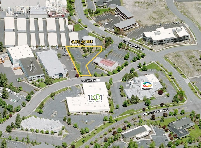
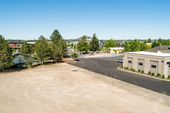
1002 Sw Emkay Dr, Bend, OR 97702

Property Detail
1002 Sw Emkay Dr
274666
PP2016-29 LOT PARCEL 2
Industrialgeneral
Deschutes
MU
Oregon
B and X Area of moderate flood hazard, usually the area between the limits of the 100-year and 500-year floods.
0.53 AC
2025
Deschutes County
2025
Portland
001402
Bend, OR
1,440 SF
NEARBY LISTINGS FOR SALE OR LEASE
DEMOGRAPHICS near 1002 Sw Emkay Dr
1 mile
3 mile
5 mile
2025 Total Population
9,403
70,444
109,839
2030 Population
9,847
72,374
112,492
Pop Growth 2025-2030
+ 4.72%
+ 2.74%
+ 2.42%
Average Age
42
41
41
2025 Total Households
4,056
29,307
44,736
HH Growth 2025-2030
+ 4.68%
+ 2.69%
+ 2.39%
Median Household Inc
$108,500
$101,907
$102,556
Avg Household Size
2.20
2.30
2.40
2025 Avg HH Vehicles
2.00
2.00
2.00
Median Home Value
$859,977
$787,538
$759,149
Median Year Built
1994
2000
2000
Nearby Places
Map Layers
Map Styles
 Street
 Aerial
Transit
 Traffic
 Biking
Places
Listings with unknown addresses are not visible on the map
- Restaurants
- Banks
- Shops
- Fitness
- Groceries
PUBLIC TRANSPORTATION
AIRPORT
Roberts Field
Drive
Walk
Distance
Roberts Field
29 min
18.4 mi
SALE & LEASE HISTORY
LISTING DATE
SALE/LEASE

Jul 01, 2019
For Sale
Aug 29, 2017
For Sale
Aug 09, 2021
For Sale
Nearby Properties
Address
Land Use
TOTAL SIZE
Lot Size
Zoning
Address
Land Use
TOTAL SIZE
Lot Size
Zoning
3.74 AC
MR
Address
Land Use
TOTAL SIZE
Lot Size
Zoning
25,574 SF
3.74 AC
MR
Address
Land Use
TOTAL SIZE
Lot Size
Zoning
27,863 SF
4.23 AC
MU
Address
Land Use
TOTAL SIZE
Lot Size
Zoning
318,598 SF
9.77 AC
RS
Address
Land Use
TOTAL SIZE
Lot Size
Zoning
166,371 SF
2.52 AC
MU
Address
Land Use
TOTAL SIZE
Lot Size
Zoning
199,892 SF
19.16 AC
CG
Address
Land Use
TOTAL SIZE
Lot Size
Zoning
1.04 AC
CB
Address
Land Use
TOTAL SIZE
Lot Size
Zoning
201,575 SF
1.04 AC
CB
Address
Land Use
TOTAL SIZE
Lot Size
Zoning
165,048 SF
4.68 AC
RM
Address
Land Use
TOTAL SIZE
Lot Size
Zoning
1,248 SF
5.04 AC
RM
Address
Land Use
TOTAL SIZE
Lot Size
Zoning
129,449 SF
2.91 AC
MR
Address
Land Use
TOTAL SIZE
Lot Size
Zoning
229,286 SF
17.96 AC
CG
Address
Land Use
TOTAL SIZE
Lot Size
Zoning
70,294 SF
17.96 AC
CG
Address
Land Use
TOTAL SIZE
Lot Size
Zoning
24.36 AC
Address
Land Use
TOTAL SIZE
Lot Size
Zoning
24.36 AC
IG
Address
Land Use
TOTAL SIZE
Lot Size
Zoning
24.36 AC
IG
Address
Land Use
TOTAL SIZE
Lot Size
Zoning
46,317 SF
5.67 AC
RM
Address
Land Use
TOTAL SIZE
Lot Size
Zoning
170,218 SF
13.27 AC
RS
Address
Land Use
TOTAL SIZE
Lot Size
Zoning
49,923 SF
18.42 AC
PF
Address
Land Use
TOTAL SIZE
Lot Size
Zoning
172,121 SF
3.92 AC
RH
Address
Land Use
TOTAL SIZE
Lot Size
Zoning
132,020 SF
12.11 AC
CG
Address
Land Use
TOTAL SIZE
Lot Size
Zoning
21.41 AC
MU
Address
Land Use
TOTAL SIZE
Lot Size
Zoning
2.17 AC
Address
Land Use
TOTAL SIZE
Lot Size
Zoning
88,619 SF
2.17 AC
ME
Address
Land Use
TOTAL SIZE
Lot Size
Zoning
7,920 SF
8.62 AC
RH
Address
Land Use
TOTAL SIZE
Lot Size
Zoning
105,069 SF
4.97 AC
RS
Address
Land Use
TOTAL SIZE
Lot Size
Zoning
164,959 SF
9.30 AC
CG
Address
Land Use
TOTAL SIZE
Lot Size
Zoning
164,959 SF
9.30 AC
CG
Address
Land Use
TOTAL SIZE
Lot Size
Zoning
7.73 AC
MR
The World's #1 Commercial Real Estate Marketplace
Connect with us
© 2026 CoStar Group
The information above has been obtained from sources believed reliable. While we do not doubt its accuracy we have not verified it and make no guarantee, warranty or representation about it. It is your responsibility to independently confirm its accuracy and completeness. Any projections, opinions, assumptions, or estimates used are for example only and do not represent the current or future performance of the property. The value of this transaction to you depends on tax and other factors which should be evaluated by your tax, financial, and legal advisors. You and your advisors should conduct a careful, independent investigation of the property to determine to your satisfaction the suitability of the property for your needs.