Property Record
1002 W Hanna Ave, Indianapolis, IN 46217


NEARBY LISTINGS FOR SALE OR LEASE
Property Detail
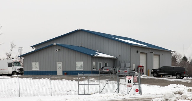
1002 W Hanna Ave
49-11-27-108-006.000-500
4 C0 The Land Referreqzto Herein Below I
Warehouse
PT SE1/4 SE1/4 S27 T15 R3 BEG 30 W OF SE COR P.O.B. W659.7 N1271.35 E512.25 SERLY 275.5 S1036.09 TO BEG 18.82AC ( 17.8AC TAX)
AE
Marion
18097C0233F
Indiana
2023
18.82 AC
2024
Bluff Road
380103
Indianapolis
159,500 SF
Indianapolis-Carmel-Anderson, IN
DEMOGRAPHICS near 1002 W Hanna Ave
1 Mile
3 Mile
5 Mile
2024 Total Population
1,171
50,800
201,400
2029 Population
1,159
50,489
200,515
Pop Growth 2024-2029
(1.02%)
(0.61%)
(0.44%)
Average Age
38
36
36
2024 Total Households
421
19,200
80,733
HH Growth 2024-2029
(1.19%)
(0.71%)
(0.34%)
Median Household Inc
$58,090
$54,995
$59,149
Avg Household Size
2.40
2.50
2.40
2024 Avg HH Vehicles
2.00
2.00
2.00
Median Home Value
$204,286
$152,694
$165,371
Median Year Built
1965
1958
1965
Nearby Places
Map Layers
Map Styles
 Street
 Aerial
- Restaurants
- Banks
- Shops
- Fitness
- Groceries
PUBLIC TRANSPORTATION
COMMUTER RAIL
DRIVE
WALK
Distance
10 min
5.3 mi
AIRPORT
Indianapolis International
DRIVE
WALK
Distance
Indianapolis International
25 min
13.0 mi
Nearby Properties
Address
Land Use
TOTAL SIZE
Lot Size
Zoning
Address
Land Use
TOTAL SIZE
Lot Size
Zoning
111,238 SF
0.06 AC
ZO01
Address
Land Use
TOTAL SIZE
Lot Size
Zoning
67,783 SF
44.97 AC
ZO01
Address
Land Use
TOTAL SIZE
Lot Size
Zoning
5,470 SF
35.46 AC
Address
Land Use
TOTAL SIZE
Lot Size
Zoning
405,888 SF
19.56 AC
ZO01
Address
Land Use
TOTAL SIZE
Lot Size
Zoning
51,801 SF
0.06 AC
ZO01
Address
Land Use
TOTAL SIZE
Lot Size
Zoning
80,348 SF
2.95 AC
ZO01
Address
Land Use
TOTAL SIZE
Lot Size
Zoning
1,812 SF
11.08 AC
ZO01
Address
Land Use
TOTAL SIZE
Lot Size
Zoning
3,818 SF
15.24 AC
Address
Land Use
TOTAL SIZE
Lot Size
Zoning
51,196 SF
50.61 AC
ZO01
Address
Land Use
TOTAL SIZE
Lot Size
Zoning
61,832 SF
0.06 AC
ZO01
Address
Land Use
TOTAL SIZE
Lot Size
Zoning
3,003 SF
3.52 AC
ZO01
Address
Land Use
TOTAL SIZE
Lot Size
Zoning
5,665 SF
25.25 AC
ZO01
Address
Land Use
TOTAL SIZE
Lot Size
Zoning
39,618 SF
8.17 AC
ZO01
Address
Land Use
TOTAL SIZE
Lot Size
Zoning
595,354 SF
193.41 AC
ZO01
Address
Land Use
TOTAL SIZE
Lot Size
Zoning
378,039 SF
0.06 AC
ZO01
Address
Land Use
TOTAL SIZE
Lot Size
Zoning
537,085 SF
111.99 AC
ZO01
Address
Land Use
TOTAL SIZE
Lot Size
Zoning
438,419 SF
17.26 AC
ZO01
Address
Land Use
TOTAL SIZE
Lot Size
Zoning
1,932 SF
19.63 AC
ZO01
Address
Land Use
TOTAL SIZE
Lot Size
Zoning
113,213 SF
0.06 AC
ZO01
Address
Land Use
TOTAL SIZE
Lot Size
Zoning
75,012 SF
0.06 AC
ZO01
Address
Land Use
TOTAL SIZE
Lot Size
Zoning
290,347 SF
30.40 AC
ZO01
Address
Land Use
TOTAL SIZE
Lot Size
Zoning
2,928 SF
17.76 AC
Address
Land Use
TOTAL SIZE
Lot Size
Zoning
119,063 SF
0.06 AC
ZO01
Address
Land Use
TOTAL SIZE
Lot Size
Zoning
882,000 SF
194.98 AC
ZO01
Address
Land Use
TOTAL SIZE
Lot Size
Zoning
257,337 SF
0.06 AC
ZO01
Address
Land Use
TOTAL SIZE
Lot Size
Zoning
9,160 SF
2.54 AC
ZO01
Address
Land Use
TOTAL SIZE
Lot Size
Zoning
220,708 SF
26.81 AC
ZO01
Address
Land Use
TOTAL SIZE
Lot Size
Zoning
38,598 SF
2.83 AC
ZO01
Address
Land Use
TOTAL SIZE
Lot Size
Zoning
112,178 SF
23.51 AC
ZO01
Address
Land Use
TOTAL SIZE
Lot Size
Zoning
3,552 SF
9.70 AC
ZO01
The World's #1 Commercial Real Estate Marketplace
Connect with us
© 2026 CoStar Group
The information above has been obtained from sources believed reliable. While we do not doubt its accuracy we have not verified it and make no guarantee, warranty or representation about it. It is your responsibility to independently confirm its accuracy and completeness. Any projections, opinions, assumptions, or estimates used are for example only and do not represent the current or future performance of the property. The value of this transaction to you depends on tax and other factors which should be evaluated by your tax, financial, and legal advisors. You and your advisors should conduct a careful, independent investigation of the property to determine to your satisfaction the suitability of the property for your needs.