Property Record
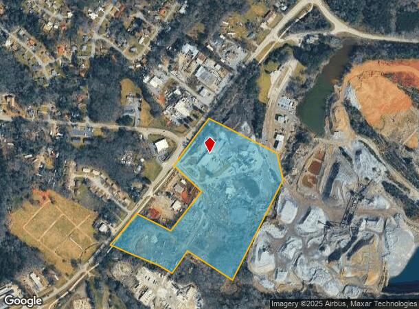
1002 Winterville Rd, Athens, GA 30605
NEARBY LISTINGS FOR SALE OR LEASE
Property Detail
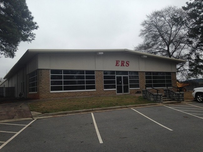
1002 Winterville Rd
231-010
Com-St-020->15-25
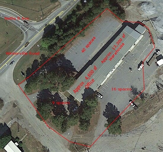
Officebuilding
DEEDED ACS: 28.920
X
Clarke
13059C0027E
Georgia
2025
26.81 AC
2025
Eastside Athens
140500
Other Market Areas
18,000 SF
Athens-Clarke County, GA
DEMOGRAPHICS near 1002 Winterville Rd
1 Mile
3 Mile
5 Mile
2024 Total Population
4,398
60,296
101,141
2029 Population
4,434
60,407
101,405
Pop Growth 2024-2029
+ 0.82%
+ 0.18%
+ 0.26%
Average Age
37
31
34
2024 Total Households
1,700
22,890
39,810
HH Growth 2024-2029
+ 0.88%
+ 0.17%
+ 0.25%
Median Household Inc
$37,134
$42,172
$48,161
Avg Household Size
2.50
2.20
2.20
2024 Avg HH Vehicles
1.00
2.00
2.00
Median Home Value
$149,042
$218,082
$239,764
Median Year Built
1973
1985
1984
Nearby Places
Map Layers
Map Styles
 Street
 Aerial
- Restaurants
- Banks
- Shops
- Fitness
- Groceries
SALE & LEASE HISTORY
LISTING DATE
SALE/LEASE

Sep 25, 2016
For Lease
Nearby Properties
Address
Land Use
TOTAL SIZE
Lot Size
Zoning
Address
Land Use
TOTAL SIZE
Lot Size
Zoning
33.61 AC
G
Address
Land Use
TOTAL SIZE
Lot Size
Zoning
81,812 SF
6.23 AC
C-D (RIV)
Address
Land Use
TOTAL SIZE
Lot Size
Zoning
21.57 AC
G
Address
Land Use
TOTAL SIZE
Lot Size
Zoning
49.33 AC
G
Address
Land Use
TOTAL SIZE
Lot Size
Zoning
35 AC
G
Address
Land Use
TOTAL SIZE
Lot Size
Zoning
17.90 AC
G
Address
Land Use
TOTAL SIZE
Lot Size
Zoning
24.70 AC
G
Address
Land Use
TOTAL SIZE
Lot Size
Zoning
47.56 AC
G
Address
Land Use
TOTAL SIZE
Lot Size
Zoning
163,904 SF
3.75 AC
C-D
Address
Land Use
TOTAL SIZE
Lot Size
Zoning
2,094.97 AC
G
Address
Land Use
TOTAL SIZE
Lot Size
Zoning
10,240 SF
6.47 AC
G
Address
Land Use
TOTAL SIZE
Lot Size
Zoning
300,000 SF
122.56 AC
G
Address
Land Use
TOTAL SIZE
Lot Size
Zoning
104,964 SF
40.38 AC
RM-2
Address
Land Use
TOTAL SIZE
Lot Size
Zoning
16.60 AC
G
Address
Land Use
TOTAL SIZE
Lot Size
Zoning
21.64 AC
G
Address
Land Use
TOTAL SIZE
Lot Size
Zoning
225,000 SF
98.91 AC
G
Address
Land Use
TOTAL SIZE
Lot Size
Zoning
56.20 AC
G
Address
Land Use
TOTAL SIZE
Lot Size
Zoning
122,400 SF
12.51 AC
G
Address
Land Use
TOTAL SIZE
Lot Size
Zoning
21.04 AC
G
Address
Land Use
TOTAL SIZE
Lot Size
Zoning
5.49 AC
G
Address
Land Use
TOTAL SIZE
Lot Size
Zoning
8.38 AC
G
Address
Land Use
TOTAL SIZE
Lot Size
Zoning
213,612 SF
3.07 AC
C-D
Address
Land Use
TOTAL SIZE
Lot Size
Zoning
184,293 SF
1.84 AC
C-D
Address
Land Use
TOTAL SIZE
Lot Size
Zoning
226,339 SF
2.32 AC
C-D (RIV)
Address
Land Use
TOTAL SIZE
Lot Size
Zoning
36.88 AC
G
Address
Land Use
TOTAL SIZE
Lot Size
Zoning
17.23 AC
G
Address
Land Use
TOTAL SIZE
Lot Size
Zoning
6.15 AC
G
Address
Land Use
TOTAL SIZE
Lot Size
Zoning
81,973 SF
4.97 AC
G
Address
Land Use
TOTAL SIZE
Lot Size
Zoning
5,501 SF
1.47 AC
C-D
Address
Land Use
TOTAL SIZE
Lot Size
Zoning
3.16 AC
E-I
The World's #1 Commercial Real Estate Marketplace
Connect with us
© 2025 CoStar Group
The information above has been obtained from sources believed reliable. While we do not doubt its accuracy we have not verified it and make no guarantee, warranty or representation about it. It is your responsibility to independently confirm its accuracy and completeness. Any projections, opinions, assumptions, or estimates used are for example only and do not represent the current or future performance of the property. The value of this transaction to you depends on tax and other factors which should be evaluated by your tax, financial, and legal advisors. You and your advisors should conduct a careful, independent investigation of the property to determine to your satisfaction the suitability of the property for your needs.