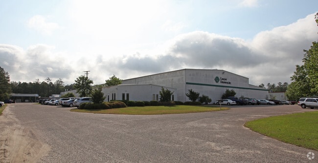
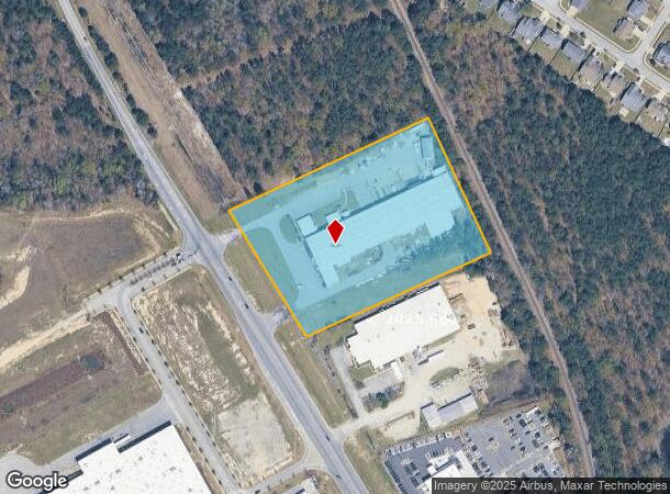
Property Record
10020 Farrow Rd, Columbia, SC 29203

NEARBY LISTINGS FOR SALE OR LEASE
Property Detail
10020 Farrow Rd
17400-04-03
PARCELS A & B #SU #PR 55-5763 RB961-2043
Commercialnec
Richland
X
South Carolina
45079C0139L
6.21 AC
2024
Northeast Columbia
2023
Columbia
010105
Columbia, SC
2,000 SF
DEMOGRAPHICS near 10020 Farrow Rd
1 Mile
3 Mile
5 Mile
2024 Total Population
5,948
44,749
103,125
2029 Population
6,092
45,509
104,831
Pop Growth 2024-2029
+ 2.42%
+ 1.70%
+ 1.65%
Average Age
35
37
38
2024 Total Households
2,194
17,044
39,779
HH Growth 2024-2029
+ 2.69%
+ 1.72%
+ 1.70%
Median Household Inc
$72,980
$68,950
$68,396
Avg Household Size
2.70
2.60
2.50
2024 Avg HH Vehicles
2.00
2.00
2.00
Median Home Value
$187,529
$189,765
$210,384
Median Year Built
2007
2003
2001
Nearby Places
Map Layers
Map Styles
 Street
 Aerial
- Restaurants
- Banks
- Shops
- Fitness
- Groceries
PUBLIC TRANSPORTATION
AIRPORT
Columbia Metro
DRIVE
WALK
Distance
Columbia Metro
39 min
23.7 mi
Freight Ports
North Charleston Terminal
DRIVE
WALK
Distance
North Charleston Terminal
138 min
120.8 mi
Nearby Properties
Address
Land Use
TOTAL SIZE
Lot Size
Zoning
Address
Land Use
TOTAL SIZE
Lot Size
Zoning
231,760 SF
23.84 AC
M-1
Address
Land Use
TOTAL SIZE
Lot Size
Zoning
144,849 SF
26.14 AC
OI
Address
Land Use
TOTAL SIZE
Lot Size
Zoning
83,808 SF
95.58 AC
PDD
Address
Land Use
TOTAL SIZE
Lot Size
Zoning
18,000 SF
52.20 AC
GC
Address
Land Use
TOTAL SIZE
Lot Size
Zoning
325,344 SF
71.41 AC
HI
Address
Land Use
TOTAL SIZE
Lot Size
Zoning
234,990 SF
16.50 AC
RM-HD
Address
Land Use
TOTAL SIZE
Lot Size
Zoning
33.32 AC
M-1
Address
Land Use
TOTAL SIZE
Lot Size
Zoning
306,612 SF
20.94 AC
GC
Address
Land Use
TOTAL SIZE
Lot Size
Zoning
349,845 SF
23.62 AC
HI
Address
Land Use
TOTAL SIZE
Lot Size
Zoning
301,627 SF
25.08 AC
PDD
Address
Land Use
TOTAL SIZE
Lot Size
Zoning
462,800 SF
104.82 AC
M-1
Address
Land Use
TOTAL SIZE
Lot Size
Zoning
253,136 SF
18.85 AC
PUD-1R
Address
Land Use
TOTAL SIZE
Lot Size
Zoning
269,200 SF
40.65 AC
M-1
Address
Land Use
TOTAL SIZE
Lot Size
Zoning
147,916 SF
4.69 AC
OI
Address
Land Use
TOTAL SIZE
Lot Size
Zoning
176,878 SF
15.48 AC
PDD
Address
Land Use
TOTAL SIZE
Lot Size
Zoning
51,803 SF
11.99 AC
M-1
Address
Land Use
TOTAL SIZE
Lot Size
Zoning
217,580 SF
32.47 AC
M-1
Address
Land Use
TOTAL SIZE
Lot Size
Zoning
242,894 SF
14.97 AC
RM-HD
Address
Land Use
TOTAL SIZE
Lot Size
Zoning
65,665 SF
7.03 AC
GC
Address
Land Use
TOTAL SIZE
Lot Size
Zoning
184,000 SF
9.67 AC
M-1
Address
Land Use
TOTAL SIZE
Lot Size
Zoning
275,753 SF
26.21 AC
HI
Address
Land Use
TOTAL SIZE
Lot Size
Zoning
178,080 SF
10.48 AC
M-1
Address
Land Use
TOTAL SIZE
Lot Size
Zoning
148,809 SF
17.52 AC
M-1
Address
Land Use
TOTAL SIZE
Lot Size
Zoning
129,017 SF
14.70 AC
PDD
Address
Land Use
TOTAL SIZE
Lot Size
Zoning
143,072 SF
12.61 AC
PDD
Address
Land Use
TOTAL SIZE
Lot Size
Zoning
71,394 SF
12.05 AC
M-1
Address
Land Use
TOTAL SIZE
Lot Size
Zoning
75,893 SF
10 AC
PDD
Address
Land Use
TOTAL SIZE
Lot Size
Zoning
88,710 SF
3.13 AC
GC
Address
Land Use
TOTAL SIZE
Lot Size
Zoning
68,091 SF
4.35 AC
OI
Address
Land Use
TOTAL SIZE
Lot Size
Zoning
169,600 SF
10.80 AC
M-1
The World's #1 Commercial Real Estate Marketplace
Connect with us
© 2025 CoStar Group
The information above has been obtained from sources believed reliable. While we do not doubt its accuracy we have not verified it and make no guarantee, warranty or representation about it. It is your responsibility to independently confirm its accuracy and completeness. Any projections, opinions, assumptions, or estimates used are for example only and do not represent the current or future performance of the property. The value of this transaction to you depends on tax and other factors which should be evaluated by your tax, financial, and legal advisors. You and your advisors should conduct a careful, independent investigation of the property to determine to your satisfaction the suitability of the property for your needs.