Property Record
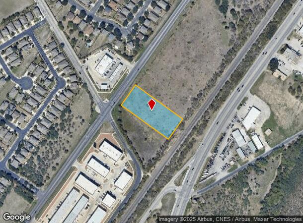
10022 Fm 1976, Universal City, TX 78148

NEARBY LISTINGS FOR SALE OR LEASE
Property Detail
10022 Fm 1976
San Antonio
Cb 5053Dd (Uc Industrial Subd)
San Antonio-New Braunfels, TX
CB 5053DD (UC INDUSTRIAL SUBD), BLOCK 1 LOT 2 2024- NEW PER PLAT 20003/344-345 FILED 4-14-2023. CR-59333. JLF/GIS/1-26-2024
05053-401-0021
Bexar
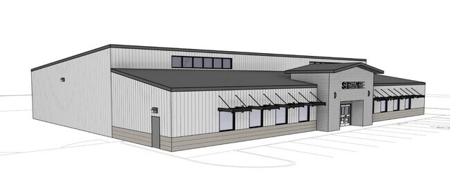
Officebuilding
Texas
2024
2
2025
1.56 AC
121601
Northeast
12,008 SF
DEMOGRAPHICS near 10022 Fm 1976
1 Mile
3 Mile
5 Mile
2024 Total Population
11,514
91,461
223,479
2029 Population
12,020
96,643
239,211
Pop Growth 2024-2029
+ 4.39%
+ 5.67%
+ 7.04%
Average Age
36
38
37
2024 Total Households
3,955
32,738
79,247
HH Growth 2024-2029
+ 4.58%
+ 5.68%
+ 7.14%
Median Household Inc
$71,744
$68,350
$71,190
Avg Household Size
2.90
2.70
2.80
2024 Avg HH Vehicles
2.00
2.00
2.00
Median Home Value
$209,045
$184,446
$201,740
Median Year Built
2002
1989
1997
Nearby Places
Map Layers
Map Styles
 Street
 Aerial
- Restaurants
- Banks
- Shops
- Fitness
- Groceries
PUBLIC TRANSPORTATION
AIRPORT
San Antonio International
DRIVE
WALK
Distance
San Antonio International
19 min
11.5 mi
Freight Ports
Calhoun Port
DRIVE
WALK
Distance
Calhoun Port
174 min
144.3 mi
SALE & LEASE HISTORY
LISTING DATE
SALE/LEASE

Dec 03, 2024
For Lease
Nearby Properties
Address
Land Use
TOTAL SIZE
Lot Size
Zoning
Address
Land Use
TOTAL SIZE
Lot Size
Zoning
727,299 SF
47.68 AC
Address
Land Use
TOTAL SIZE
Lot Size
Zoning
347,943 SF
10.07 AC
Address
Land Use
TOTAL SIZE
Lot Size
Zoning
223,185 SF
16.85 AC
Address
Land Use
TOTAL SIZE
Lot Size
Zoning
242,267 SF
15.77 AC
Address
Land Use
TOTAL SIZE
Lot Size
Zoning
240,077 SF
16.92 AC
Address
Land Use
TOTAL SIZE
Lot Size
Zoning
218,379 SF
9.65 AC
Address
Land Use
TOTAL SIZE
Lot Size
Zoning
277,887 SF
14.14 AC
Address
Land Use
TOTAL SIZE
Lot Size
Zoning
249,633 SF
7.04 AC
Address
Land Use
TOTAL SIZE
Lot Size
Zoning
251,707 SF
20.22 AC
Address
Land Use
TOTAL SIZE
Lot Size
Zoning
200,940 SF
10.31 AC
Address
Land Use
TOTAL SIZE
Lot Size
Zoning
198,868 SF
15.15 AC
Address
Land Use
TOTAL SIZE
Lot Size
Zoning
271,018 SF
13.75 AC
Address
Land Use
TOTAL SIZE
Lot Size
Zoning
190,134 SF
10.54 AC
Address
Land Use
TOTAL SIZE
Lot Size
Zoning
154,641 SF
9.07 AC
Address
Land Use
TOTAL SIZE
Lot Size
Zoning
156,381 SF
8.29 AC
Address
Land Use
TOTAL SIZE
Lot Size
Zoning
190,717 SF
9.99 AC
Address
Land Use
TOTAL SIZE
Lot Size
Zoning
145,811 SF
10.36 AC
Address
Land Use
TOTAL SIZE
Lot Size
Zoning
183,611 SF
10.13 AC
Address
Land Use
TOTAL SIZE
Lot Size
Zoning
342,612 SF
28.49 AC
Address
Land Use
TOTAL SIZE
Lot Size
Zoning
97,924 SF
3.10 AC
Address
Land Use
TOTAL SIZE
Lot Size
Zoning
186,055 SF
17.44 AC
Address
Land Use
TOTAL SIZE
Lot Size
Zoning
205,469 SF
12.55 AC
Address
Land Use
TOTAL SIZE
Lot Size
Zoning
102,700 SF
4.68 AC
Address
Land Use
TOTAL SIZE
Lot Size
Zoning
124,690 SF
24.47 AC
Address
Land Use
TOTAL SIZE
Lot Size
Zoning
134,157 SF
5.95 AC
Address
Land Use
TOTAL SIZE
Lot Size
Zoning
205,372 SF
21.38 AC
Address
Land Use
TOTAL SIZE
Lot Size
Zoning
2,747 SF
74.97 AC
Address
Land Use
TOTAL SIZE
Lot Size
Zoning
77,668 SF
3.53 AC
Address
Land Use
TOTAL SIZE
Lot Size
Zoning
66,540 SF
7.53 AC
Address
Land Use
TOTAL SIZE
Lot Size
Zoning
242,802 SF
9.42 AC
The World's #1 Commercial Real Estate Marketplace
Connect with us
© 2025 CoStar Group
The information above has been obtained from sources believed reliable. While we do not doubt its accuracy we have not verified it and make no guarantee, warranty or representation about it. It is your responsibility to independently confirm its accuracy and completeness. Any projections, opinions, assumptions, or estimates used are for example only and do not represent the current or future performance of the property. The value of this transaction to you depends on tax and other factors which should be evaluated by your tax, financial, and legal advisors. You and your advisors should conduct a careful, independent investigation of the property to determine to your satisfaction the suitability of the property for your needs.