Property Record
10022 I 10 Service Rd, New Orleans, LA 70127
NEARBY LISTINGS FOR SALE OR LEASE
-
-
View all New Orleans listings for sale on LoopNet.com
Property Detail
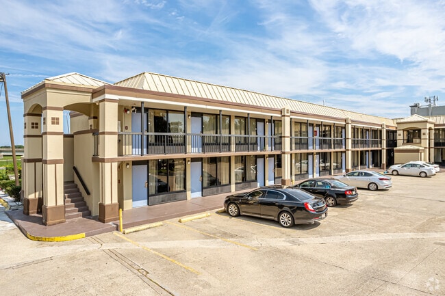
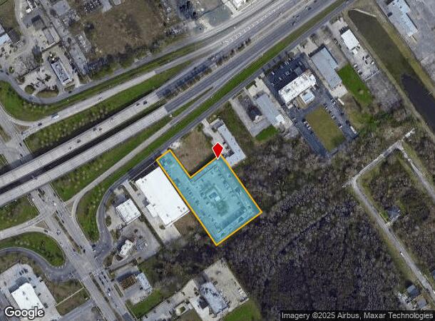
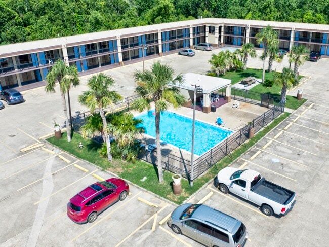
10022 I 10 Service Rd
New Orleans-Metairie, LA
Sec 24
3-9W-0-163-95
SEC 24 LOT 3 B 3 I 10 HWY SERVICE RD 80-181/261X165- 336/501 9-16A-33 (2.3145 ACR ES 83 39W016352 2/ST BR/ NEWCOURT INN MOTEL E002
Hotel
Orleans
AE
Louisiana
22087C0225D
3b3
2025
2.32 AC
2025
New Orleans East/Slidell
001736
New Orleans/Metairie/Kenner
48,692 SF
DEMOGRAPHICS near 10022 I 10 Service Rd
1 Mile
3 Mile
5 Mile
2024 Total Population
13,183
58,308
80,684
2029 Population
12,622
55,440
76,862
Pop Growth 2024-2029
(4.26%)
(4.92%)
(4.74%)
Average Age
39
39
39
2024 Total Households
4,993
21,241
29,323
HH Growth 2024-2029
(4.85%)
(5.20%)
(4.98%)
Median Household Inc
$29,780
$35,512
$35,061
Avg Household Size
2.50
2.60
2.60
2024 Avg HH Vehicles
1.00
1.00
1.00
Median Home Value
$191,276
$179,876
$180,086
Median Year Built
1977
1976
1976
Nearby Places
Map Layers
Map Styles
 Street
 Aerial
- Restaurants
- Banks
- Shops
- Fitness
- Groceries
PUBLIC TRANSPORTATION
AIRPORT
Louis Armstrong New Orleans International
DRIVE
WALK
Distance
Louis Armstrong New Orleans International
29 min
20.8 mi
Freight Ports
Port of New Orleans
DRIVE
WALK
Distance
Port of New Orleans
22 min
13.1 mi
SALE & LEASE HISTORY
LISTING DATE
SALE/LEASE

Sep 02, 2022
For Sale
Mar 26, 2018
For Sale
Mar 15, 2018
For Sale
Jun 21, 2018
For Sale
Jul 17, 2024
For Sale
Aug 28, 2018
For Sale
Nearby Properties
Address
Land Use
TOTAL SIZE
Lot Size
Zoning
Address
Land Use
TOTAL SIZE
Lot Size
Zoning
Address
Land Use
TOTAL SIZE
Lot Size
Zoning
Address
Land Use
TOTAL SIZE
Lot Size
Zoning
21.35 AC
S-RS
Address
Land Use
TOTAL SIZE
Lot Size
Zoning
139.95 AC
Address
Land Use
TOTAL SIZE
Lot Size
Zoning
21.58 AC
C-3
Address
Land Use
TOTAL SIZE
Lot Size
Zoning
136,984 SF
11.29 AC
S-RD
Address
Land Use
TOTAL SIZE
Lot Size
Zoning
136,984 SF
4.67 AC
S-RS
Address
Land Use
TOTAL SIZE
Lot Size
Zoning
109,239 SF
5.77 AC
S-RS
Address
Land Use
TOTAL SIZE
Lot Size
Zoning
115,600 SF
16.96 AC
S-B2
Address
Land Use
TOTAL SIZE
Lot Size
Zoning
95,308 SF
16.36 AC
S-RS
Address
Land Use
TOTAL SIZE
Lot Size
Zoning
99,015 SF
6.99 AC
S-RS
Address
Land Use
TOTAL SIZE
Lot Size
Zoning
94,050 SF
4.96 AC
S-RS
Address
Land Use
TOTAL SIZE
Lot Size
Zoning
105,907 SF
3.84 AC
OS-N
Address
Land Use
TOTAL SIZE
Lot Size
Zoning
13,302 SF
53.89 AC
OS-R
Address
Land Use
TOTAL SIZE
Lot Size
Zoning
20.58 AC
S-RS
Address
Land Use
TOTAL SIZE
Lot Size
Zoning
179,095 SF
18.13 AC
C-3
Address
Land Use
TOTAL SIZE
Lot Size
Zoning
2.48 AC
S-RD
Address
Land Use
TOTAL SIZE
Lot Size
Zoning
205,380 SF
16.49 AC
MS
Address
Land Use
TOTAL SIZE
Lot Size
Zoning
13,563 SF
81.46 AC
OS-R
Address
Land Use
TOTAL SIZE
Lot Size
Zoning
33.59 AC
S-RS
Address
Land Use
TOTAL SIZE
Lot Size
Zoning
17.83 AC
OS-R
Address
Land Use
TOTAL SIZE
Lot Size
Zoning
93,584 SF
20.96 AC
S-RS
Address
Land Use
TOTAL SIZE
Lot Size
Zoning
20.48 AC
S-RS
Address
Land Use
TOTAL SIZE
Lot Size
Zoning
280,168 SF
11.47 AC
S-RM2
Address
Land Use
TOTAL SIZE
Lot Size
Zoning
5.92 AC
C-1
Address
Land Use
TOTAL SIZE
Lot Size
Zoning
83,918 SF
8.08 AC
S-RD
Address
Land Use
TOTAL SIZE
Lot Size
Zoning
4.09 AC
S-RD
Address
Land Use
TOTAL SIZE
Lot Size
Zoning
147,600 SF
14.18 AC
C-3
Address
Land Use
TOTAL SIZE
Lot Size
Zoning
73,252 SF
5.37 AC
C-2
Address
Land Use
TOTAL SIZE
Lot Size
Zoning
506,319 SF
30.87 AC
S-RM2
The World's #1 Commercial Real Estate Marketplace
Connect with us
© 2026 CoStar Group
The information above has been obtained from sources believed reliable. While we do not doubt its accuracy we have not verified it and make no guarantee, warranty or representation about it. It is your responsibility to independently confirm its accuracy and completeness. Any projections, opinions, assumptions, or estimates used are for example only and do not represent the current or future performance of the property. The value of this transaction to you depends on tax and other factors which should be evaluated by your tax, financial, and legal advisors. You and your advisors should conduct a careful, independent investigation of the property to determine to your satisfaction the suitability of the property for your needs.