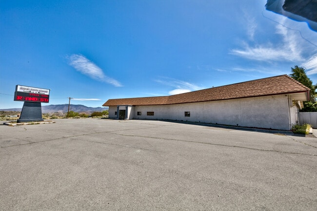
Property Record
10025 Us Highway 50 E, Carson City, NV 89706


NEARBY LISTINGS FOR SALE OR LEASE
Property Detail
10025 Us Highway 50 E
Reno, NV
Carson Highlands 2
019-491-02
ROCK N RODEO
Commercialnec
Lyon
X
Nevada
3200010110F
2
2026
0.62 AC
2025
Lyon County
000900
Reno/Sparks
6,081 SF
DEMOGRAPHICS near 10025 Us Highway 50 E
1 mile
3 mile
5 mile
2024 Total Population
1,196
2,151
22,408
2029 Population
1,269
2,244
22,603
Pop Growth 2024-2029
+ 6.10%
+ 4.32%
+ 0.87%
Average Age
43
43
42
2024 Total Households
473
833
8,843
HH Growth 2024-2029
+ 6.13%
+ 4.32%
+ 0.75%
Median Household Inc
$65,706
$72,603
$69,891
Avg Household Size
2.50
2.50
2.50
2024 Avg HH Vehicles
2.00
2.00
2.00
Median Home Value
$300,893
$325,168
$336,421
Median Year Built
1988
1985
1984
Nearby Places
Map Layers
Map Styles
 Street
 Aerial
Transit
 Traffic
 Biking
Places
Listings with unknown addresses are not visible on the map
- Restaurants
- Banks
- Shops
- Fitness
- Groceries
PUBLIC TRANSPORTATION
AIRPORT
Reno/Tahoe International
Drive
Walk
Distance
Reno/Tahoe International
58 min
35.8 mi
SALE & LEASE HISTORY
LISTING DATE
SALE/LEASE

May 27, 2022
For Lease
May 13, 2024
For Sale
Apr 16, 2019
For Sale
Nearby Properties
Address
Land Use
TOTAL SIZE
Lot Size
Zoning
Address
Land Use
TOTAL SIZE
Lot Size
Zoning
96,057 SF
10 AC
LI
Address
Land Use
TOTAL SIZE
Lot Size
Zoning
240 AC
PR
Address
Land Use
TOTAL SIZE
Lot Size
Zoning
375 SF
520 AC
PR
Address
Land Use
TOTAL SIZE
Lot Size
Zoning
178.40 AC
PR
Address
Land Use
TOTAL SIZE
Lot Size
Zoning
30,228 SF
395.78 AC
PR
Address
Land Use
TOTAL SIZE
Lot Size
Zoning
270 AC
PC
Address
Land Use
TOTAL SIZE
Lot Size
Zoning
3,504 SF
39.83 AC
PR
Address
Land Use
TOTAL SIZE
Lot Size
Zoning
1,197.80 AC
CR
Address
Land Use
TOTAL SIZE
Lot Size
Zoning
200 AC
PC
Address
Land Use
TOTAL SIZE
Lot Size
Zoning
4.51 AC
RR3
Address
Land Use
TOTAL SIZE
Lot Size
Zoning
100,947 SF
15 AC
M1
Address
Land Use
TOTAL SIZE
Lot Size
Zoning
900 AC
CR
Address
Land Use
TOTAL SIZE
Lot Size
Zoning
108.58 AC
PR
Address
Land Use
TOTAL SIZE
Lot Size
Zoning
55,800 SF
3.06 AC
LI
Address
Land Use
TOTAL SIZE
Lot Size
Zoning
37,681 SF
4.22 AC
GI
Address
Land Use
TOTAL SIZE
Lot Size
Zoning
48,799 SF
2.21 AC
LI
Address
Land Use
TOTAL SIZE
Lot Size
Zoning
48,799 SF
2.30 AC
LI
Address
Land Use
TOTAL SIZE
Lot Size
Zoning
83,961 SF
10 AC
M1
Address
Land Use
TOTAL SIZE
Lot Size
Zoning
75,290 SF
5.74 AC
GI
Address
Land Use
TOTAL SIZE
Lot Size
Zoning
1,590 SF
10.16 AC
M1
Address
Land Use
TOTAL SIZE
Lot Size
Zoning
137.94 AC
CR
Address
Land Use
TOTAL SIZE
Lot Size
Zoning
54,897 SF
6.24 AC
LI
Address
Land Use
TOTAL SIZE
Lot Size
Zoning
28,000 SF
7.78 AC
M1
Address
Land Use
TOTAL SIZE
Lot Size
Zoning
19.33 AC
PR
Address
Land Use
TOTAL SIZE
Lot Size
Zoning
22,200 SF
4.27 AC
M1
Address
Land Use
TOTAL SIZE
Lot Size
Zoning
69,600 SF
5.85 AC
M1
Address
Land Use
TOTAL SIZE
Lot Size
Zoning
40 AC
PR
Address
Land Use
TOTAL SIZE
Lot Size
Zoning
40 AC
PR
Address
Land Use
TOTAL SIZE
Lot Size
Zoning
36,450 SF
7 AC
GI
Address
Land Use
TOTAL SIZE
Lot Size
Zoning
513.24 AC
PR
The World's #1 Commercial Real Estate Marketplace
Connect with us
© 2026 CoStar Group
The information above has been obtained from sources believed reliable. While we do not doubt its accuracy we have not verified it and make no guarantee, warranty or representation about it. It is your responsibility to independently confirm its accuracy and completeness. Any projections, opinions, assumptions, or estimates used are for example only and do not represent the current or future performance of the property. The value of this transaction to you depends on tax and other factors which should be evaluated by your tax, financial, and legal advisors. You and your advisors should conduct a careful, independent investigation of the property to determine to your satisfaction the suitability of the property for your needs.