Property Record
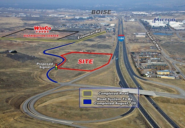
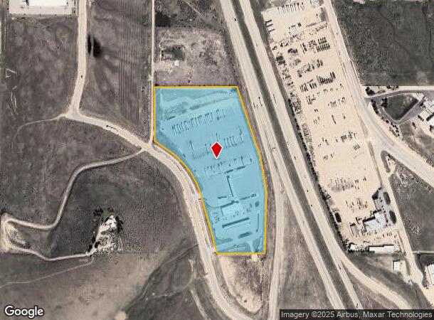
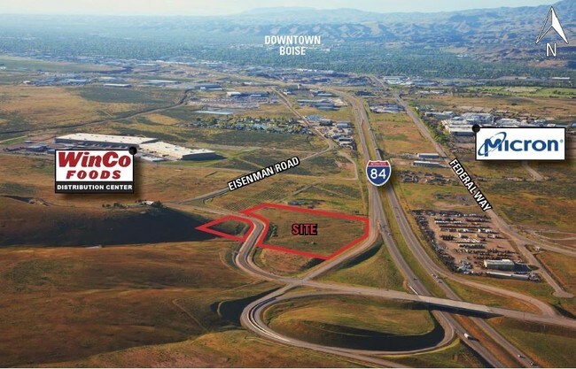
10026 S Eisenman Rd, Boise, ID 83716

NEARBY LISTINGS FOR SALE OR LEASE
Property Detail
10026 S Eisenman Rd
S1618244400
PAR #4400 OF SE4NW4 SEC 18 2N 3E #241000-B
Commercialbuilding
Ada
X
Idaho
16001C0295J
19.64 AC
2024
Airport
2025
Boise City/Nampa
010503
Boise City, ID
11,010 SF
DEMOGRAPHICS near 10026 S Eisenman Rd
1 Mile
3 Mile
5 Mile
2024 Total Population
6
7,559
32,706
2029 Population
7
8,667
37,148
Pop Growth 2024-2029
+ 16.67%
+ 14.66%
+ 13.58%
Average Age
42
37
41
2024 Total Households
2
2,744
12,561
HH Growth 2024-2029
0.00%
+ 15.09%
+ 13.81%
Median Household Inc
$175,000
$98,381
$109,030
Avg Household Size
2.00
2.70
2.50
2024 Avg HH Vehicles
3.00
2.00
2.00
Median Home Value
$750,000
$450,087
$527,174
Median Year Built
2011
1998
1995
Nearby Places
Map Layers
Map Styles
 Street
 Aerial
- Restaurants
- Banks
- Shops
- Fitness
- Groceries
PUBLIC TRANSPORTATION
AIRPORT
Boise Air Trml/Gowen Field
DRIVE
WALK
Distance
Boise Air Trml/Gowen Field
20 min
6.9 mi
Freight Ports
Port of Portland
DRIVE
WALK
Distance
Port of Portland
484 min
438.8 mi
SALE & LEASE HISTORY
LISTING DATE
SALE/LEASE

Sep 24, 2016
For Sale
Nearby Properties
Address
Land Use
TOTAL SIZE
Lot Size
Zoning
Address
Land Use
TOTAL SIZE
Lot Size
Zoning
ZC-258
Address
Land Use
TOTAL SIZE
Lot Size
Zoning
851,556 SF
78.75 AC
ZC-269
Address
Land Use
TOTAL SIZE
Lot Size
Zoning
900,981 SF
86.35 AC
ZC-263
Address
Land Use
TOTAL SIZE
Lot Size
Zoning
122,110 SF
12.66 AC
ZC-257
Address
Land Use
TOTAL SIZE
Lot Size
Zoning
356,969 SF
49.72 AC
ZC-269
Address
Land Use
TOTAL SIZE
Lot Size
Zoning
245,240 SF
5.40 AC
R-2
Address
Land Use
TOTAL SIZE
Lot Size
Zoning
277,827 SF
M-2D
Address
Land Use
TOTAL SIZE
Lot Size
Zoning
366,032 SF
10.79 AC
ZC-248
Address
Land Use
TOTAL SIZE
Lot Size
Zoning
237,251 SF
20.90 AC
ZC-269
Address
Land Use
TOTAL SIZE
Lot Size
Zoning
220,160 SF
12.70 AC
ZC-269
Address
Land Use
TOTAL SIZE
Lot Size
Zoning
50,674 SF
49.82 AC
ZC-258
Address
Land Use
TOTAL SIZE
Lot Size
Zoning
168,000 SF
ZC-269
Address
Land Use
TOTAL SIZE
Lot Size
Zoning
187,820 SF
11.39 AC
ZC-269
Address
Land Use
TOTAL SIZE
Lot Size
Zoning
96.73 AC
ZC-258
Address
Land Use
TOTAL SIZE
Lot Size
Zoning
165,000 SF
10.60 AC
ZC-269
Address
Land Use
TOTAL SIZE
Lot Size
Zoning
19,359 SF
4.75 AC
ZC-248
Address
Land Use
TOTAL SIZE
Lot Size
Zoning
171,774 SF
10.14 AC
ZC-269
Address
Land Use
TOTAL SIZE
Lot Size
Zoning
133,300 SF
18.38 AC
ZC-269
Address
Land Use
TOTAL SIZE
Lot Size
Zoning
81.26 AC
ZC-258
Address
Land Use
TOTAL SIZE
Lot Size
Zoning
160 AC
ZC-257
Address
Land Use
TOTAL SIZE
Lot Size
Zoning
79.86 AC
ZC-258
Address
Land Use
TOTAL SIZE
Lot Size
Zoning
119,200 SF
6.97 AC
ZC-269
Address
Land Use
TOTAL SIZE
Lot Size
Zoning
186,755 SF
ZC-269
Address
Land Use
TOTAL SIZE
Lot Size
Zoning
66.20 AC
ZC-258
Address
Land Use
TOTAL SIZE
Lot Size
Zoning
112,315 SF
12.56 AC
ZC-258
Address
Land Use
TOTAL SIZE
Lot Size
Zoning
225,127 SF
20.62 AC
ZC-269
Address
Land Use
TOTAL SIZE
Lot Size
Zoning
110,428 SF
8.13 AC
ZC-269
Address
Land Use
TOTAL SIZE
Lot Size
Zoning
3,579,086 SF
43.24 AC
ZC-258
Address
Land Use
TOTAL SIZE
Lot Size
Zoning
110,428 SF
10.31 AC
ZC-269
Address
Land Use
TOTAL SIZE
Lot Size
Zoning
123,214 SF
7.54 AC
ZC-242
The World's #1 Commercial Real Estate Marketplace
Connect with us
© 2026 CoStar Group
The information above has been obtained from sources believed reliable. While we do not doubt its accuracy we have not verified it and make no guarantee, warranty or representation about it. It is your responsibility to independently confirm its accuracy and completeness. Any projections, opinions, assumptions, or estimates used are for example only and do not represent the current or future performance of the property. The value of this transaction to you depends on tax and other factors which should be evaluated by your tax, financial, and legal advisors. You and your advisors should conduct a careful, independent investigation of the property to determine to your satisfaction the suitability of the property for your needs.