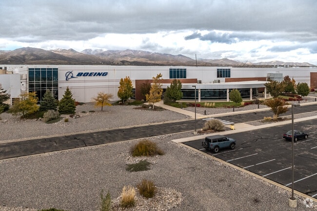
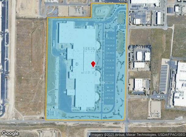
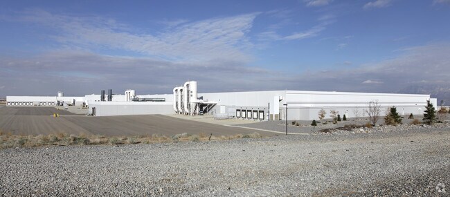
Property Record
10026 S Prosperity Rd, West Jordan, UT 84081
NEARBY LISTINGS FOR SALE OR LEASE
Property Detail
10026 S Prosperity Rd
Salt Lake City-Murray, UT
Rwk Subdivision
26-11-351-003-0000
LOT 1, RWK SUBDIVISION AMD 9208-7104 9551-9394 9920-8715
Heavyindustrial
Salt Lake
X
Utah
49035C0410G
1
2024
75.49 AC
2025
West Jordan
115211
Salt Lake City
857,680 SF
DEMOGRAPHICS near 10026 S Prosperity Rd
1 Mile
3 Mile
5 Mile
2024 Total Population
1,566
72,637
191,361
2029 Population
1,664
74,903
195,241
Pop Growth 2024-2029
+ 6.26%
+ 3.12%
+ 2.03%
Average Age
27
33
33
2024 Total Households
475
21,265
54,622
HH Growth 2024-2029
+ 6.32%
+ 3.11%
+ 2.01%
Median Household Inc
$49,614
$107,656
$104,293
Avg Household Size
3.20
3.40
3.50
2024 Avg HH Vehicles
2.00
2.00
2.00
Median Home Value
$605,263
$485,965
$466,530
Median Year Built
2010
2010
2006
Nearby Places
Map Layers
Map Styles
 Street
 Aerial
- Restaurants
- Banks
- Shops
- Fitness
- Groceries
PUBLIC TRANSPORTATION
COMMUTER RAIL
South Jordan Station (FrontRunner - Utah Transit Authority (UTA))
DRIVE
WALK
Distance
South Jordan Station (FrontRunner - Utah Transit Authority (UTA))
19 min
9.3 mi
AIRPORT
Salt Lake City International
DRIVE
WALK
Distance
Salt Lake City International
26 min
18.2 mi
Freight Ports
Port of Stockton
DRIVE
WALK
Distance
Port of Stockton
719 min
697.9 mi
Nearby Properties
Address
Land Use
TOTAL SIZE
Lot Size
Zoning
Address
Land Use
TOTAL SIZE
Lot Size
Zoning
1,328,525 SF
76.12 AC
A-20
Address
Land Use
TOTAL SIZE
Lot Size
Zoning
285,200 SF
55.78 AC
1210
Address
Land Use
TOTAL SIZE
Lot Size
Zoning
233,853 SF
6.05 AC
HFR
Address
Land Use
TOTAL SIZE
Lot Size
Zoning
126,150 SF
25.43 AC
RM
Address
Land Use
TOTAL SIZE
Lot Size
Zoning
1,042,750 SF
55.65 AC
M-1
Address
Land Use
TOTAL SIZE
Lot Size
Zoning
362,000 SF
51.81 AC
P-F
Address
Land Use
TOTAL SIZE
Lot Size
Zoning
591,044 SF
13.87 AC
C-2
Address
Land Use
TOTAL SIZE
Lot Size
Zoning
469,074 SF
5.14 AC
C-P
Address
Land Use
TOTAL SIZE
Lot Size
Zoning
702,100 SF
13.83 AC
P-C
Address
Land Use
TOTAL SIZE
Lot Size
Zoning
73,318 SF
1.36 AC
PC
Address
Land Use
TOTAL SIZE
Lot Size
Zoning
609,061 SF
40 AC
M-1
Address
Land Use
TOTAL SIZE
Lot Size
Zoning
204,793 SF
53.90 AC
M-1
Address
Land Use
TOTAL SIZE
Lot Size
Zoning
321,528 SF
15.77 AC
R-3-16
Address
Land Use
TOTAL SIZE
Lot Size
Zoning
256,167 SF
13.56 AC
P-C
Address
Land Use
TOTAL SIZE
Lot Size
Zoning
137,750 SF
12.64 AC
1210
Address
Land Use
TOTAL SIZE
Lot Size
Zoning
188,632 SF
12.11 AC
PC
Address
Land Use
TOTAL SIZE
Lot Size
Zoning
256,933 SF
19.68 AC
P-C
Address
Land Use
TOTAL SIZE
Lot Size
Zoning
59,711 SF
4.77 AC
C-2
Address
Land Use
TOTAL SIZE
Lot Size
Zoning
425,753 SF
2.28 AC
PC
Address
Land Use
TOTAL SIZE
Lot Size
Zoning
348,043 SF
5.35 AC
PC
Address
Land Use
TOTAL SIZE
Lot Size
Zoning
536,706 SF
12.80 AC
SC-2
Address
Land Use
TOTAL SIZE
Lot Size
Zoning
348,917 SF
6.23 AC
PC
Address
Land Use
TOTAL SIZE
Lot Size
Zoning
200,665 SF
20.95 AC
4192
Address
Land Use
TOTAL SIZE
Lot Size
Zoning
554,777 SF
168.76 AC
M-1
Address
Land Use
TOTAL SIZE
Lot Size
Zoning
4.76 AC
PC
Address
Land Use
TOTAL SIZE
Lot Size
Zoning
411,226 SF
7.22 AC
SC-2
Address
Land Use
TOTAL SIZE
Lot Size
Zoning
239,900 SF
29.12 AC
P-C
Address
Land Use
TOTAL SIZE
Lot Size
Zoning
341,646 SF
19.70 AC
M-1
Address
Land Use
TOTAL SIZE
Lot Size
Zoning
The World's #1 Commercial Real Estate Marketplace
Connect with us
© 2026 CoStar Group
The information above has been obtained from sources believed reliable. While we do not doubt its accuracy we have not verified it and make no guarantee, warranty or representation about it. It is your responsibility to independently confirm its accuracy and completeness. Any projections, opinions, assumptions, or estimates used are for example only and do not represent the current or future performance of the property. The value of this transaction to you depends on tax and other factors which should be evaluated by your tax, financial, and legal advisors. You and your advisors should conduct a careful, independent investigation of the property to determine to your satisfaction the suitability of the property for your needs.