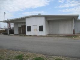
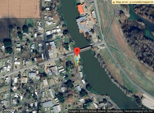
Property Record
1003 Canal St, Breaux Bridge, LA 70517
NEARBY LISTINGS FOR SALE OR LEASE
-
-
View all Breaux Bridge listings for sale on LoopNet.com
Property Detail
1003 Canal St
06201B3453
Sarah Heights
Miscresidentialimprovement
LOT SHOWN AS !0.129 AC.! PER PLAT OF SURVEY #426519COB 1234-257-278858 1394-101-357790 1404-334-365272 1408-324-368048 1542-0
AE
St Martin
22099C0150H
Louisiana
2024
0.13 AC
2024
St Martin Parish
020304
Lafayette
2,262 SF
Lafayette, LA
DEMOGRAPHICS near 1003 Canal St
1 Mile
3 Mile
5 Mile
2024 Total Population
924
4,691
9,613
2029 Population
878
4,557
9,370
Pop Growth 2024-2029
(4.98%)
(2.86%)
(2.53%)
Average Age
38
40
40
2024 Total Households
324
1,788
3,701
HH Growth 2024-2029
(4.94%)
(2.74%)
(2.43%)
Median Household Inc
$33,425
$52,390
$50,719
Avg Household Size
2.70
2.50
2.50
2024 Avg HH Vehicles
2.00
2.00
2.00
Median Home Value
$78,204
$128,315
$141,196
Median Year Built
1977
1983
1987
Nearby Places
Map Layers
Map Styles
 Street
 Aerial
- Restaurants
- Banks
- Shops
- Fitness
- Groceries
PUBLIC TRANSPORTATION
AIRPORT
Lafayette Regional/Paul Fournet Field
DRIVE
WALK
Distance
Lafayette Regional/Paul Fournet Field
27 min
17.8 mi
Nearby Properties
Address
Land Use
TOTAL SIZE
Lot Size
Zoning
Address
Land Use
TOTAL SIZE
Lot Size
Zoning
4,800 SF
84.43 AC
Address
Land Use
TOTAL SIZE
Lot Size
Zoning
Address
Land Use
TOTAL SIZE
Lot Size
Zoning
Address
Land Use
TOTAL SIZE
Lot Size
Zoning
26,950 SF
4.86 AC
Address
Land Use
TOTAL SIZE
Lot Size
Zoning
8,700 SF
5.60 AC
Address
Land Use
TOTAL SIZE
Lot Size
Zoning
37,728 SF
14.63 AC
Address
Land Use
TOTAL SIZE
Lot Size
Zoning
14,560 SF
2.14 AC
Address
Land Use
TOTAL SIZE
Lot Size
Zoning
8,990 SF
7.28 AC
Address
Land Use
TOTAL SIZE
Lot Size
Zoning
3,050 SF
6 AC
Address
Land Use
TOTAL SIZE
Lot Size
Zoning
3,390 SF
1.92 AC
Address
Land Use
TOTAL SIZE
Lot Size
Zoning
Address
Land Use
TOTAL SIZE
Lot Size
Zoning
Address
Land Use
TOTAL SIZE
Lot Size
Zoning
1,280 SF
2.32 AC
Address
Land Use
TOTAL SIZE
Lot Size
Zoning
2,864 SF
0.57 AC
Address
Land Use
TOTAL SIZE
Lot Size
Zoning
Address
Land Use
TOTAL SIZE
Lot Size
Zoning
7,033 SF
2.31 AC
Address
Land Use
TOTAL SIZE
Lot Size
Zoning
2,326 SF
0.58 AC
Address
Land Use
TOTAL SIZE
Lot Size
Zoning
2,536 SF
0.52 AC
Address
Land Use
TOTAL SIZE
Lot Size
Zoning
1,433 SF
2.48 AC
Address
Land Use
TOTAL SIZE
Lot Size
Zoning
12,000 SF
11.04 AC
Address
Land Use
TOTAL SIZE
Lot Size
Zoning
2,000 SF
0.97 AC
Address
Land Use
TOTAL SIZE
Lot Size
Zoning
4,340 SF
0.59 AC
Address
Land Use
TOTAL SIZE
Lot Size
Zoning
2,317 SF
1.07 AC
Address
Land Use
TOTAL SIZE
Lot Size
Zoning
Address
Land Use
TOTAL SIZE
Lot Size
Zoning
13,871 SF
2.95 AC
Address
Land Use
TOTAL SIZE
Lot Size
Zoning
6,300 SF
2 AC
Address
Land Use
TOTAL SIZE
Lot Size
Zoning
10,000 SF
3.04 AC
Address
Land Use
TOTAL SIZE
Lot Size
Zoning
4,340 SF
4.12 AC
Address
Land Use
TOTAL SIZE
Lot Size
Zoning
Address
Land Use
TOTAL SIZE
Lot Size
Zoning
4,864 SF
3.43 AC
The World's #1 Commercial Real Estate Marketplace
Connect with us
© 2026 CoStar Group
The information above has been obtained from sources believed reliable. While we do not doubt its accuracy we have not verified it and make no guarantee, warranty or representation about it. It is your responsibility to independently confirm its accuracy and completeness. Any projections, opinions, assumptions, or estimates used are for example only and do not represent the current or future performance of the property. The value of this transaction to you depends on tax and other factors which should be evaluated by your tax, financial, and legal advisors. You and your advisors should conduct a careful, independent investigation of the property to determine to your satisfaction the suitability of the property for your needs.