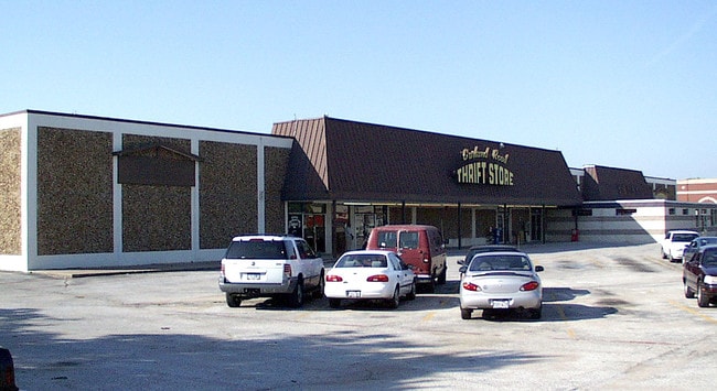
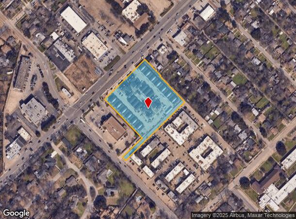
Property Record
10030 Garland Rd, Dallas, TX 75218
NEARBY LISTINGS FOR SALE OR LEASE
Property Detail
10030 Garland Rd
Dallas-Fort Worth-Arlington, TX
Garland And Peavy Road
005363000001A0000
GARLAND AND PEAVY ROAD BLK 5363 LT 1A ACS 3.6100 INT202200101381 DD04082022 CO-DC 5363 000 01A00 7DA5363 000
Apartment
Dallas
AE
Texas
48113C0355K
1a
2024
3.61 AC
2025
Northeast Dallas
008200
Dallas/Ft Worth
92,190 SF
DEMOGRAPHICS near 10030 Garland Rd
1 Mile
3 Mile
5 Mile
2024 Total Population
12,777
124,574
377,947
2029 Population
12,759
123,296
374,885
Pop Growth 2024-2029
(0.14%)
(1.03%)
(0.81%)
Average Age
40
37
36
2024 Total Households
5,364
47,304
149,625
HH Growth 2024-2029
+ 0.09%
(1.15%)
(0.84%)
Median Household Inc
$62,553
$62,814
$60,616
Avg Household Size
2.30
2.60
2.50
2024 Avg HH Vehicles
2.00
2.00
2.00
Median Home Value
$350,127
$320,082
$292,633
Median Year Built
1961
1966
1974
Nearby Places
Map Layers
Map Styles
 Street
 Aerial
- Restaurants
- Banks
- Shops
- Fitness
- Groceries
PUBLIC TRANSPORTATION
COMMUTER RAIL
DRIVE
WALK
Distance
18 min
9.2 mi
AIRPORT
Dallas Love Field
DRIVE
WALK
Distance
Dallas Love Field
26 min
10.6 mi
Dallas-Fort Worth International
DRIVE
WALK
Distance
Dallas-Fort Worth International
39 min
30.3 mi
Nearby Properties
Address
Land Use
TOTAL SIZE
Lot Size
Zoning
Address
Land Use
TOTAL SIZE
Lot Size
Zoning
32,530 SF
0.02 AC
Z239
Address
Land Use
TOTAL SIZE
Lot Size
Zoning
392,842 SF
16.79 AC
Z164
Address
Land Use
TOTAL SIZE
Lot Size
Zoning
691,816 SF
19.50 AC
Z239
Address
Land Use
TOTAL SIZE
Lot Size
Zoning
368,350 SF
1.21 AC
Z59
Address
Land Use
TOTAL SIZE
Lot Size
Zoning
252,473 SF
7.28 AC
Z165
Address
Land Use
TOTAL SIZE
Lot Size
Zoning
491,903 SF
22.48 AC
Z164
Address
Land Use
TOTAL SIZE
Lot Size
Zoning
391,774 SF
3.97 AC
Z239
Address
Land Use
TOTAL SIZE
Lot Size
Zoning
445,781 SF
4.57 AC
Z239
Address
Land Use
TOTAL SIZE
Lot Size
Zoning
245,023 SF
6.84 AC
Z164
Address
Land Use
TOTAL SIZE
Lot Size
Zoning
247,421 SF
3.96 AC
Z133
Address
Land Use
TOTAL SIZE
Lot Size
Zoning
284,990 SF
24.80 AC
Z298
Address
Land Use
TOTAL SIZE
Lot Size
Zoning
922,851 SF
52.30 AC
Z144
Address
Land Use
TOTAL SIZE
Lot Size
Zoning
480,000 SF
25.27 AC
Z239
Address
Land Use
TOTAL SIZE
Lot Size
Zoning
292,827 SF
13.81 AC
Z163
Address
Land Use
TOTAL SIZE
Lot Size
Zoning
531,950 SF
24.62 AC
Z239
Address
Land Use
TOTAL SIZE
Lot Size
Zoning
349,156 SF
10.86 AC
Z59
Address
Land Use
TOTAL SIZE
Lot Size
Zoning
922,851 SF
52.28 AC
Z144
Address
Land Use
TOTAL SIZE
Lot Size
Zoning
121,440 SF
17.02 AC
Z298
Address
Land Use
TOTAL SIZE
Lot Size
Zoning
195,495 SF
9.61 AC
Z298
Address
Land Use
TOTAL SIZE
Lot Size
Zoning
265,986 SF
13.75 AC
Z163
Address
Land Use
TOTAL SIZE
Lot Size
Zoning
161,796 SF
14.84 AC
Z239
Address
Land Use
TOTAL SIZE
Lot Size
Zoning
244,575 SF
9.91 AC
Z164
Address
Land Use
TOTAL SIZE
Lot Size
Zoning
220,989 SF
12.94 AC
Z163
Address
Land Use
TOTAL SIZE
Lot Size
Zoning
174,353 SF
12.64 AC
Z248
Address
Land Use
TOTAL SIZE
Lot Size
Zoning
116,162 SF
228.26 AC
Z372
Address
Land Use
TOTAL SIZE
Lot Size
Zoning
171,348 SF
5.70 AC
Z164
Address
Land Use
TOTAL SIZE
Lot Size
Zoning
297,704 SF
13.74 AC
Z163
Address
Land Use
TOTAL SIZE
Lot Size
Zoning
289,172 SF
12.56 AC
Z164
Address
Land Use
TOTAL SIZE
Lot Size
Zoning
228,857 SF
21.91 AC
Z298
Address
Land Use
TOTAL SIZE
Lot Size
Zoning
110,708 SF
16.79 AC
Z298
The World's #1 Commercial Real Estate Marketplace
Connect with us
© 2025 CoStar Group
The information above has been obtained from sources believed reliable. While we do not doubt its accuracy we have not verified it and make no guarantee, warranty or representation about it. It is your responsibility to independently confirm its accuracy and completeness. Any projections, opinions, assumptions, or estimates used are for example only and do not represent the current or future performance of the property. The value of this transaction to you depends on tax and other factors which should be evaluated by your tax, financial, and legal advisors. You and your advisors should conduct a careful, independent investigation of the property to determine to your satisfaction the suitability of the property for your needs.