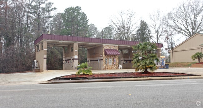
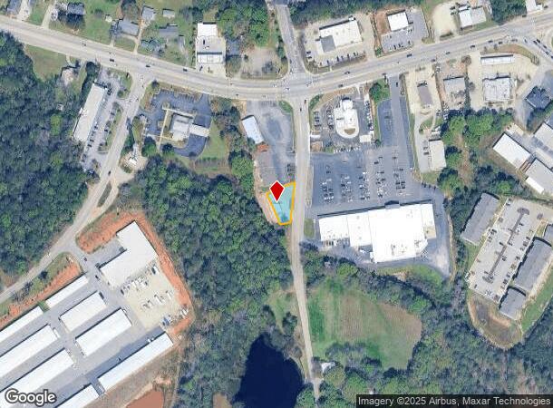
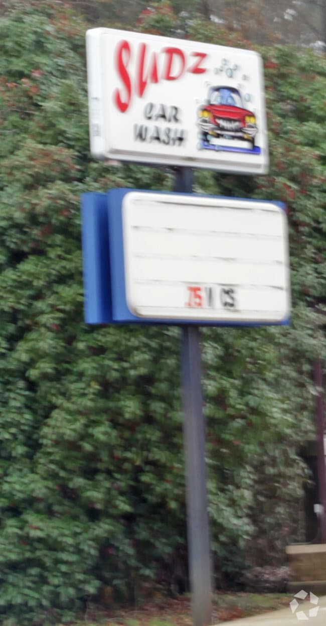
Property Record
1004 A J Amick Rd, Irmo, SC 29063
NEARBY LISTINGS FOR SALE OR LEASE
-
-
View all Irmo listings for sale on LoopNet.com
Property Detail
1004 A J Amick Rd
02414-03-04
Irmo Whiterock Ballentine
Commercialnec
130.5X38.2X120.2X103.1 #SU #PR 51-7462 55-5696 883-2467
X
Richland
45063C0126J
South Carolina
2025
0.20 AC
2024
Dutch Fork/Irmo
010310
Columbia
1,672 SF
Columbia, SC
DEMOGRAPHICS near 1004 A J Amick Rd
1 mile
3 mile
5 mile
2024 Total Population
2,815
27,682
60,099
2029 Population
2,882
28,297
62,343
Pop Growth 2024-2029
+ 2.38%
+ 2.22%
+ 3.73%
Average Age
40
40
41
2024 Total Households
1,084
10,257
23,102
HH Growth 2024-2029
+ 2.21%
+ 2.34%
+ 4.00%
Median Household Inc
$113,194
$98,485
$96,122
Avg Household Size
2.60
2.70
2.60
2024 Avg HH Vehicles
2.00
2.00
2.00
Median Home Value
$299,303
$273,274
$253,359
Median Year Built
2010
1998
1995
Nearby Places
Map Layers
Map Styles
 Street
 Aerial
Transit
 Traffic
 Biking
Places
Listings with unknown addresses are not visible on the map
- Restaurants
- Banks
- Shops
- Fitness
- Groceries
PUBLIC TRANSPORTATION
AIRPORT
Columbia Metro
Drive
Walk
Distance
Columbia Metro
35 min
20.2 mi
Nearby Properties
Address
Land Use
TOTAL SIZE
Lot Size
Zoning
Address
Land Use
TOTAL SIZE
Lot Size
Zoning
3,957 SF
20.32 AC
GC
Address
Land Use
TOTAL SIZE
Lot Size
Zoning
333,986 SF
11.33 AC
GC
Address
Land Use
TOTAL SIZE
Lot Size
Zoning
31,005 SF
55.97 AC
PDD
Address
Land Use
TOTAL SIZE
Lot Size
Zoning
191,009 SF
28.02 AC
CG
Address
Land Use
TOTAL SIZE
Lot Size
Zoning
1,958 SF
145.19 AC
PDD
Address
Land Use
TOTAL SIZE
Lot Size
Zoning
1,728 SF
5.24 AC
GC
Address
Land Use
TOTAL SIZE
Lot Size
Zoning
64,680 SF
11 AC
GC
Address
Land Use
TOTAL SIZE
Lot Size
Zoning
21,580 SF
16.15 AC
GC
Address
Land Use
TOTAL SIZE
Lot Size
Zoning
56,750 SF
8.16 AC
M-1
Address
Land Use
TOTAL SIZE
Lot Size
Zoning
76,066 SF
7.29 AC
M-1
Address
Land Use
TOTAL SIZE
Lot Size
Zoning
57,020 SF
11.80 AC
PDD
Address
Land Use
TOTAL SIZE
Lot Size
Zoning
1,602 SF
4.28 AC
RR
Address
Land Use
TOTAL SIZE
Lot Size
Zoning
56,958 SF
6.21 AC
CG
Address
Land Use
TOTAL SIZE
Lot Size
Zoning
9.83 AC
CG
Address
Land Use
TOTAL SIZE
Lot Size
Zoning
56,588 SF
6.46 AC
GC
Address
Land Use
TOTAL SIZE
Lot Size
Zoning
15,205 SF
2.05 AC
C-3
Address
Land Use
TOTAL SIZE
Lot Size
Zoning
31,032 SF
7.36 AC
GC
Address
Land Use
TOTAL SIZE
Lot Size
Zoning
8.57 AC
CG
Address
Land Use
TOTAL SIZE
Lot Size
Zoning
17,683 SF
16.46 AC
RU
Address
Land Use
TOTAL SIZE
Lot Size
Zoning
11,917 SF
5.72 AC
RU
Address
Land Use
TOTAL SIZE
Lot Size
Zoning
14,370 SF
6.84 AC
RU
Address
Land Use
TOTAL SIZE
Lot Size
Zoning
720 SF
2.97 AC
RU
Address
Land Use
TOTAL SIZE
Lot Size
Zoning
24,049 SF
5.13 AC
CG
Address
Land Use
TOTAL SIZE
Lot Size
Zoning
24,049 SF
4.30 AC
CG
Address
Land Use
TOTAL SIZE
Lot Size
Zoning
23,439 SF
7.68 AC
RU
Address
Land Use
TOTAL SIZE
Lot Size
Zoning
15,252 SF
5.70 AC
RS-LD
Address
Land Use
TOTAL SIZE
Lot Size
Zoning
1,755 SF
4.29 AC
RS-LD
Address
Land Use
TOTAL SIZE
Lot Size
Zoning
19,142 SF
15.08 AC
PDD
Address
Land Use
TOTAL SIZE
Lot Size
Zoning
5,050 SF
4.68 AC
RU
Address
Land Use
TOTAL SIZE
Lot Size
Zoning
17,805 SF
23.60 AC
RS
The World's #1 Commercial Real Estate Marketplace
Connect with us
© 2026 CoStar Group
The information above has been obtained from sources believed reliable. While we do not doubt its accuracy we have not verified it and make no guarantee, warranty or representation about it. It is your responsibility to independently confirm its accuracy and completeness. Any projections, opinions, assumptions, or estimates used are for example only and do not represent the current or future performance of the property. The value of this transaction to you depends on tax and other factors which should be evaluated by your tax, financial, and legal advisors. You and your advisors should conduct a careful, independent investigation of the property to determine to your satisfaction the suitability of the property for your needs.