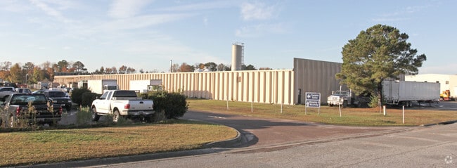
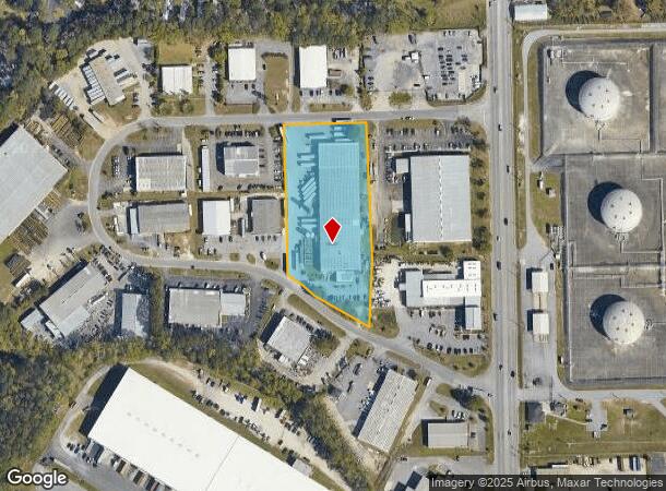
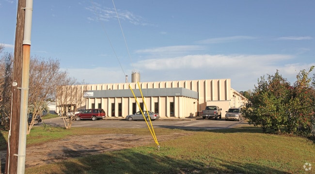
Property Record
1004 Bankton Cir, Hanahan, SC 29410
NEARBY LISTINGS FOR SALE OR LEASE
Property Detail
1004 Bankton Cir
266-09-00-023
Hanahan - Trident Industrial Park
Commercialnec
TRACT A
X
Berkeley
45019C0315K
South Carolina
2025
2.97 AC
2025
Outlying Berkeley County
021000
Charleston/N Charleston
47,984 SF
Charleston-North Charleston, SC
DEMOGRAPHICS near 1004 Bankton Cir
1 Mile
3 Mile
5 Mile
2024 Total Population
5,413
36,674
99,775
2029 Population
6,223
41,002
111,046
Pop Growth 2024-2029
+ 14.96%
+ 11.80%
+ 11.30%
Average Age
38
37
36
2024 Total Households
2,229
14,946
38,317
HH Growth 2024-2029
+ 14.94%
+ 11.53%
+ 11.19%
Median Household Inc
$51,242
$61,479
$55,000
Avg Household Size
2.40
2.40
2.40
2024 Avg HH Vehicles
2.00
2.00
2.00
Median Home Value
$209,694
$261,984
$222,480
Median Year Built
1973
1980
1983
Nearby Places
Map Layers
Map Styles
 Street
 Aerial
- Restaurants
- Banks
- Shops
- Fitness
- Groceries
PUBLIC TRANSPORTATION
COMMUTER RAIL
Charleston Amtrak Station (Palmetto - Amtrak, Silver Meteor - Amtrak)
DRIVE
WALK
Distance
Charleston Amtrak Station (Palmetto - Amtrak, Silver Meteor - Amtrak)
7 min
3.5 mi
AIRPORT
Charleston AFB/International
DRIVE
WALK
Distance
Charleston AFB/International
16 min
9.4 mi
Freight Ports
North Charleston Terminal
DRIVE
WALK
Distance
North Charleston Terminal
1 min
0.8 mi
Nearby Properties
Address
Land Use
TOTAL SIZE
Lot Size
Zoning
Address
Land Use
TOTAL SIZE
Lot Size
Zoning
313,920 SF
23.09 AC
HANAHAN -
Address
Land Use
TOTAL SIZE
Lot Size
Zoning
202,154 SF
16.34 AC
Address
Land Use
TOTAL SIZE
Lot Size
Zoning
197,100 SF
34.14 AC
HANAHAN -
Address
Land Use
TOTAL SIZE
Lot Size
Zoning
302,400 SF
18.71 AC
HANAHAN -
Address
Land Use
TOTAL SIZE
Lot Size
Zoning
302,400 SF
23.70 AC
HANAHAN -
Address
Land Use
TOTAL SIZE
Lot Size
Zoning
64,584 SF
10.92 AC
HANAHAN -
Address
Land Use
TOTAL SIZE
Lot Size
Zoning
137,576 SF
5 AC
HANAHAN -
Address
Land Use
TOTAL SIZE
Lot Size
Zoning
68,655 SF
9.48 AC
Address
Land Use
TOTAL SIZE
Lot Size
Zoning
36,882 SF
5.80 AC
HANAHAN -
Address
Land Use
TOTAL SIZE
Lot Size
Zoning
105,666 SF
8.25 AC
Address
Land Use
TOTAL SIZE
Lot Size
Zoning
390,180 SF
20.76 AC
HANAHAN -
Address
Land Use
TOTAL SIZE
Lot Size
Zoning
36,912 SF
6.19 AC
HANAHAN -
Address
Land Use
TOTAL SIZE
Lot Size
Zoning
21,364 SF
7.71 AC
Address
Land Use
TOTAL SIZE
Lot Size
Zoning
92,800 SF
15.24 AC
HANAHAN -
Address
Land Use
TOTAL SIZE
Lot Size
Zoning
3,672 SF
3.62 AC
HANAHAN -
Address
Land Use
TOTAL SIZE
Lot Size
Zoning
10,560 SF
7.50 AC
Address
Land Use
TOTAL SIZE
Lot Size
Zoning
68,208 SF
21.38 AC
HANAHAN -
Address
Land Use
TOTAL SIZE
Lot Size
Zoning
922.90 AC
HANAHAN -
Address
Land Use
TOTAL SIZE
Lot Size
Zoning
7,176 SF
3.55 AC
HANAHAN -
Address
Land Use
TOTAL SIZE
Lot Size
Zoning
54,449 SF
10.56 AC
HANAHAN -
Address
Land Use
TOTAL SIZE
Lot Size
Zoning
48,885 SF
5.02 AC
Address
Land Use
TOTAL SIZE
Lot Size
Zoning
210,664 SF
8.87 AC
HANAHAN -
Address
Land Use
TOTAL SIZE
Lot Size
Zoning
9,691 SF
10.34 AC
Address
Land Use
TOTAL SIZE
Lot Size
Zoning
133.75 AC
MUC_DC
Address
Land Use
TOTAL SIZE
Lot Size
Zoning
14,775 SF
1.52 AC
HANAHAN -
Address
Land Use
TOTAL SIZE
Lot Size
Zoning
78,764 SF
4.15 AC
HANAHAN -
Address
Land Use
TOTAL SIZE
Lot Size
Zoning
1,303 SF
4.77 AC
Address
Land Use
TOTAL SIZE
Lot Size
Zoning
15,027 SF
3.62 AC
HANAHAN -
Address
Land Use
TOTAL SIZE
Lot Size
Zoning
175,800 SF
7.30 AC
HANAHAN -
The World's #1 Commercial Real Estate Marketplace
Connect with us
© 2026 CoStar Group
The information above has been obtained from sources believed reliable. While we do not doubt its accuracy we have not verified it and make no guarantee, warranty or representation about it. It is your responsibility to independently confirm its accuracy and completeness. Any projections, opinions, assumptions, or estimates used are for example only and do not represent the current or future performance of the property. The value of this transaction to you depends on tax and other factors which should be evaluated by your tax, financial, and legal advisors. You and your advisors should conduct a careful, independent investigation of the property to determine to your satisfaction the suitability of the property for your needs.