Property Record
1000 Carondelet Dr, Kansas City, MO 64114


Current Lease Availabilities
NEARBY LISTINGS FOR SALE OR LEASE
Property Detail
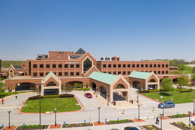
1000 Carondelet Dr
Kansas City, MO-KS
Carondelet Three
48-940-06-10-03-0-00-000
IMPROVEMENT ONLY CARONDELET THREE----ALL OF LT 1 LY BETW EVE L 164.24 & 177.93 ( KANSAS CITY DATUM) BEG AT SW COR SD LO T 1 TH N N81 DEG 53 MIN 55 SEC E 25.37 TH N 08 DEG 06 MIN 0
Officebuilding
Jackson
X
Missouri
29095C0386G
1,164
2024
1.09 AC
2025
South Kansas City MO
010105
Kansas City
154,281 SF
DEMOGRAPHICS near 1000 Carondelet Dr
1 Mile
3 Mile
5 Mile
2024 Total Population
7,149
64,509
191,401
2029 Population
7,310
65,885
196,355
Pop Growth 2024-2029
+ 2.25%
+ 2.13%
+ 2.59%
Average Age
48
43
42
2024 Total Households
3,588
28,730
85,010
HH Growth 2024-2029
+ 2.23%
+ 2.01%
+ 2.65%
Median Household Inc
$75,764
$92,061
$81,002
Avg Household Size
1.90
2.20
2.20
2024 Avg HH Vehicles
2.00
2.00
2.00
Median Home Value
$320,795
$360,365
$323,095
Median Year Built
1973
1973
1970
Nearby Places
Map Layers
Map Styles
 Street
 Aerial
- Restaurants
- Banks
- Shops
- Fitness
- Groceries
PUBLIC TRANSPORTATION
AIRPORT
Kansas City International
DRIVE
WALK
Distance
Kansas City International
49 min
38.2 mi
Freight Ports
Tulsa Port Of Catoosa
DRIVE
WALK
Distance
Tulsa Port Of Catoosa
253 min
226.1 mi
Nearby Properties
Address
Land Use
TOTAL SIZE
Lot Size
Zoning
Address
Land Use
TOTAL SIZE
Lot Size
Zoning
47.39 AC
AG
Address
Land Use
TOTAL SIZE
Lot Size
Zoning
177,588 SF
9.27 AC
CP-O
Address
Land Use
TOTAL SIZE
Lot Size
Zoning
189,882 SF
13.04 AC
CP-O
Address
Land Use
TOTAL SIZE
Lot Size
Zoning
316,432 SF
29.39 AC
R-1
Address
Land Use
TOTAL SIZE
Lot Size
Zoning
616,742 SF
13.59 AC
Address
Land Use
TOTAL SIZE
Lot Size
Zoning
122,309 SF
76.14 AC
R-1
Address
Land Use
TOTAL SIZE
Lot Size
Zoning
325,588 SF
36.63 AC
SD-CR
Address
Land Use
TOTAL SIZE
Lot Size
Zoning
79,917 SF
7.86 AC
SD-NCR
Address
Land Use
TOTAL SIZE
Lot Size
Zoning
120,305 SF
7.01 AC
CP-O
Address
Land Use
TOTAL SIZE
Lot Size
Zoning
110,710 SF
4.66 AC
CP-O
Address
Land Use
TOTAL SIZE
Lot Size
Zoning
59,570 SF
8.46 AC
SD-O
Address
Land Use
TOTAL SIZE
Lot Size
Zoning
113,263 SF
3.53 AC
CP-O
Address
Land Use
TOTAL SIZE
Lot Size
Zoning
73,383 SF
9.53 AC
R-1
Address
Land Use
TOTAL SIZE
Lot Size
Zoning
552,475 SF
Address
Land Use
TOTAL SIZE
Lot Size
Zoning
166,097 SF
37.29 AC
R-1
Address
Land Use
TOTAL SIZE
Lot Size
Zoning
105,110 SF
8.93 AC
AG
Address
Land Use
TOTAL SIZE
Lot Size
Zoning
465,394 SF
16.63 AC
Address
Land Use
TOTAL SIZE
Lot Size
Zoning
69,958 SF
10.93 AC
R-1
Address
Land Use
TOTAL SIZE
Lot Size
Zoning
436,499 SF
22.71 AC
Address
Land Use
TOTAL SIZE
Lot Size
Zoning
179,965 SF
6.15 AC
CP-O
Address
Land Use
TOTAL SIZE
Lot Size
Zoning
120,225 SF
9.13 AC
R-1
Address
Land Use
TOTAL SIZE
Lot Size
Zoning
119,320 SF
19.74 AC
R-1
Address
Land Use
TOTAL SIZE
Lot Size
Zoning
387,197 SF
Address
Land Use
TOTAL SIZE
Lot Size
Zoning
159,274 SF
14.38 AC
SD-CR
Address
Land Use
TOTAL SIZE
Lot Size
Zoning
457,500 SF
Address
Land Use
TOTAL SIZE
Lot Size
Zoning
157,280 SF
25.10 AC
Address
Land Use
TOTAL SIZE
Lot Size
Zoning
109,553 SF
3.08 AC
Address
Land Use
TOTAL SIZE
Lot Size
Zoning
449,148 SF
30.98 AC
CP-O
Address
Land Use
TOTAL SIZE
Lot Size
Zoning
405,226 SF
6.87 AC
MXD
Address
Land Use
TOTAL SIZE
Lot Size
Zoning
432,629 SF
5.06 AC
MXD
The World's #1 Commercial Real Estate Marketplace
Connect with us
© 2025 CoStar Group
The information above has been obtained from sources believed reliable. While we do not doubt its accuracy we have not verified it and make no guarantee, warranty or representation about it. It is your responsibility to independently confirm its accuracy and completeness. Any projections, opinions, assumptions, or estimates used are for example only and do not represent the current or future performance of the property. The value of this transaction to you depends on tax and other factors which should be evaluated by your tax, financial, and legal advisors. You and your advisors should conduct a careful, independent investigation of the property to determine to your satisfaction the suitability of the property for your needs.