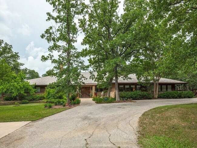
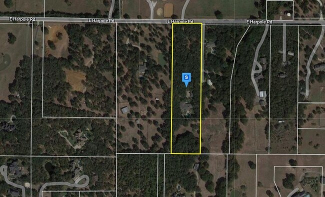
Property Record
1004 Harpole Rd E, Argyle, TX 76226

Property Detail
1004 Harpole Rd E
Dallas-Fort Worth-Arlington, TX
FOX HOLLOW EST BLK A LOT 3
R94341
Denton
Agriculturalland
Texas
B and X Area of moderate flood hazard, usually the area between the limits of the 100-year and 500-year floods.
3
2024
6.51 AC
2025
Flower Mound
020316
Dallas/Ft Worth
5,092 SF
NEARBY LISTINGS FOR SALE OR LEASE
DEMOGRAPHICS near 1004 Harpole Rd E
1 mile
3 mile
5 mile
2024 Total Population
885
21,724
75,409
2029 Population
1,053
26,226
91,523
Pop Growth 2024-2029
+ 18.98%
+ 20.72%
+ 21.37%
Average Age
41
40
40
2024 Total Households
293
7,099
25,280
HH Growth 2024-2029
+ 19.45%
+ 21.26%
+ 21.97%
Median Household Inc
$138,999
$149,474
$129,690
Avg Household Size
3.00
3.10
3.00
2024 Avg HH Vehicles
3.00
2.00
2.00
Median Home Value
$859,243
$531,341
$451,414
Median Year Built
1991
2006
2008
Nearby Places
Map Layers
Map Styles
 Street
 Aerial
Transit
 Traffic
 Biking
Places
Listings with unknown addresses are not visible on the map
- Restaurants
- Banks
- Shops
- Fitness
- Groceries
PUBLIC TRANSPORTATION
AIRPORT
Dallas-Fort Worth International
Drive
Walk
Distance
Dallas-Fort Worth International
36 min
25.2 mi
Dallas Love Field
Drive
Walk
Distance
Dallas Love Field
52 min
34.0 mi
Nearby Properties
Address
Land Use
TOTAL SIZE
Lot Size
Zoning
Address
Land Use
TOTAL SIZE
Lot Size
Zoning
313,901 SF
59.12 AC
Address
Land Use
TOTAL SIZE
Lot Size
Zoning
202,197 SF
39.88 AC
Address
Land Use
TOTAL SIZE
Lot Size
Zoning
157,100 SF
10.44 AC
Address
Land Use
TOTAL SIZE
Lot Size
Zoning
53,567 SF
26.29 AC
Address
Land Use
TOTAL SIZE
Lot Size
Zoning
44,782 SF
4.64 AC
Address
Land Use
TOTAL SIZE
Lot Size
Zoning
81,288 SF
11.64 AC
Address
Land Use
TOTAL SIZE
Lot Size
Zoning
95,116 SF
4.14 AC
Address
Land Use
TOTAL SIZE
Lot Size
Zoning
93,600 SF
3.16 AC
Address
Land Use
TOTAL SIZE
Lot Size
Zoning
34,592 SF
49.57 AC
Address
Land Use
TOTAL SIZE
Lot Size
Zoning
76,074 SF
12.08 AC
Address
Land Use
TOTAL SIZE
Lot Size
Zoning
63.39 AC
Address
Land Use
TOTAL SIZE
Lot Size
Zoning
50,452 SF
4.10 AC
Address
Land Use
TOTAL SIZE
Lot Size
Zoning
76,522 SF
7.32 AC
Address
Land Use
TOTAL SIZE
Lot Size
Zoning
17,601 SF
5 AC
Address
Land Use
TOTAL SIZE
Lot Size
Zoning
39,058 SF
7.24 AC
Address
Land Use
TOTAL SIZE
Lot Size
Zoning
64,000 SF
10.83 AC
Address
Land Use
TOTAL SIZE
Lot Size
Zoning
7,655 SF
82.64 AC
Address
Land Use
TOTAL SIZE
Lot Size
Zoning
19,520 SF
1.88 AC
Address
Land Use
TOTAL SIZE
Lot Size
Zoning
25,138 SF
25.51 AC
Address
Land Use
TOTAL SIZE
Lot Size
Zoning
50 AC
Address
Land Use
TOTAL SIZE
Lot Size
Zoning
13,402 SF
3.78 AC
Address
Land Use
TOTAL SIZE
Lot Size
Zoning
44,250 SF
2.42 AC
Address
Land Use
TOTAL SIZE
Lot Size
Zoning
26,100 SF
1.59 AC
Address
Land Use
TOTAL SIZE
Lot Size
Zoning
7,100 SF
71.34 AC
Address
Land Use
TOTAL SIZE
Lot Size
Zoning
69,000 SF
5.23 AC
Address
Land Use
TOTAL SIZE
Lot Size
Zoning
78,180 SF
5 AC
Address
Land Use
TOTAL SIZE
Lot Size
Zoning
4,140 SF
11.50 AC
Address
Land Use
TOTAL SIZE
Lot Size
Zoning
21,775 SF
12.96 AC
Address
Land Use
TOTAL SIZE
Lot Size
Zoning
20,940 SF
4.09 AC
Address
Land Use
TOTAL SIZE
Lot Size
Zoning
25,830 SF
27 AC
The World's #1 Commercial Real Estate Marketplace
Connect with us
© 2026 CoStar Group
The information above has been obtained from sources believed reliable. While we do not doubt its accuracy we have not verified it and make no guarantee, warranty or representation about it. It is your responsibility to independently confirm its accuracy and completeness. Any projections, opinions, assumptions, or estimates used are for example only and do not represent the current or future performance of the property. The value of this transaction to you depends on tax and other factors which should be evaluated by your tax, financial, and legal advisors. You and your advisors should conduct a careful, independent investigation of the property to determine to your satisfaction the suitability of the property for your needs.