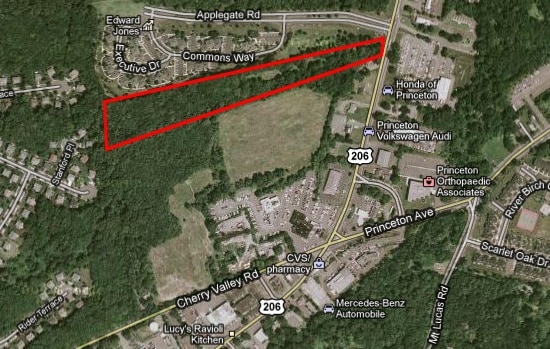
Property Record
994 State Rd, Princeton, NJ 08540
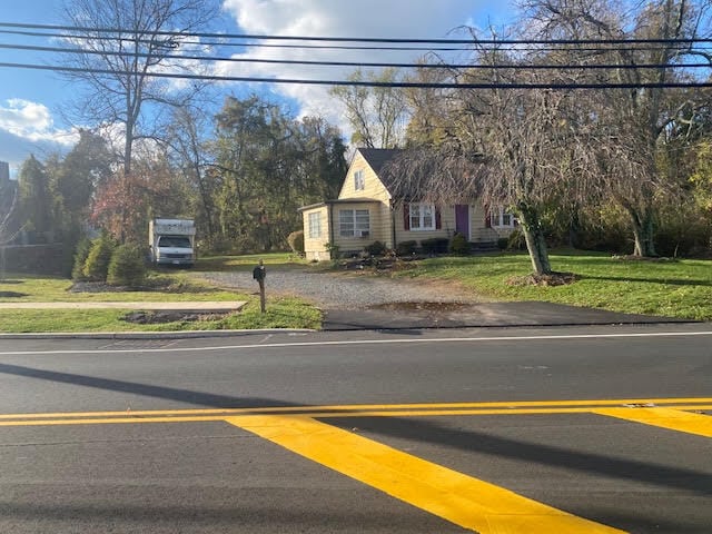

This Property Is For Sale
NEARBY LISTINGS FOR SALE OR LEASE
Property Detail
994 State Rd
Newark, NJ-PA
Somerset
13-34001-0000-00059
New Jersey
Sfr
0.46 AC
X
Princeton North
34035C0244F
Northern New Jersey
1,050 SF
DEMOGRAPHICS near 994 State Rd
1 Mile
3 Mile
5 Mile
2024 Total Population
6,014
30,308
77,240
2029 Population
5,951
30,241
77,267
Pop Growth 2024-2029
(1.05%)
(0.22%)
+ 0.03%
Average Age
42
42
41
2024 Total Households
2,258
11,314
27,334
HH Growth 2024-2029
(1.37%)
(0.43%)
+ 0.03%
Median Household Inc
$161,495
$167,367
$171,715
Avg Household Size
2.60
2.60
2.70
2024 Avg HH Vehicles
2.00
2.00
2.00
Median Home Value
$554,446
$731,863
$722,392
Median Year Built
1993
1983
1986
Nearby Places
- Restaurants
- Banks
- Shops
- Fitness
- Groceries
PUBLIC TRANSPORTATION
COMMUTER RAIL
Princeton (Princeton Branch - NJ Transit Commuter Rail (NJ Transit))
DRIVE
WALK
Distance
Princeton (Princeton Branch - NJ Transit Commuter Rail (NJ Transit))
7 min
4.0 mi
Princeton Junction (Northeast Corridor Line - NJ Transit Commuter Rail (NJ Transit), Princeton Branch - NJ Transit Commuter Rail (NJ Transit))
DRIVE
WALK
Distance
Princeton Junction (Northeast Corridor Line - NJ Transit Commuter Rail (NJ Transit), Princeton Branch - NJ Transit Commuter Rail (NJ Transit))
14 min
7.0 mi
AIRPORT
Trenton Mercer
DRIVE
WALK
Distance
Trenton Mercer
28 min
16.2 mi
Freight Ports
New York Container Terminal
DRIVE
WALK
Distance
New York Container Terminal
52 min
34.7 mi
Nearby Properties
Address
Land Use
TOTAL SIZE
Lot Size
Zoning
Address
Land Use
TOTAL SIZE
Lot Size
Zoning
24.85 AC
E
Address
Land Use
TOTAL SIZE
Lot Size
Zoning
265,000 SF
4.84 AC
Address
Land Use
TOTAL SIZE
Lot Size
Zoning
23.64 AC
PMUD
Address
Land Use
TOTAL SIZE
Lot Size
Zoning
8.97 AC
HMC
Address
Land Use
TOTAL SIZE
Lot Size
Zoning
44.62 AC
R5A
Address
Land Use
TOTAL SIZE
Lot Size
Zoning
115,000 SF
7.98 AC
OR2
Address
Land Use
TOTAL SIZE
Lot Size
Zoning
216,000 SF
22.79 AC
SC
Address
Land Use
TOTAL SIZE
Lot Size
Zoning
Address
Land Use
TOTAL SIZE
Lot Size
Zoning
151,475 SF
2.12 AC
E1
Address
Land Use
TOTAL SIZE
Lot Size
Zoning
21.79 AC
R3
Address
Land Use
TOTAL SIZE
Lot Size
Zoning
12.20 AC
E
Address
Land Use
TOTAL SIZE
Lot Size
Zoning
36.45 AC
E4
Address
Land Use
TOTAL SIZE
Lot Size
Zoning
0.26 AC
OR2
Address
Land Use
TOTAL SIZE
Lot Size
Zoning
4.94 AC
E1
Address
Land Use
TOTAL SIZE
Lot Size
Zoning
72,000 SF
0.09 AC
CB
Address
Land Use
TOTAL SIZE
Lot Size
Zoning
86,765 SF
2.07 AC
E2
Address
Land Use
TOTAL SIZE
Lot Size
Zoning
30 AC
E4
Address
Land Use
TOTAL SIZE
Lot Size
Zoning
128,724 SF
11.89 AC
E1
Address
Land Use
TOTAL SIZE
Lot Size
Zoning
30.02 AC
OB-1
Address
Land Use
TOTAL SIZE
Lot Size
Zoning
23,067 SF
4.46 AC
Address
Land Use
TOTAL SIZE
Lot Size
Zoning
345.28 AC
M3
Address
Land Use
TOTAL SIZE
Lot Size
Zoning
4.39 AC
Address
Land Use
TOTAL SIZE
Lot Size
Zoning
27.04 AC
R1
Address
Land Use
TOTAL SIZE
Lot Size
Zoning
35.71 AC
OR1
Address
Land Use
TOTAL SIZE
Lot Size
Zoning
10 AC
OR1
Address
Land Use
TOTAL SIZE
Lot Size
Zoning
17.45 AC
HC
Address
Land Use
TOTAL SIZE
Lot Size
Zoning
5 AC
REO2
Address
Land Use
TOTAL SIZE
Lot Size
Zoning
4.09 AC
Address
Land Use
TOTAL SIZE
Lot Size
Zoning
1.34 AC
E4
Address
Land Use
TOTAL SIZE
Lot Size
Zoning
9.92 AC
S2
The World's #1 Commercial Real Estate Marketplace
Connect with us
© 2025 CoStar Group
The information above has been obtained from sources believed reliable. While we do not doubt its accuracy we have not verified it and make no guarantee, warranty or representation about it. It is your responsibility to independently confirm its accuracy and completeness. Any projections, opinions, assumptions, or estimates used are for example only and do not represent the current or future performance of the property. The value of this transaction to you depends on tax and other factors which should be evaluated by your tax, financial, and legal advisors. You and your advisors should conduct a careful, independent investigation of the property to determine to your satisfaction the suitability of the property for your needs.