No Photo
Property Record
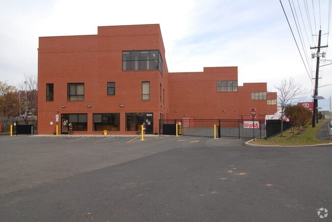
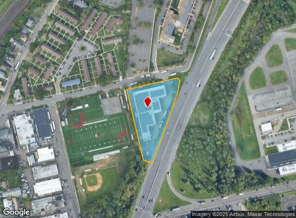
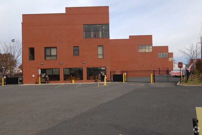
1004 State Highway Rte 1, Rahway, NJ 07065

NEARBY LISTINGS FOR SALE OR LEASE
-
-
View all Rahway listings for sale on LoopNet.com
Property Detail
1004 State Highway Rte 1
13-00301-0000-00003-01
Union
Warehouse
New Jersey
X
3.1
34023C0057F
1.99 AC
2024
Parkway Cranford Corridor
2025
Northern New Jersey
035900
Newark, NJ-PA
1 SF
DEMOGRAPHICS near 1004 State Highway Rte 1
1 Mile
3 Mile
5 Mile
2024 Total Population
19,722
144,570
364,481
2029 Population
19,710
143,144
359,759
Pop Growth 2024-2029
(0.06%)
(0.99%)
(1.30%)
Average Age
39
41
40
2024 Total Households
7,244
52,019
129,781
HH Growth 2024-2029
(0.12%)
(1.10%)
(1.39%)
Median Household Inc
$77,756
$91,254
$93,184
Avg Household Size
2.50
2.70
2.70
2024 Avg HH Vehicles
1.00
2.00
2.00
Median Home Value
$330,901
$373,427
$406,243
Median Year Built
1976
1959
1961
Nearby Places
Map Layers
Map Styles
 Street
 Aerial
- Restaurants
- Banks
- Shops
- Fitness
- Groceries
PUBLIC TRANSPORTATION
COMMUTER RAIL
Rahway (North Jersey Coast Line - NJ Transit Commuter Rail (NJ Transit), Northeast Corridor Line - NJ Transit Commuter Rail (NJ Transit))
DRIVE
WALK
Distance
Rahway (North Jersey Coast Line - NJ Transit Commuter Rail (NJ Transit), Northeast Corridor Line - NJ Transit Commuter Rail (NJ Transit))
3 min
17 min
0.9 mi
Avenel (North Jersey Coast Line - NJ Transit Commuter Rail (NJ Transit))
DRIVE
WALK
Distance
Avenel (North Jersey Coast Line - NJ Transit Commuter Rail (NJ Transit))
5 min
2.0 mi
AIRPORT
Newark Liberty International
DRIVE
WALK
Distance
Newark Liberty International
21 min
12.7 mi
LaGuardia
DRIVE
WALK
Distance
LaGuardia
54 min
33.1 mi
John F Kennedy International
DRIVE
WALK
Distance
John F Kennedy International
53 min
35.8 mi
Freight Ports
New York Container Terminal
DRIVE
WALK
Distance
New York Container Terminal
14 min
8.4 mi
Nearby Properties
Address
Land Use
TOTAL SIZE
Lot Size
Zoning
Address
Land Use
TOTAL SIZE
Lot Size
Zoning
329,350 SF
15.99 AC
Address
Land Use
TOTAL SIZE
Lot Size
Zoning
10 SF
0.64 AC
Address
Land Use
TOTAL SIZE
Lot Size
Zoning
Address
Land Use
TOTAL SIZE
Lot Size
Zoning
404,985 SF
15.32 AC
R25
Address
Land Use
TOTAL SIZE
Lot Size
Zoning
37 AC
Address
Land Use
TOTAL SIZE
Lot Size
Zoning
1 SF
37 AC
Address
Land Use
TOTAL SIZE
Lot Size
Zoning
102.29 AC
Address
Land Use
TOTAL SIZE
Lot Size
Zoning
20.10 AC
Address
Land Use
TOTAL SIZE
Lot Size
Zoning
348,466 SF
15.98 AC
LI
Address
Land Use
TOTAL SIZE
Lot Size
Zoning
360,082 SF
22.45 AC
R50
Address
Land Use
TOTAL SIZE
Lot Size
Zoning
365,784 SF
12.73 AC
HIA
Address
Land Use
TOTAL SIZE
Lot Size
Zoning
78.47 AC
Address
Land Use
TOTAL SIZE
Lot Size
Zoning
298,080 SF
13.79 AC
LI
Address
Land Use
TOTAL SIZE
Lot Size
Zoning
10,240 SF
22.96 AC
LI
Address
Land Use
TOTAL SIZE
Lot Size
Zoning
232,134 SF
12.24 AC
LI
Address
Land Use
TOTAL SIZE
Lot Size
Zoning
8.43 AC
Address
Land Use
TOTAL SIZE
Lot Size
Zoning
29.03 AC
IL
Address
Land Use
TOTAL SIZE
Lot Size
Zoning
0.14 AC
C-4
Address
Land Use
TOTAL SIZE
Lot Size
Zoning
151.20 AC
O
Address
Land Use
TOTAL SIZE
Lot Size
Zoning
131,140 SF
10 AC
LI
Address
Land Use
TOTAL SIZE
Lot Size
Zoning
400 SF
22.39 AC
R50
Address
Land Use
TOTAL SIZE
Lot Size
Zoning
262,455 SF
7.01 AC
R50
Address
Land Use
TOTAL SIZE
Lot Size
Zoning
231,654 SF
10.94 AC
LI
Address
Land Use
TOTAL SIZE
Lot Size
Zoning
19.90 AC
P
Address
Land Use
TOTAL SIZE
Lot Size
Zoning
46.30 AC
Address
Land Use
TOTAL SIZE
Lot Size
Zoning
182,250 SF
14.77 AC
LI
Address
Land Use
TOTAL SIZE
Lot Size
Zoning
91.96 AC
Address
Land Use
TOTAL SIZE
Lot Size
Zoning
9.90 AC
LI
Address
Land Use
TOTAL SIZE
Lot Size
Zoning
158,650 SF
8.66 AC
LI
Address
Land Use
TOTAL SIZE
Lot Size
Zoning
102.29 AC
The World's #1 Commercial Real Estate Marketplace
Connect with us
© 2025 CoStar Group
The information above has been obtained from sources believed reliable. While we do not doubt its accuracy we have not verified it and make no guarantee, warranty or representation about it. It is your responsibility to independently confirm its accuracy and completeness. Any projections, opinions, assumptions, or estimates used are for example only and do not represent the current or future performance of the property. The value of this transaction to you depends on tax and other factors which should be evaluated by your tax, financial, and legal advisors. You and your advisors should conduct a careful, independent investigation of the property to determine to your satisfaction the suitability of the property for your needs.