Property Record
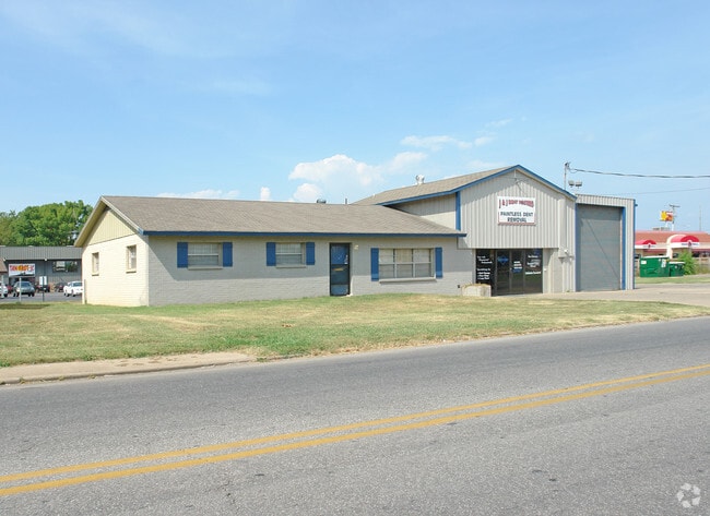
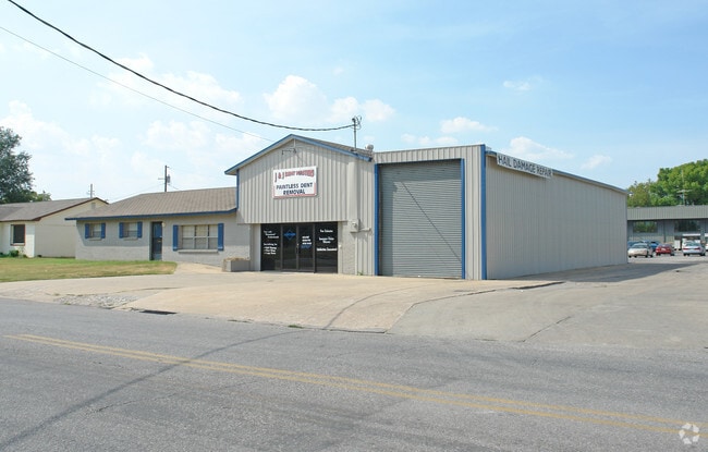
1004 W Maple Ave, Springdale, AR 72764

Property Detail
1004 W Maple Ave
Fayetteville-Springdale-Rogers, AR
PT LOT 34 (PT SE SE 0.301AC) FURTHER DESCRIBED FROM 2014-16996 AS: PART OF THE SOUTHEAST QUARTER OF THE SOUTHEAST QUARTER OF
815-28160-000
Washington
Officebuilding
Arkansas
B and X Area of moderate flood hazard, usually the area between the limits of the 100-year and 500-year floods.
34
2025
0.30 AC
2025
Greater Springdale
010402
Fayetteville/Springdale/Rogers
5,108 SF
NEARBY LISTINGS FOR SALE OR LEASE
DEMOGRAPHICS near 1004 W Maple Ave
1 mile
3 mile
5 mile
2025 Total Population
13,889
77,933
114,722
2030 Population
14,710
83,196
122,965
Pop Growth 2025-2030
+ 5.91%
+ 6.75%
+ 7.19%
Average Age
34
35
36
2025 Total Households
4,411
24,608
38,954
HH Growth 2025-2030
+ 6.01%
+ 6.89%
+ 7.31%
Median Household Inc
$49,032
$62,776
$71,065
Avg Household Size
3.00
3.00
2.80
2025 Avg HH Vehicles
2.00
2.00
2.00
Median Home Value
$182,233
$252,858
$294,052
Median Year Built
1977
1992
1996
Nearby Places
Map Layers
Map Styles
 Street
 Aerial
Layers
 Traffic
 Biking
Places
Listings with unknown addresses are not visible on the map
- Restaurants
- Banks
- Shops
- Fitness
- Groceries
PUBLIC TRANSPORTATION
AIRPORT
Northwest Arkansas Ntl
Drive
Walk
Distance
Northwest Arkansas Ntl
32 min
17.2 mi
SALE & LEASE HISTORY
LISTING DATE
SALE/LEASE

Mar 13, 2019
For Sale
Feb 14, 2017
For Sale
Nearby Properties
Address
Land Use
TOTAL SIZE
Lot Size
Zoning
Address
Land Use
TOTAL SIZE
Lot Size
Zoning
167,116 SF
41.39 AC
I1
Address
Land Use
TOTAL SIZE
Lot Size
Zoning
58,764 SF
1.56 AC
Address
Land Use
TOTAL SIZE
Lot Size
Zoning
403,089 SF
1.93 AC
Address
Land Use
TOTAL SIZE
Lot Size
Zoning
481,800 SF
40 AC
Address
Land Use
TOTAL SIZE
Lot Size
Zoning
437,349 SF
40.29 AC
Address
Land Use
TOTAL SIZE
Lot Size
Zoning
153,718 SF
Address
Land Use
TOTAL SIZE
Lot Size
Zoning
341,266 SF
17.61 AC
Address
Land Use
TOTAL SIZE
Lot Size
Zoning
196,657 SF
18.82 AC
Address
Land Use
TOTAL SIZE
Lot Size
Zoning
117,690 SF
2.38 AC
Address
Land Use
TOTAL SIZE
Lot Size
Zoning
176,204 SF
7.57 AC
Address
Land Use
TOTAL SIZE
Lot Size
Zoning
4,941 SF
10.87 AC
Address
Land Use
TOTAL SIZE
Lot Size
Zoning
193,140 SF
21.31 AC
Address
Land Use
TOTAL SIZE
Lot Size
Zoning
174,333 SF
25 AC
I1I2
Address
Land Use
TOTAL SIZE
Lot Size
Zoning
134,342 SF
14.95 AC
Address
Land Use
TOTAL SIZE
Lot Size
Zoning
156,072 SF
12.43 AC
Address
Land Use
TOTAL SIZE
Lot Size
Zoning
140,755 SF
14.15 AC
Address
Land Use
TOTAL SIZE
Lot Size
Zoning
16,698 SF
1.11 AC
Address
Land Use
TOTAL SIZE
Lot Size
Zoning
229,158 SF
21.23 AC
C2
Address
Land Use
TOTAL SIZE
Lot Size
Zoning
178,140 SF
4.39 AC
Address
Land Use
TOTAL SIZE
Lot Size
Zoning
180,412 SF
13.14 AC
Address
Land Use
TOTAL SIZE
Lot Size
Zoning
167,040 SF
19.98 AC
Address
Land Use
TOTAL SIZE
Lot Size
Zoning
117,196 SF
9.74 AC
Address
Land Use
TOTAL SIZE
Lot Size
Zoning
21,208 SF
1.89 AC
C2
Address
Land Use
TOTAL SIZE
Lot Size
Zoning
224,408 SF
9.80 AC
I1
Address
Land Use
TOTAL SIZE
Lot Size
Zoning
73,436 SF
16.01 AC
I1
Address
Land Use
TOTAL SIZE
Lot Size
Zoning
85,874 SF
2.76 AC
Address
Land Use
TOTAL SIZE
Lot Size
Zoning
16,760 SF
2.96 AC
Address
Land Use
TOTAL SIZE
Lot Size
Zoning
61,431 SF
1.62 AC
C2
Address
Land Use
TOTAL SIZE
Lot Size
Zoning
206,446 SF
17.14 AC
Address
Land Use
TOTAL SIZE
Lot Size
Zoning
111,342 SF
8.35 AC
R2
The World's #1 Commercial Real Estate Marketplace
Connect with us
© 2026 CoStar Group
The information above has been obtained from sources believed reliable. While we do not doubt its accuracy we have not verified it and make no guarantee, warranty or representation about it. It is your responsibility to independently confirm its accuracy and completeness. Any projections, opinions, assumptions, or estimates used are for example only and do not represent the current or future performance of the property. The value of this transaction to you depends on tax and other factors which should be evaluated by your tax, financial, and legal advisors. You and your advisors should conduct a careful, independent investigation of the property to determine to your satisfaction the suitability of the property for your needs.