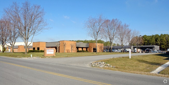
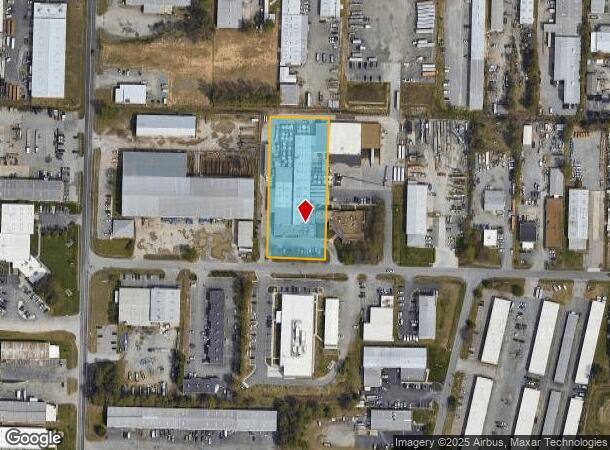
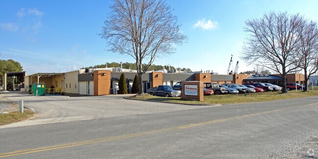
Property Record
10040 Lickinghole Rd, Ashland, VA 23005
NEARBY LISTINGS FOR SALE OR LEASE
Property Detail
10040 Lickinghole Rd
Richmond, VA
Han Ind Air Park
7788-91-2301
V INDUSTRIAL AIR PRK,VII INDUST AIR PARK; LOT:6,3A
Commercialnec
Hanover
X
Virginia
51085C0304C
6
2025
2.07 AC
2025
I-95 N/Mechanicsville
320801
Richmond VA
59,316 SF
DEMOGRAPHICS near 10040 Lickinghole Rd
1 Mile
3 Mile
5 Mile
2024 Total Population
849
23,745
69,930
2029 Population
900
25,114
72,944
Pop Growth 2024-2029
+ 6.01%
+ 5.77%
+ 4.31%
Average Age
40
40
41
2024 Total Households
314
8,911
26,258
HH Growth 2024-2029
+ 6.05%
+ 5.80%
+ 4.31%
Median Household Inc
$120,175
$100,061
$92,506
Avg Household Size
2.70
2.60
2.60
2024 Avg HH Vehicles
2.00
2.00
2.00
Median Home Value
$330,555
$333,471
$322,385
Median Year Built
1992
1996
1992
Nearby Places
Map Layers
Map Styles
 Street
 Aerial
- Restaurants
- Banks
- Shops
- Fitness
- Groceries
PUBLIC TRANSPORTATION
COMMUTER RAIL
Ashland Amtrak (Northeast Regional - Amtrak)
DRIVE
WALK
Distance
Ashland Amtrak (Northeast Regional - Amtrak)
13 min
6.6 mi
Richmond Staples Mill Road Amtrak Station (Carolinian - Amtrak, Northeast Regional - Amtrak, Palmetto - Amtrak, Silver Meteor - Amtrak)
DRIVE
WALK
Distance
Richmond Staples Mill Road Amtrak Station (Carolinian - Amtrak, Northeast Regional - Amtrak, Palmetto - Amtrak, Silver Meteor - Amtrak)
18 min
9.6 mi
AIRPORT
Richmond International
DRIVE
WALK
Distance
Richmond International
31 min
21.2 mi
Freight Ports
Virginia Port Authority - Richmond
DRIVE
WALK
Distance
Virginia Port Authority - Richmond
32 min
20.8 mi
Nearby Properties
Address
Land Use
TOTAL SIZE
Lot Size
Zoning
Address
Land Use
TOTAL SIZE
Lot Size
Zoning
210.61 AC
M-2
Address
Land Use
TOTAL SIZE
Lot Size
Zoning
347,648 SF
24.75 AC
R-5
Address
Land Use
TOTAL SIZE
Lot Size
Zoning
186,034 SF
13.86 AC
B-3C
Address
Land Use
TOTAL SIZE
Lot Size
Zoning
34.69 AC
A-1
Address
Land Use
TOTAL SIZE
Lot Size
Zoning
43.49 AC
M-2
Address
Land Use
TOTAL SIZE
Lot Size
Zoning
59.30 AC
M-2
Address
Land Use
TOTAL SIZE
Lot Size
Zoning
135,874 SF
31.99 AC
MIXE
Address
Land Use
TOTAL SIZE
Lot Size
Zoning
50.20 AC
M-2
Address
Land Use
TOTAL SIZE
Lot Size
Zoning
30.94 AC
M-2
Address
Land Use
TOTAL SIZE
Lot Size
Zoning
2,952 SF
20.87 AC
RM
Address
Land Use
TOTAL SIZE
Lot Size
Zoning
320,540 SF
18.50 AC
M-2
Address
Land Use
TOTAL SIZE
Lot Size
Zoning
216,900 SF
13.41 AC
R-6
Address
Land Use
TOTAL SIZE
Lot Size
Zoning
159,432 SF
14 AC
R-5
Address
Land Use
TOTAL SIZE
Lot Size
Zoning
142,140 SF
10.01 AC
R-5
Address
Land Use
TOTAL SIZE
Lot Size
Zoning
21 AC
M-2
Address
Land Use
TOTAL SIZE
Lot Size
Zoning
293,114 SF
15.56 AC
M-2
Address
Land Use
TOTAL SIZE
Lot Size
Zoning
25.93 AC
M-2
Address
Land Use
TOTAL SIZE
Lot Size
Zoning
24.80 AC
M-2
Address
Land Use
TOTAL SIZE
Lot Size
Zoning
24.17 AC
M-1
Address
Land Use
TOTAL SIZE
Lot Size
Zoning
31.70 AC
M-2
Address
Land Use
TOTAL SIZE
Lot Size
Zoning
128,005 SF
16.91 AC
M-1
Address
Land Use
TOTAL SIZE
Lot Size
Zoning
215,072 SF
16.32 AC
M-2
Address
Land Use
TOTAL SIZE
Lot Size
Zoning
17.80 AC
B-3
Address
Land Use
TOTAL SIZE
Lot Size
Zoning
129,663 SF
14 AC
MIXE
Address
Land Use
TOTAL SIZE
Lot Size
Zoning
89,982 SF
10.20 AC
MIXE
Address
Land Use
TOTAL SIZE
Lot Size
Zoning
195,960 SF
12.60 AC
MIXE
Address
Land Use
TOTAL SIZE
Lot Size
Zoning
16,815 SF
9.16 AC
MIXE
Address
Land Use
TOTAL SIZE
Lot Size
Zoning
146,751 SF
26.71 AC
M-3
Address
Land Use
TOTAL SIZE
Lot Size
Zoning
143.87 AC
M-3
Address
Land Use
TOTAL SIZE
Lot Size
Zoning
15.83 AC
M-2
The World's #1 Commercial Real Estate Marketplace
Connect with us
© 2025 CoStar Group
The information above has been obtained from sources believed reliable. While we do not doubt its accuracy we have not verified it and make no guarantee, warranty or representation about it. It is your responsibility to independently confirm its accuracy and completeness. Any projections, opinions, assumptions, or estimates used are for example only and do not represent the current or future performance of the property. The value of this transaction to you depends on tax and other factors which should be evaluated by your tax, financial, and legal advisors. You and your advisors should conduct a careful, independent investigation of the property to determine to your satisfaction the suitability of the property for your needs.