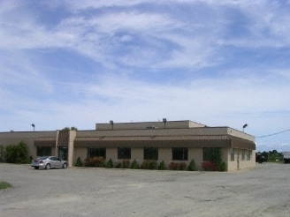
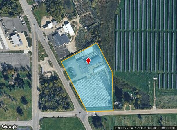
Property Record
10040 N Dort Hwy, Clio, MI 48420


NEARBY LISTINGS FOR SALE OR LEASE
-
-
-
No Photo
-
-
View all Clio listings for sale on LoopNet.com
Property Detail
10040 N Dort Hwy
17-30-300-016
A PARCEL OF LAND BEG N 89 DEG 16 MIN 30 SEC E 492.57 FT FROM SW COR OF SEC TH N 26 DEG 12 MIN W 585 FT TH N 63 DEG 48 MIN E
Commercialnec
Genesee
X
Michigan
26145C0550E
5.34 AC
2024
Flint
2025
Detroit
012503
Flint, MI
20,701 SF
DEMOGRAPHICS near 10040 N Dort Hwy
1 Mile
3 Mile
5 Mile
2024 Total Population
1,635
17,481
39,009
2029 Population
1,648
17,122
38,401
Pop Growth 2024-2029
+ 0.80%
(2.05%)
(1.56%)
Average Age
39
42
41
2024 Total Households
680
7,563
15,990
HH Growth 2024-2029
+ 0.88%
(2.05%)
(1.60%)
Median Household Inc
$37,857
$45,132
$45,876
Avg Household Size
2.30
2.30
2.40
2024 Avg HH Vehicles
1.00
2.00
2.00
Median Home Value
$123,949
$125,736
$122,559
Median Year Built
1974
1969
1967
Nearby Places
Map Layers
Map Styles
 Street
 Aerial
- Restaurants
- Banks
- Shops
- Fitness
- Groceries
PUBLIC TRANSPORTATION
AIRPORT
Bishop International
DRIVE
WALK
Distance
Bishop International
34 min
18.3 mi
MBS International
DRIVE
WALK
Distance
MBS International
60 min
42.1 mi
SALE & LEASE HISTORY
LISTING DATE
SALE/LEASE

Feb 16, 2020
For Sale
Nearby Properties
Address
Land Use
TOTAL SIZE
Lot Size
Zoning
Address
Land Use
TOTAL SIZE
Lot Size
Zoning
2,629 SF
119.59 AC
R-4 MANUF
Address
Land Use
TOTAL SIZE
Lot Size
Zoning
112,217 SF
10 AC
RM
Address
Land Use
TOTAL SIZE
Lot Size
Zoning
131,460 SF
8.10 AC
R-4
Address
Land Use
TOTAL SIZE
Lot Size
Zoning
167,731 SF
17.45 AC
C-3
Address
Land Use
TOTAL SIZE
Lot Size
Zoning
76,074 SF
7.73 AC
RM
Address
Land Use
TOTAL SIZE
Lot Size
Zoning
RU-1-RE
Address
Land Use
TOTAL SIZE
Lot Size
Zoning
RU-1-RE
Address
Land Use
TOTAL SIZE
Lot Size
Zoning
63,888 SF
7 AC
RM
Address
Land Use
TOTAL SIZE
Lot Size
Zoning
59,680 SF
7.63 AC
RM
Address
Land Use
TOTAL SIZE
Lot Size
Zoning
5,242 SF
70.28 AC
MHP
Address
Land Use
TOTAL SIZE
Lot Size
Zoning
94,719 SF
7.55 AC
R-1 SF PUD
Address
Land Use
TOTAL SIZE
Lot Size
Zoning
97,998 SF
11.30 AC
R-1 SF PUD
Address
Land Use
TOTAL SIZE
Lot Size
Zoning
77,994 SF
5.68 AC
RU-2
Address
Land Use
TOTAL SIZE
Lot Size
Zoning
76,051 SF
8.31 AC
C-2 HWY CO
Address
Land Use
TOTAL SIZE
Lot Size
Zoning
Address
Land Use
TOTAL SIZE
Lot Size
Zoning
864 SF
3.18 AC
R-4
Address
Land Use
TOTAL SIZE
Lot Size
Zoning
9,238 SF
84.53 AC
MHP
Address
Land Use
TOTAL SIZE
Lot Size
Zoning
44,350 SF
3.82 AC
GC
Address
Land Use
TOTAL SIZE
Lot Size
Zoning
35.31 AC
MH
Address
Land Use
TOTAL SIZE
Lot Size
Zoning
34,856 SF
2.39 AC
RM
Address
Land Use
TOTAL SIZE
Lot Size
Zoning
54,648 SF
4.68 AC
RU-2
Address
Land Use
TOTAL SIZE
Lot Size
Zoning
39,404 SF
4.47 AC
R-4
Address
Land Use
TOTAL SIZE
Lot Size
Zoning
1.70 AC
Address
Land Use
TOTAL SIZE
Lot Size
Zoning
49,900 SF
10.17 AC
C-2
Address
Land Use
TOTAL SIZE
Lot Size
Zoning
1,912 SF
64.42 AC
MHP
Address
Land Use
TOTAL SIZE
Lot Size
Zoning
12,480 SF
1.54 AC
RMC
Address
Land Use
TOTAL SIZE
Lot Size
Zoning
12,106 SF
1.72 AC
RMC
Address
Land Use
TOTAL SIZE
Lot Size
Zoning
1,430 SF
71.54 AC
R-4 MANUF
Address
Land Use
TOTAL SIZE
Lot Size
Zoning
1,732 SF
0.87 AC
R-1 SF PUD
Address
Land Use
TOTAL SIZE
Lot Size
Zoning
33,200 SF
3.24 AC
I-1 LHGT I
The World's #1 Commercial Real Estate Marketplace
Connect with us
© 2026 CoStar Group
The information above has been obtained from sources believed reliable. While we do not doubt its accuracy we have not verified it and make no guarantee, warranty or representation about it. It is your responsibility to independently confirm its accuracy and completeness. Any projections, opinions, assumptions, or estimates used are for example only and do not represent the current or future performance of the property. The value of this transaction to you depends on tax and other factors which should be evaluated by your tax, financial, and legal advisors. You and your advisors should conduct a careful, independent investigation of the property to determine to your satisfaction the suitability of the property for your needs.