Property Record
10040 Us 301 N, Parrish, FL 34219
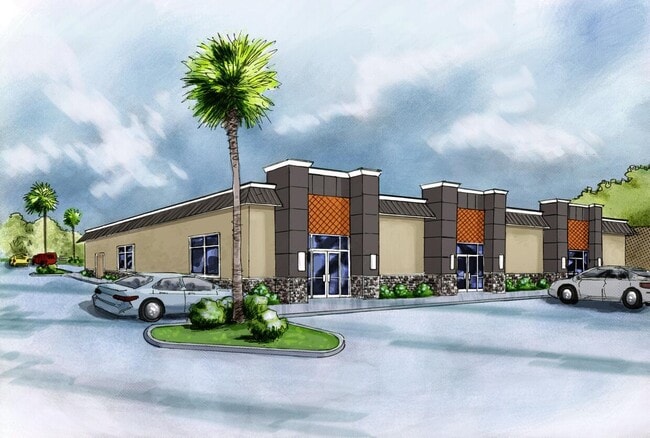
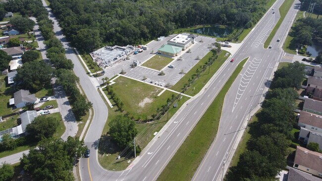
Property Detail
10040 Us 301 N
North Port-Bradenton-Sarasota, FL
LOT 74 BECK ESTATES PI#7353.0000/6
7264-0115-9
MANATEE
Commercialacreage
Florida
PD-MU
74
B and X Area of moderate flood hazard, usually the area between the limits of the 100-year and 500-year floods.
0.12 AC
2023
Manatee
2025
Tampa/St Petersburg
001911
NEARBY LISTINGS FOR SALE OR LEASE
-
-
View all Parrish listings for lease on LoopNet.com
DEMOGRAPHICS near 10040 Us 301 N
1 mile
3 mile
5 mile
2025 Total Population
6,324
42,800
106,320
2030 Population
7,047
48,386
121,433
Pop Growth 2025-2030
+ 11.43%
+ 13.05%
+ 14.21%
Average Age
46
49
45
2025 Total Households
2,508
17,891
42,098
HH Growth 2025-2030
+ 11.52%
+ 13.29%
+ 13.99%
Median Household Inc
$112,606
$93,798
$97,555
Avg Household Size
2.40
2.40
2.50
2025 Avg HH Vehicles
2.00
2.00
2.00
Median Home Value
$422,389
$413,046
$441,547
Median Year Built
2006
2007
2008
Nearby Places
Map Layers
Map Styles
 Street
 Aerial
Transit
 Traffic
 Biking
Places
Listings with unknown addresses are not visible on the map
- Restaurants
- Banks
- Shops
- Fitness
- Groceries
PUBLIC TRANSPORTATION
AIRPORT
Sarasota/Bradenton International
Drive
Walk
Distance
Sarasota/Bradenton International
31 min
16.9 mi
St Pete-Clearwater International
Drive
Walk
Distance
St Pete-Clearwater International
57 min
40.2 mi
Tampa International
Drive
Walk
Distance
Tampa International
64 min
48.9 mi
Freight Ports
Port Manatee
Drive
Walk
Distance
Port Manatee
22 min
12.9 mi
SALE & LEASE HISTORY
LISTING DATE
SALE/LEASE

Jun 13, 2024
For Lease
Jun 12, 2024
For Lease
Nearby Properties
Address
Land Use
TOTAL SIZE
Lot Size
Zoning
Address
Land Use
TOTAL SIZE
Lot Size
Zoning
359,241 SF
27.68 AC
PD-MU
Address
Land Use
TOTAL SIZE
Lot Size
Zoning
137.34 AC
Address
Land Use
TOTAL SIZE
Lot Size
Zoning
313,422 SF
47.93 AC
PD-C
Address
Land Use
TOTAL SIZE
Lot Size
Zoning
96.46 AC
Address
Land Use
TOTAL SIZE
Lot Size
Zoning
456,317 SF
46.75 AC
PD-R
Address
Land Use
TOTAL SIZE
Lot Size
Zoning
312,546 SF
39.60 AC
A-1 SUBURB
Address
Land Use
TOTAL SIZE
Lot Size
Zoning
191,100 SF
30.35 AC
PD-C
Address
Land Use
TOTAL SIZE
Lot Size
Zoning
136.89 AC
Address
Land Use
TOTAL SIZE
Lot Size
Zoning
50.25 AC
Address
Land Use
TOTAL SIZE
Lot Size
Zoning
64,800 SF
8.19 AC
Address
Land Use
TOTAL SIZE
Lot Size
Zoning
61,770 SF
79.85 AC
A,A-1
Address
Land Use
TOTAL SIZE
Lot Size
Zoning
66,063 SF
9.24 AC
PD-C
Address
Land Use
TOTAL SIZE
Lot Size
Zoning
158.58 AC
Address
Land Use
TOTAL SIZE
Lot Size
Zoning
43,464 SF
14.47 AC
VIL VILLAG
Address
Land Use
TOTAL SIZE
Lot Size
Zoning
190.90 AC
PD-R
Address
Land Use
TOTAL SIZE
Lot Size
Zoning
59,222 SF
4.49 AC
PD-C
Address
Land Use
TOTAL SIZE
Lot Size
Zoning
43.81 AC
Address
Land Use
TOTAL SIZE
Lot Size
Zoning
56,442 SF
6.18 AC
GC GENERA
Address
Land Use
TOTAL SIZE
Lot Size
Zoning
61,721 SF
5.50 AC
PD-C
Address
Land Use
TOTAL SIZE
Lot Size
Zoning
36,002 SF
4.41 AC
PD-C
Address
Land Use
TOTAL SIZE
Lot Size
Zoning
5,744 SF
12.60 AC
RSMH-6
Address
Land Use
TOTAL SIZE
Lot Size
Zoning
7.86 AC
PD-MU
Address
Land Use
TOTAL SIZE
Lot Size
Zoning
32,860 SF
4.05 AC
PD-O
Address
Land Use
TOTAL SIZE
Lot Size
Zoning
28,413 SF
5.40 AC
RSMH-6
Address
Land Use
TOTAL SIZE
Lot Size
Zoning
1,596 SF
106.35 AC
PD-R
Address
Land Use
TOTAL SIZE
Lot Size
Zoning
53,851 SF
6.32 AC
Address
Land Use
TOTAL SIZE
Lot Size
Zoning
30,101 SF
13.44 AC
PD-C
Address
Land Use
TOTAL SIZE
Lot Size
Zoning
41,168 SF
3.21 AC
PD-C
Address
Land Use
TOTAL SIZE
Lot Size
Zoning
22,855 SF
23.30 AC
PD-R
Address
Land Use
TOTAL SIZE
Lot Size
Zoning
23,742 SF
5.21 AC
A-1 SUBURB
The World's #1 Commercial Real Estate Marketplace
Connect with us
© 2026 CoStar Group
The information above has been obtained from sources believed reliable. While we do not doubt its accuracy we have not verified it and make no guarantee, warranty or representation about it. It is your responsibility to independently confirm its accuracy and completeness. Any projections, opinions, assumptions, or estimates used are for example only and do not represent the current or future performance of the property. The value of this transaction to you depends on tax and other factors which should be evaluated by your tax, financial, and legal advisors. You and your advisors should conduct a careful, independent investigation of the property to determine to your satisfaction the suitability of the property for your needs.