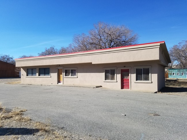
Property Record
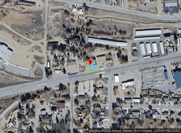
10040 Us Highway 50, Poncha Springs, CO 81242

NEARBY LISTINGS FOR SALE OR LEASE
-
-
View all Poncha Springs listings for sale on LoopNet.com
Property Detail
10040 Us Highway 50
Storebuilding
TRACT IN SE4NW4 10-49-8 REC 475340
X
Chaffee
08015C0589D
Colorado
2024
0.27 AC
2024
Colorado Southwest Area
000300
Other Market Areas
1,206 SF
R380510200113
DEMOGRAPHICS near 10040 Us Highway 50
1 Mile
3 Mile
5 Mile
2024 Total Population
868
1,859
9,658
2029 Population
938
2,019
10,588
Pop Growth 2024-2029
+ 8.06%
+ 8.61%
+ 9.63%
Average Age
46
46
46
2024 Total Households
404
859
4,542
HH Growth 2024-2029
+ 8.42%
+ 9.08%
+ 10.08%
Median Household Inc
$76,958
$77,083
$66,969
Avg Household Size
2.10
2.10
2.10
2024 Avg HH Vehicles
2.00
2.00
2.00
Median Home Value
$685,897
$655,234
$516,876
Median Year Built
1997
1997
1992
Nearby Places
Map Layers
Map Styles
 Street
 Aerial
- Restaurants
- Banks
- Shops
- Fitness
- Groceries
SALE & LEASE HISTORY
LISTING DATE
SALE/LEASE

Mar 30, 2017
For Sale
Jun 28, 2021
For Sale
Aug 07, 2019
For Sale
Nearby Properties
Address
Land Use
TOTAL SIZE
Lot Size
Zoning
Address
Land Use
TOTAL SIZE
Lot Size
Zoning
109,252 SF
14.06 AC
Address
Land Use
TOTAL SIZE
Lot Size
Zoning
32,100 SF
3.73 AC
Address
Land Use
TOTAL SIZE
Lot Size
Zoning
11,700 SF
20 AC
Address
Land Use
TOTAL SIZE
Lot Size
Zoning
11,912 SF
4.19 AC
Address
Land Use
TOTAL SIZE
Lot Size
Zoning
25,795 SF
2.96 AC
Address
Land Use
TOTAL SIZE
Lot Size
Zoning
2,460 SF
70.58 AC
Address
Land Use
TOTAL SIZE
Lot Size
Zoning
2,800 SF
4.15 AC
Address
Land Use
TOTAL SIZE
Lot Size
Zoning
120 SF
59.52 AC
Address
Land Use
TOTAL SIZE
Lot Size
Zoning
1,515 SF
172.40 AC
Address
Land Use
TOTAL SIZE
Lot Size
Zoning
5,300 SF
10.36 AC
Address
Land Use
TOTAL SIZE
Lot Size
Zoning
8,000 SF
0.56 AC
Address
Land Use
TOTAL SIZE
Lot Size
Zoning
35,500 SF
6.47 AC
Address
Land Use
TOTAL SIZE
Lot Size
Zoning
1,200 SF
1.74 AC
Address
Land Use
TOTAL SIZE
Lot Size
Zoning
6,400 SF
1.91 AC
Address
Land Use
TOTAL SIZE
Lot Size
Zoning
10,572 SF
2.36 AC
Address
Land Use
TOTAL SIZE
Lot Size
Zoning
9,920 SF
16.02 AC
Address
Land Use
TOTAL SIZE
Lot Size
Zoning
1,480 SF
7.84 AC
Address
Land Use
TOTAL SIZE
Lot Size
Zoning
13,000 SF
3.27 AC
Address
Land Use
TOTAL SIZE
Lot Size
Zoning
11,200 SF
2.07 AC
Address
Land Use
TOTAL SIZE
Lot Size
Zoning
6,000 SF
1.02 AC
Address
Land Use
TOTAL SIZE
Lot Size
Zoning
2,880 SF
3.39 AC
Address
Land Use
TOTAL SIZE
Lot Size
Zoning
1,560 SF
3.35 AC
Address
Land Use
TOTAL SIZE
Lot Size
Zoning
24,000 SF
3.36 AC
Address
Land Use
TOTAL SIZE
Lot Size
Zoning
8,400 SF
2.60 AC
Address
Land Use
TOTAL SIZE
Lot Size
Zoning
1,573 SF
0.95 AC
Address
Land Use
TOTAL SIZE
Lot Size
Zoning
2,100 SF
185 AC
Address
Land Use
TOTAL SIZE
Lot Size
Zoning
3,888 SF
1.42 AC
Address
Land Use
TOTAL SIZE
Lot Size
Zoning
1,107 SF
0.89 AC
Address
Land Use
TOTAL SIZE
Lot Size
Zoning
2,440 SF
1.15 AC
Address
Land Use
TOTAL SIZE
Lot Size
Zoning
2,277 SF
1.43 AC
The World's #1 Commercial Real Estate Marketplace
Connect with us
© 2025 CoStar Group
The information above has been obtained from sources believed reliable. While we do not doubt its accuracy we have not verified it and make no guarantee, warranty or representation about it. It is your responsibility to independently confirm its accuracy and completeness. Any projections, opinions, assumptions, or estimates used are for example only and do not represent the current or future performance of the property. The value of this transaction to you depends on tax and other factors which should be evaluated by your tax, financial, and legal advisors. You and your advisors should conduct a careful, independent investigation of the property to determine to your satisfaction the suitability of the property for your needs.