Property Record
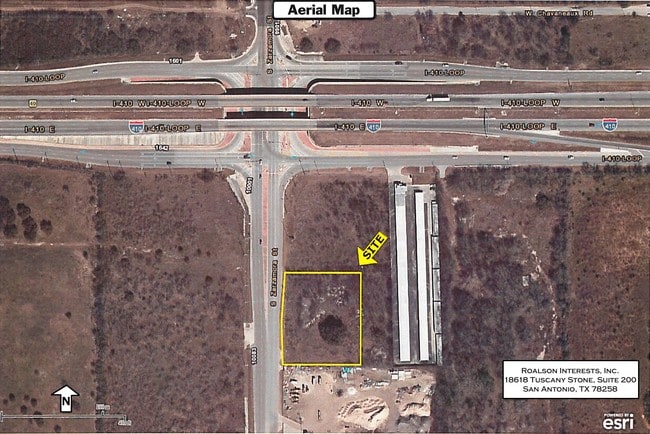
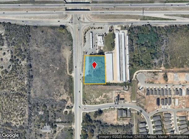
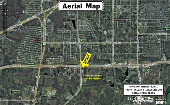
10042 S Zarzamora St, San Antonio, TX 78224
NEARBY LISTINGS FOR SALE OR LEASE
Property Detail
10042 S Zarzamora St
San Antonio
Ncb 18088 (Mcdonalds #42-3379)
San Antonio-New Braunfels, TX
NCB 18088 (MCDONALDS #42-3379) BLK 1 LOT 2 2024- NEW PER PLAT 20003/1019 FILED 11-17-2023. CR-61648 JLF/GIS/4-20-2024
18088-001-0020
Bexar
Restaurantdrivein
Texas
2024
23
2025
1.66 AC
152000
South
4,674 SF
DEMOGRAPHICS near 10042 S Zarzamora St
1 Mile
3 Mile
5 Mile
2024 Total Population
4,983
59,258
136,072
2029 Population
5,333
63,165
144,884
Pop Growth 2024-2029
+ 7.02%
+ 6.59%
+ 6.48%
Average Age
35
36
36
2024 Total Households
1,405
18,203
43,278
HH Growth 2024-2029
+ 7.26%
+ 6.72%
+ 6.62%
Median Household Inc
$53,443
$48,698
$45,763
Avg Household Size
3.30
3.10
3.00
2024 Avg HH Vehicles
2.00
2.00
2.00
Median Home Value
$170,226
$131,967
$122,213
Median Year Built
1987
1977
1970
Nearby Places
Map Layers
Map Styles
 Street
 Aerial
- Restaurants
- Banks
- Shops
- Fitness
- Groceries
PUBLIC TRANSPORTATION
COMMUTER RAIL
San Antonio Amtrak Station (Sunset Limited - Amtrak, Texas Eagle - Amtrak)
DRIVE
WALK
Distance
San Antonio Amtrak Station (Sunset Limited - Amtrak, Texas Eagle - Amtrak)
16 min
9.7 mi
AIRPORT
San Antonio International
DRIVE
WALK
Distance
San Antonio International
24 min
16.1 mi
Freight Ports
Port of Corpus Christi
DRIVE
WALK
Distance
Port of Corpus Christi
145 min
141.9 mi
SALE & LEASE HISTORY
LISTING DATE
SALE/LEASE

Sep 24, 2016
For Sale
Nearby Properties
Address
Land Use
TOTAL SIZE
Lot Size
Zoning
Address
Land Use
TOTAL SIZE
Lot Size
Zoning
548,048 SF
27.53 AC
Address
Land Use
TOTAL SIZE
Lot Size
Zoning
324,153 SF
17.31 AC
Address
Land Use
TOTAL SIZE
Lot Size
Zoning
504,337 SF
45.55 AC
Address
Land Use
TOTAL SIZE
Lot Size
Zoning
447,169 SF
46.74 AC
Address
Land Use
TOTAL SIZE
Lot Size
Zoning
71,607 SF
10.46 AC
Address
Land Use
TOTAL SIZE
Lot Size
Zoning
218,003 SF
12.33 AC
Address
Land Use
TOTAL SIZE
Lot Size
Zoning
11,553 SF
67.15 AC
Address
Land Use
TOTAL SIZE
Lot Size
Zoning
80,936 SF
13.48 AC
Address
Land Use
TOTAL SIZE
Lot Size
Zoning
45,363 SF
4.29 AC
Address
Land Use
TOTAL SIZE
Lot Size
Zoning
143,067 SF
11.69 AC
Address
Land Use
TOTAL SIZE
Lot Size
Zoning
56,875 SF
10.04 AC
Address
Land Use
TOTAL SIZE
Lot Size
Zoning
526.61 AC
Address
Land Use
TOTAL SIZE
Lot Size
Zoning
188,948 SF
20.59 AC
Address
Land Use
TOTAL SIZE
Lot Size
Zoning
166,270 SF
13.95 AC
Address
Land Use
TOTAL SIZE
Lot Size
Zoning
38,671 SF
5.20 AC
Address
Land Use
TOTAL SIZE
Lot Size
Zoning
141,606 SF
13.74 AC
Address
Land Use
TOTAL SIZE
Lot Size
Zoning
67,184 SF
60.16 AC
Address
Land Use
TOTAL SIZE
Lot Size
Zoning
590.88 AC
Address
Land Use
TOTAL SIZE
Lot Size
Zoning
47.74 AC
Address
Land Use
TOTAL SIZE
Lot Size
Zoning
73,178 SF
23.11 AC
Address
Land Use
TOTAL SIZE
Lot Size
Zoning
116,964 SF
15.07 AC
Address
Land Use
TOTAL SIZE
Lot Size
Zoning
34,344 SF
9.79 AC
Address
Land Use
TOTAL SIZE
Lot Size
Zoning
72,868 SF
14.79 AC
Address
Land Use
TOTAL SIZE
Lot Size
Zoning
51,960 SF
8 AC
Address
Land Use
TOTAL SIZE
Lot Size
Zoning
86,352 SF
5.05 AC
Address
Land Use
TOTAL SIZE
Lot Size
Zoning
137,586 SF
13.50 AC
Address
Land Use
TOTAL SIZE
Lot Size
Zoning
262,013 SF
13.41 AC
Address
Land Use
TOTAL SIZE
Lot Size
Zoning
168.41 AC
Address
Land Use
TOTAL SIZE
Lot Size
Zoning
153,762 SF
8.34 AC
Address
Land Use
TOTAL SIZE
Lot Size
Zoning
101,660 SF
4.57 AC
The World's #1 Commercial Real Estate Marketplace
Connect with us
© 2025 CoStar Group
The information above has been obtained from sources believed reliable. While we do not doubt its accuracy we have not verified it and make no guarantee, warranty or representation about it. It is your responsibility to independently confirm its accuracy and completeness. Any projections, opinions, assumptions, or estimates used are for example only and do not represent the current or future performance of the property. The value of this transaction to you depends on tax and other factors which should be evaluated by your tax, financial, and legal advisors. You and your advisors should conduct a careful, independent investigation of the property to determine to your satisfaction the suitability of the property for your needs.