Property Record
1005 2Nd St, Verdi, NV 89439
NEARBY LISTINGS FOR SALE OR LEASE
-
-
View all Verdi listings for sale on LoopNet.com
Property Detail
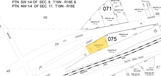
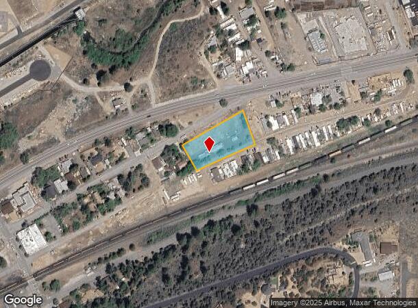
1005 2Nd St
038-075-35
_Unspecified
Multifamilydwelling
FRAC N2 NE4 NW4 SEC 17 TWP 19N RGE 18E
X
Washoe
32031C3013G
Nevada
2025
0.95 AC
2026
S Outlying Washoe County
002302
Reno/Sparks
1,553 SF
Reno, NV
DEMOGRAPHICS near 1005 2Nd St
1 Mile
3 Mile
5 Mile
2024 Total Population
1,747
7,514
17,786
2029 Population
1,838
7,953
18,742
Pop Growth 2024-2029
+ 5.21%
+ 5.84%
+ 5.38%
Average Age
46
52
46
2024 Total Households
746
3,374
7,517
HH Growth 2024-2029
+ 4.96%
+ 6.02%
+ 5.55%
Median Household Inc
$74,999
$113,030
$112,366
Avg Household Size
2.30
2.20
2.30
2024 Avg HH Vehicles
2.00
2.00
2.00
Median Home Value
$709,437
$671,451
$640,272
Median Year Built
1993
2006
2004
Nearby Places
Map Layers
Map Styles
 Street
 Aerial
- Restaurants
- Banks
- Shops
- Fitness
- Groceries
PUBLIC TRANSPORTATION
AIRPORT
Reno/Tahoe International
DRIVE
WALK
Distance
Reno/Tahoe International
22 min
14.9 mi
Nearby Properties
Address
Land Use
TOTAL SIZE
Lot Size
Zoning
Address
Land Use
TOTAL SIZE
Lot Size
Zoning
252,869 SF
10.77 AC
MF14 97% /
Address
Land Use
TOTAL SIZE
Lot Size
Zoning
359,209 SF
8.83 AC
HC
Address
Land Use
TOTAL SIZE
Lot Size
Zoning
257,834 SF
14.94 AC
MS
Address
Land Use
TOTAL SIZE
Lot Size
Zoning
127,616 SF
20.80 AC
AC
Address
Land Use
TOTAL SIZE
Lot Size
Zoning
221,000 SF
13.78 AC
IC
Address
Land Use
TOTAL SIZE
Lot Size
Zoning
170,090 SF
11.60 AC
MS 91% / S
Address
Land Use
TOTAL SIZE
Lot Size
Zoning
206,891 SF
13.81 AC
IC
Address
Land Use
TOTAL SIZE
Lot Size
Zoning
182,000 SF
13.56 AC
IC
Address
Land Use
TOTAL SIZE
Lot Size
Zoning
1,200 SF
34.91 AC
MS
Address
Land Use
TOTAL SIZE
Lot Size
Zoning
182,656 SF
10.50 AC
IC
Address
Land Use
TOTAL SIZE
Lot Size
Zoning
480.53 AC
PGOS 45% /
Address
Land Use
TOTAL SIZE
Lot Size
Zoning
440 AC
SF6 15% /
Address
Land Use
TOTAL SIZE
Lot Size
Zoning
115,848 SF
9.61 AC
PD
Address
Land Use
TOTAL SIZE
Lot Size
Zoning
14,540 SF
8.90 AC
HC
Address
Land Use
TOTAL SIZE
Lot Size
Zoning
133,701 SF
21.38 AC
I
Address
Land Use
TOTAL SIZE
Lot Size
Zoning
23,438 SF
11.25 AC
MS
Address
Land Use
TOTAL SIZE
Lot Size
Zoning
2,438 SF
1.27 AC
OS 28%/PF
Address
Land Use
TOTAL SIZE
Lot Size
Zoning
22,703 SF
5.43 AC
GC
Address
Land Use
TOTAL SIZE
Lot Size
Zoning
242.86 AC
SF9 12% /
Address
Land Use
TOTAL SIZE
Lot Size
Zoning
88,560 SF
4 AC
I
Address
Land Use
TOTAL SIZE
Lot Size
Zoning
643.88 AC
SF6 13% /
Address
Land Use
TOTAL SIZE
Lot Size
Zoning
678 SF
76.94 AC
SF6 34%/ S
Address
Land Use
TOTAL SIZE
Lot Size
Zoning
35.39 AC
GF
Address
Land Use
TOTAL SIZE
Lot Size
Zoning
24,752 SF
1.37 AC
SPD
Address
Land Use
TOTAL SIZE
Lot Size
Zoning
49.20 AC
RR15
Address
Land Use
TOTAL SIZE
Lot Size
Zoning
61.14 AC
OS 29% / A
Address
Land Use
TOTAL SIZE
Lot Size
Zoning
16,905 SF
4.33 AC
I
Address
Land Use
TOTAL SIZE
Lot Size
Zoning
42,026 SF
5.79 AC
PD
Address
Land Use
TOTAL SIZE
Lot Size
Zoning
112.42 AC
SF9 52% /
Address
Land Use
TOTAL SIZE
Lot Size
Zoning
6,116 SF
1.22 AC
PD
The World's #1 Commercial Real Estate Marketplace
Connect with us
© 2026 CoStar Group
The information above has been obtained from sources believed reliable. While we do not doubt its accuracy we have not verified it and make no guarantee, warranty or representation about it. It is your responsibility to independently confirm its accuracy and completeness. Any projections, opinions, assumptions, or estimates used are for example only and do not represent the current or future performance of the property. The value of this transaction to you depends on tax and other factors which should be evaluated by your tax, financial, and legal advisors. You and your advisors should conduct a careful, independent investigation of the property to determine to your satisfaction the suitability of the property for your needs.