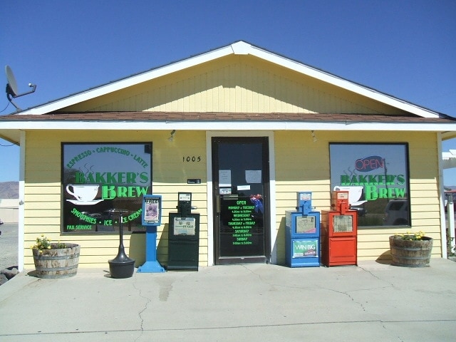
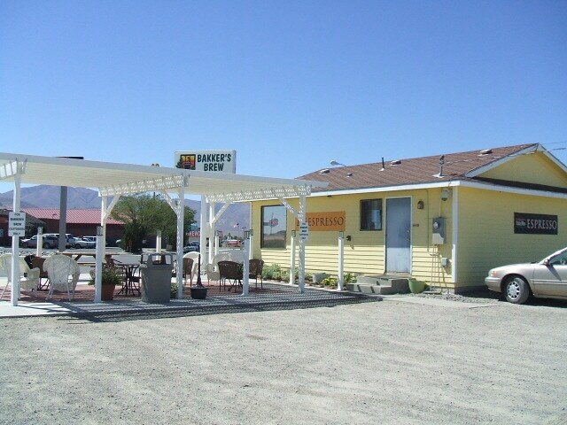
Property Record
1005 Broyles Ranch Rd, Battle Mountain, NV 89820

Property Detail
1005 Broyles Ranch Rd
002-200-22
PARCEL 7, LANDER COUNTY BOARD OF COMMISSIONERS LAND EXCHANGE & GRANT OF RIGHT-OF-WAY, RECORD OF SURVEY MAP, DOC# 104666, RECORDED 02/02/1981, BOOK 101, PAGE 178: ALL THAT CERTAIN REAL PROPERTY SITUATE IN THE COUNTY OF LANDER, STATE OF NEVADA, MORE PA
Commercialnec
Lander
C1
Nevada
B and X Area of moderate flood hazard, usually the area between the limits of the 100-year and 500-year floods.
7
2025
0.35 AC
2025
Carson City/Nevada Area
000301
Other Market Areas
912 SF
NEARBY LISTINGS FOR SALE OR LEASE
-
-
View all Battle Mountain listings for sale on LoopNet.com
DEMOGRAPHICS near 1005 Broyles Ranch Rd
1 mile
3 mile
5 mile
2025 Total Population
3,331
4,094
4,406
2030 Population
3,356
4,119
4,431
Pop Growth 2025-2030
+ 0.75%
+ 0.61%
+ 0.57%
Average Age
39
39
39
2025 Total Households
1,336
1,630
1,756
HH Growth 2025-2030
+ 0.82%
+ 0.67%
+ 0.63%
Median Household Inc
$68,630
$76,896
$78,296
Avg Household Size
2.50
2.50
2.50
2025 Avg HH Vehicles
2.00
2.00
2.00
Median Home Value
$210,371
$213,075
$212,832
Median Year Built
1985
1986
1987
Nearby Places
Map Layers
Map Styles
 Street
 Aerial
Layers
 Traffic
 Biking
Places
Listings with unknown addresses are not visible on the map
- Restaurants
- Banks
- Shops
- Fitness
- Groceries
Nearby Properties
Address
Land Use
TOTAL SIZE
Lot Size
Zoning
Address
Land Use
TOTAL SIZE
Lot Size
Zoning
Address
Land Use
TOTAL SIZE
Lot Size
Zoning
6,264 SF
3.03 AC
R4
Address
Land Use
TOTAL SIZE
Lot Size
Zoning
6,034 SF
10.21 AC
C2
Address
Land Use
TOTAL SIZE
Lot Size
Zoning
22.95 AC
M
Address
Land Use
TOTAL SIZE
Lot Size
Zoning
39,850 SF
10.87 AC
C2
Address
Land Use
TOTAL SIZE
Lot Size
Zoning
4,630 SF
2.43 AC
C2
Address
Land Use
TOTAL SIZE
Lot Size
Zoning
27,042 SF
1.57 AC
C1
Address
Land Use
TOTAL SIZE
Lot Size
Zoning
29,418 SF
1.30 AC
C1
Address
Land Use
TOTAL SIZE
Lot Size
Zoning
7,888 SF
2.87 AC
C2
Address
Land Use
TOTAL SIZE
Lot Size
Zoning
A3;FARM/FO
Address
Land Use
TOTAL SIZE
Lot Size
Zoning
9,408 SF
172.51 AC
GP
Address
Land Use
TOTAL SIZE
Lot Size
Zoning
13,650 SF
1.06 AC
C1
Address
Land Use
TOTAL SIZE
Lot Size
Zoning
Address
Land Use
TOTAL SIZE
Lot Size
Zoning
24,544 SF
1.91 AC
C2
Address
Land Use
TOTAL SIZE
Lot Size
Zoning
395 SF
28,995.22 AC
A3
Address
Land Use
TOTAL SIZE
Lot Size
Zoning
41,541 SF
2.59 AC
C1
Address
Land Use
TOTAL SIZE
Lot Size
Zoning
4,968 SF
13.17 AC
C2
Address
Land Use
TOTAL SIZE
Lot Size
Zoning
4,248 SF
1.70 AC
R4
Address
Land Use
TOTAL SIZE
Lot Size
Zoning
6,175 SF
2.06 AC
GP
Address
Land Use
TOTAL SIZE
Lot Size
Zoning
5,700 SF
2.88 AC
R4
Address
Land Use
TOTAL SIZE
Lot Size
Zoning
1,496 SF
0.42 AC
R4
Address
Land Use
TOTAL SIZE
Lot Size
Zoning
1,496 SF
0.42 AC
R4
Address
Land Use
TOTAL SIZE
Lot Size
Zoning
4,536 SF
0.91 AC
C1
Address
Land Use
TOTAL SIZE
Lot Size
Zoning
420 SF
1.70 AC
R4
Address
Land Use
TOTAL SIZE
Lot Size
Zoning
963 SF
3,600.93 AC
A3
Address
Land Use
TOTAL SIZE
Lot Size
Zoning
21,827 SF
1.15 AC
C2
Address
Land Use
TOTAL SIZE
Lot Size
Zoning
11,400 SF
3.87 AC
R1
Address
Land Use
TOTAL SIZE
Lot Size
Zoning
9,080 SF
0.84 AC
C1
Address
Land Use
TOTAL SIZE
Lot Size
Zoning
27,060 SF
2.30 AC
C1
Address
Land Use
TOTAL SIZE
Lot Size
Zoning
4,174 SF
0.49 AC
C1
The World's #1 Commercial Real Estate Marketplace
Connect with us
© 2026 CoStar Group
The information above has been obtained from sources believed reliable. While we do not doubt its accuracy we have not verified it and make no guarantee, warranty or representation about it. It is your responsibility to independently confirm its accuracy and completeness. Any projections, opinions, assumptions, or estimates used are for example only and do not represent the current or future performance of the property. The value of this transaction to you depends on tax and other factors which should be evaluated by your tax, financial, and legal advisors. You and your advisors should conduct a careful, independent investigation of the property to determine to your satisfaction the suitability of the property for your needs.