Property Record
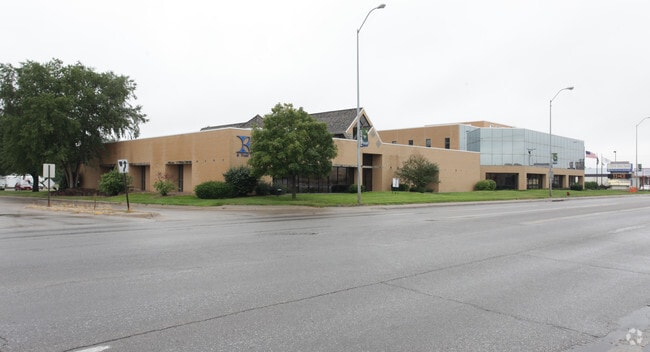
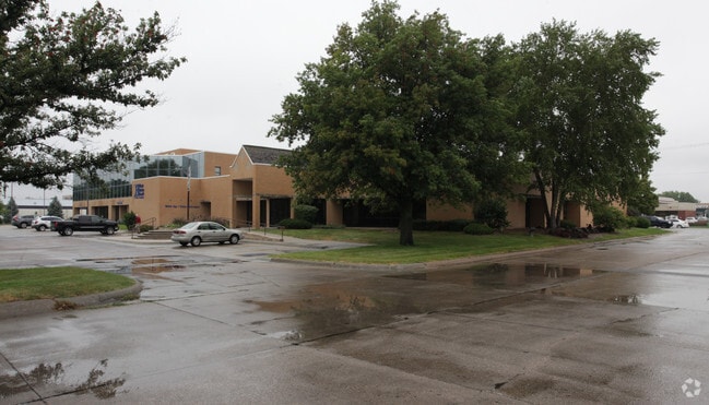
1005 E 23Rd St, Fremont, NE 68025

Save to a Folder
{{folder.Name}}
{{folder.ListingIds.length}} Properties
{{folder.ListingIds.length}} Property
Create a New Folder
Property Detail
1005 E 23Rd St
270040033
LEWIS ADD LOTS 4,5 & 6; MAP NUMBER: 2391-14-1-91670-000-0000
Financialbuilding
Dodge
COMMERCIAL
Nebraska
C and X Area of minimal flood hazard, usually depicted on FIRMs as above the 500-year flood level.
4-6
2025
2.01 AC
2025
Nebraska Area
964000
Other Market Areas
45,228 SF
Fremont, NE
NEARBY LISTINGS FOR SALE OR LEASE
-
-
View all Fremont listings for sale on LoopNet.com
DEMOGRAPHICS near 1005 E 23Rd St
1 mile
3 mile
5 mile
2025 Total Population
9,227
28,679
32,053
2030 Population
9,447
29,266
32,938
Pop Growth 2025-2030
+ 2.38%
+ 2.05%
+ 2.76%
Average Age
41
40
40
2025 Total Households
3,913
11,443
12,774
HH Growth 2025-2030
+ 2.63%
+ 2.12%
+ 2.84%
Median Household Inc
$59,575
$71,041
$74,455
Avg Household Size
2.30
2.40
2.40
2025 Avg HH Vehicles
2.00
2.00
2.00
Median Home Value
$215,206
$219,816
$234,288
Median Year Built
1963
1966
1969
Nearby Places
Map Layers
Map Styles
 Street
 Aerial
Layers
 Traffic
 Biking
Places
Listings with unknown addresses are not visible on the map
- Restaurants
- Banks
- Shops
- Fitness
- Groceries
PUBLIC TRANSPORTATION
AIRPORT
Eppley Airfield
Drive
Walk
Distance
Eppley Airfield
58 min
39.1 mi
Nearby Properties
Address
Land Use
TOTAL SIZE
Lot Size
Zoning
Address
Land Use
TOTAL SIZE
Lot Size
Zoning
3,200 SF
139.47 AC
INDUSTRIAL
Address
Land Use
TOTAL SIZE
Lot Size
Zoning
7,385 SF
20.27 AC
INDUSTRIAL
Address
Land Use
TOTAL SIZE
Lot Size
Zoning
97,514 SF
99.68 AC
INDUSTRIAL
Address
Land Use
TOTAL SIZE
Lot Size
Zoning
28,281 SF
14.60 AC
COMMERCIAL
Address
Land Use
TOTAL SIZE
Lot Size
Zoning
7,504 SF
25.27 AC
INDUSTRIAL
Address
Land Use
TOTAL SIZE
Lot Size
Zoning
33,392 SF
5.57 AC
SINGLE-FAM
Address
Land Use
TOTAL SIZE
Lot Size
Zoning
162,301 SF
18.06 AC
COMMERCIAL
Address
Land Use
TOTAL SIZE
Lot Size
Zoning
200,088 SF
23.04 AC
COMMERCIAL
Address
Land Use
TOTAL SIZE
Lot Size
Zoning
52,993 SF
4 AC
COMMERCIAL
Address
Land Use
TOTAL SIZE
Lot Size
Zoning
4,120 SF
9.44 AC
MULTI-FAMI
Address
Land Use
TOTAL SIZE
Lot Size
Zoning
55,742 SF
6.40 AC
COMMERCIAL
Address
Land Use
TOTAL SIZE
Lot Size
Zoning
59,307 SF
1.99 AC
COMMERCIAL
Address
Land Use
TOTAL SIZE
Lot Size
Zoning
36,061 SF
8.89 AC
COMMERCIAL
Address
Land Use
TOTAL SIZE
Lot Size
Zoning
21,384 SF
15 AC
INDUSTRIAL
Address
Land Use
TOTAL SIZE
Lot Size
Zoning
20,314 SF
44.71 AC
INDUSTRIAL
Address
Land Use
TOTAL SIZE
Lot Size
Zoning
99,964 SF
7.47 AC
INDUSTRIAL
Address
Land Use
TOTAL SIZE
Lot Size
Zoning
3,000 SF
4.37 AC
INDUSTRIAL
Address
Land Use
TOTAL SIZE
Lot Size
Zoning
65,589 SF
5.76 AC
COMMERCIAL
Address
Land Use
TOTAL SIZE
Lot Size
Zoning
60,000 SF
11.02 AC
INDUSTRIAL
Address
Land Use
TOTAL SIZE
Lot Size
Zoning
67,947 SF
10.67 AC
INDUSTRIAL
Address
Land Use
TOTAL SIZE
Lot Size
Zoning
4,952 SF
4.64 AC
MULTI-FAMI
Address
Land Use
TOTAL SIZE
Lot Size
Zoning
54,558 SF
2.27 AC
MULTI-FAMI
Address
Land Use
TOTAL SIZE
Lot Size
Zoning
43,560 SF
1.75 AC
COMMERCIAL
Address
Land Use
TOTAL SIZE
Lot Size
Zoning
65,171 SF
16.10 AC
INDUSTRIAL
Address
Land Use
TOTAL SIZE
Lot Size
Zoning
3,360 SF
4.99 AC
INDUSTRIAL
Address
Land Use
TOTAL SIZE
Lot Size
Zoning
18,346 SF
2.94 AC
COMMERCIAL
Address
Land Use
TOTAL SIZE
Lot Size
Zoning
22,928 SF
2.82 AC
INDUSTRIAL
Address
Land Use
TOTAL SIZE
Lot Size
Zoning
49,481 SF
4.86 AC
COMMERCIAL
The World's #1 Commercial Real Estate Marketplace
Connect with us
© 2026 CoStar Group
The information above has been obtained from sources believed reliable. While we do not doubt its accuracy we have not verified it and make no guarantee, warranty or representation about it. It is your responsibility to independently confirm its accuracy and completeness. Any projections, opinions, assumptions, or estimates used are for example only and do not represent the current or future performance of the property. The value of this transaction to you depends on tax and other factors which should be evaluated by your tax, financial, and legal advisors. You and your advisors should conduct a careful, independent investigation of the property to determine to your satisfaction the suitability of the property for your needs.