Property Record
1005 E Ohio Ave, Rittman, OH 44270
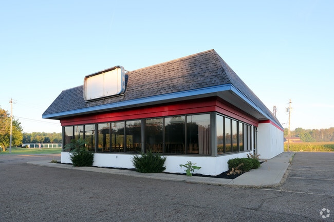


Property Detail
1005 E Ohio Ave
63-03085-001
NEPT RITT 48 & NWPT RITT 47 1.918A MP 48 CD 1910A
Restaurantdrivein
Wayne
M3
Ohio
AE The base floodplain where base flood elevations are provided. AE Zones are now used on new format FIRMs instead of A1-A30 Zones.
1.92 AC
2025
Ohio North Area
2025
Other Market Areas
003400
Wooster, OH
3,513 SF
NEARBY LISTINGS FOR SALE OR LEASE
DEMOGRAPHICS near 1005 E Ohio Ave
1 mile
3 mile
5 mile
2025 Total Population
1,866
13,928
39,694
2030 Population
1,884
14,073
39,942
Pop Growth 2025-2030
+ 0.96%
+ 1.04%
+ 0.62%
Average Age
42
42
42
2025 Total Households
813
5,539
15,896
HH Growth 2025-2030
+ 0.86%
+ 1.01%
+ 0.59%
Median Household Inc
$55,465
$67,069
$72,132
Avg Household Size
2.20
2.40
2.40
2025 Avg HH Vehicles
2.00
2.00
2.00
Median Home Value
$153,799
$215,402
$235,703
Median Year Built
1966
1971
1971
Nearby Places
Map Layers
Map Styles
 Street
 Aerial
Layers
 Traffic
 Biking
Places
Listings with unknown addresses are not visible on the map
- Restaurants
- Banks
- Shops
- Fitness
- Groceries
PUBLIC TRANSPORTATION
AIRPORT
Akron-Canton Regional
Drive
Walk
Distance
Akron-Canton Regional
36 min
27.6 mi
Cleveland-Hopkins International
Drive
Walk
Distance
Cleveland-Hopkins International
52 min
36.0 mi
Nearby Properties
Address
Land Use
TOTAL SIZE
Lot Size
Zoning
Address
Land Use
TOTAL SIZE
Lot Size
Zoning
41,363 SF
43.52 AC
PSM
Address
Land Use
TOTAL SIZE
Lot Size
Zoning
2,626 SF
12.89 AC
Address
Land Use
TOTAL SIZE
Lot Size
Zoning
16,281 SF
14.02 AC
Address
Land Use
TOTAL SIZE
Lot Size
Zoning
51,416 SF
15.13 AC
Address
Land Use
TOTAL SIZE
Lot Size
Zoning
6,573 SF
22.01 AC
Address
Land Use
TOTAL SIZE
Lot Size
Zoning
90,267 SF
10.91 AC
Address
Land Use
TOTAL SIZE
Lot Size
Zoning
66,384 SF
28.30 AC
Address
Land Use
TOTAL SIZE
Lot Size
Zoning
51,022 SF
10.70 AC
Address
Land Use
TOTAL SIZE
Lot Size
Zoning
11,271 SF
9.07 AC
Address
Land Use
TOTAL SIZE
Lot Size
Zoning
106,929 SF
13.79 AC
Address
Land Use
TOTAL SIZE
Lot Size
Zoning
126,672 SF
12.27 AC
Address
Land Use
TOTAL SIZE
Lot Size
Zoning
184,090 SF
22.64 AC
Address
Land Use
TOTAL SIZE
Lot Size
Zoning
18,743 SF
7.01 AC
Address
Land Use
TOTAL SIZE
Lot Size
Zoning
197,262 SF
12.26 AC
Address
Land Use
TOTAL SIZE
Lot Size
Zoning
16,722 SF
18.17 AC
Address
Land Use
TOTAL SIZE
Lot Size
Zoning
20,767 SF
9.35 AC
Address
Land Use
TOTAL SIZE
Lot Size
Zoning
53,642 SF
7.71 AC
Address
Land Use
TOTAL SIZE
Lot Size
Zoning
31,075 SF
3.17 AC
PSM
Address
Land Use
TOTAL SIZE
Lot Size
Zoning
14.21 AC
Address
Land Use
TOTAL SIZE
Lot Size
Zoning
6,615 SF
4.92 AC
Address
Land Use
TOTAL SIZE
Lot Size
Zoning
1,134 SF
270.94 AC
Address
Land Use
TOTAL SIZE
Lot Size
Zoning
32,974 SF
6.18 AC
Address
Land Use
TOTAL SIZE
Lot Size
Zoning
13,980 SF
2.91 AC
PSM
Address
Land Use
TOTAL SIZE
Lot Size
Zoning
5,880 SF
4.84 AC
Address
Land Use
TOTAL SIZE
Lot Size
Zoning
20,000 SF
3.60 AC
M3
Address
Land Use
TOTAL SIZE
Lot Size
Zoning
31,800 SF
6.42 AC
M3
Address
Land Use
TOTAL SIZE
Lot Size
Zoning
27.84 AC
M2
Address
Land Use
TOTAL SIZE
Lot Size
Zoning
15,480 SF
7.70 AC
Address
Land Use
TOTAL SIZE
Lot Size
Zoning
15,240 SF
2.96 AC
Address
Land Use
TOTAL SIZE
Lot Size
Zoning
34,848 SF
3.76 AC
The World's #1 Commercial Real Estate Marketplace
Connect with us
© 2026 CoStar Group
The information above has been obtained from sources believed reliable. While we do not doubt its accuracy we have not verified it and make no guarantee, warranty or representation about it. It is your responsibility to independently confirm its accuracy and completeness. Any projections, opinions, assumptions, or estimates used are for example only and do not represent the current or future performance of the property. The value of this transaction to you depends on tax and other factors which should be evaluated by your tax, financial, and legal advisors. You and your advisors should conduct a careful, independent investigation of the property to determine to your satisfaction the suitability of the property for your needs.